
Jesmond Dene, a public park in the east end of Newcastle upon Tyne, England, occupies the narrow steep-sided valley of a small river known as the Ouseburn, flowing south to join the River Tyne: in north-east England, such valleys are commonly known as denes: the name 'Jesmond' meaning 'mouth of the Ouseburn'.
Newcastle upon Tyne Central is a constituency represented in the House of Commons of the UK Parliament since 2010 by Chi Onwurah of the Labour Party. As with all constituencies, the constituency elects one Member of Parliament (MP) by the first past the post system of election at least every five years. At the 2017 and 2019 general elections, the constituency was the first to officially declare its result. It narrowly beat Houghton and Sunderland South, which had declared first in 2010 and 2015 (as did its predecessor Sunderland South in the four preceding general elections.
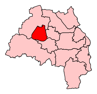
Newcastle upon Tyne North is a constituency represented in the House of Commons of the UK Parliament since 2010 by Catherine McKinnell of the Labour Party.

The Freeman Hospital is an 800-bed tertiary referral centre in Newcastle upon Tyne, England. The hospital is managed by the Newcastle upon Tyne Hospitals NHS Foundation Trust and is a teaching hospital for Newcastle University.
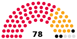
Newcastle City Council is the local government authority for the city and metropolitan borough of Newcastle upon Tyne. The council consists of 78 councillors, three for each of the city's 26 wards. It is currently controlled by the Labour Party, led by Councillor Nick Forbes. Councillor David Cook serves as the Lord Mayor and Councillor Habib Rahman serves as Deputy Lord Mayor and Sheriff. The council is a member of the North of Tyne Combined Authority.

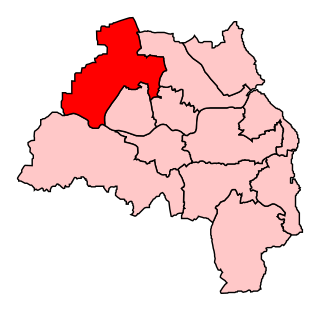
Newcastle upon Tyne East is a constituency represented in the House of Commons of the UK Parliament by Nick Brown of the Labour Party. Brown has held the seat since its recreation in 2010.

Heaton is a suburb in the east end of Newcastle upon Tyne, England, about 2 miles (3 km) from the city centre. It is bordered by the neighbouring areas of High Heaton and Cochrane Park to the north, Walker and Walkergate to the east, Byker to the south and Jesmond and Sandyford to the west. The name Heaton means high town, referring to the area "being situated on hills above the Ouseburn, a tributary of the River Tyne."
Sandyford is a district of Newcastle upon Tyne, located in the east of the city. It borders Jesmond, Central Newcastle, Shieldfield and Heaton.

The Ouseburn is a small river in Tyne and Wear, England that flows through the city of Newcastle upon Tyne into the River Tyne. It gives its name to the Ouseburn electoral ward.

The Tyneside Electrics were the suburban railways on Tyneside that the North Eastern Railway and the London and North Eastern Railway electrified using the third rail system. The North Tyneside Loop was electrified from 1904 onwards and formed one of the earliest suburban electric networks; the South Tyneside line to South Shields via Pelaw was electrified in March 1938. British Railways converted these lines to diesel operation in the 1960s: the line to South Shields in January 1963 and the North Tyneside lines in June 1967 when the electrical supply infrastructure and the rolling stock had become life expired. In addition, the system was losing passengers and suffering from costly vandalism. Since the late 1970s, much of the system has been converted to form the Tyne and Wear Metro.

The A1058 or the Coast Road is a major road in North Tyneside. It runs from Jesmond in Newcastle upon Tyne to Tynemouth, on the coast 8 miles (13 km) to the east from Newcastle City Centre. From Heaton to Billy Mill, the road is built to grade-separated dual carriageway standard. East of Billy Mill, it is known as Beach Road. Just west of Heaton, a new route was built across Jesmond Dene in the 1990s, attracting opposition from environmentalists.

Dene is an electoral ward of Newcastle upon Tyne in North East England. The ward takes its name from the nearby gorge at Jesmond Dene. Contained within the ward are government offices of the Department for Work and Pensions and the Freeman Hospital. The population of the ward is 9,554, increasing to 9,667 at the 2011 Census, 3.7% of the total population of Newcastle upon Tyne. Car ownership in the area is 74.8% much higher than the city average of 54.7%.

Jesmond Park Academy is a coeducational secondary school and sixth form located in Heaton, Newcastle upon Tyne, England.

Jesmond is a suburb of the City of Newcastle LGA, located about 9.5 km (6 mi) west of the Newcastle CBD in the Hunter Region of New South Wales, Australia. It is both a commercial centre and dormitory suburb of Newcastle. Residents include Australian and international students attending the University of Newcastle in adjacent Callaghan. The suburb also has numerous aged housing facilities. The suburb is very multicultural due to many international university students. According to the 2006 Census there were 2,442 people in 1,144 dwellings.

Jesmond is a suburb of Newcastle upon Tyne, situated to the east of the Town Moor. Jesmond is considered to be one of the most affluent suburbs of Newcastle upon Tyne, with higher average house prices than most other areas of the city.

Jesmond Vale is an area in the Ouseburn Valley, Newcastle upon Tyne, England that has a rich history with industrial archaeology, mature trees, and a variety of wildlife. It is a popular open space for recreation and for walkers.
Frank West Rich was an English architect who mainly worked in the Newcastle upon Tyne area.

The 1973 Tyne and Wear County Council election was held on 12 April 1973 as part of the first elections to the new local authorities established by the Local Government Act 1972 in England and Wales. 104 councillors were elected from 95 electoral divisions across the region's five boroughs. Each division returned either one or two county councillors each by First-past-the-post voting for a four-year term of office. The election took place ahead of the elections to the area's metropolitan borough councils, which followed on 10 May 1973.
