
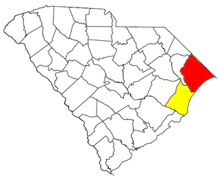
Georgetown County is a county located in the U.S. state of South Carolina. As of the 2020 census, the population was 63,404. Its county seat is Georgetown. The county was founded in 1769. It is named for George III of the United Kingdom.

Washington Township is a township in Clarion County, Pennsylvania, United States. The population was 1,869 at the 2020 census, a decrease from the figure of 1,887 tabulated in 2010.
Jamestown is a town in Berkeley County, South Carolina, United States. The population was 72 at the 2010 census.

Moncks Corner is a town in and the county seat of Berkeley County, South Carolina, United States. The population was 7,885 at the 2010 census. As defined by the U.S. Census Bureau, Moncks Corner is included within the Charleston-North Charleston-Summerville Metropolitan Statistical Area.

McClellanville is a small fishing town in rural Charleston County, South Carolina, United States. The population was 1,040 at the 2010 census. It is situated on the Atlantic coast, on land surrounded by Francis Marion National Forest, and has traditionally derived its livelihood from the Atlantic Ocean and coastal marshes by fishing, shrimping and oystering. McClellanville is part of the Charleston-North Charleston-Summerville metropolitan area and the Charleston-North Charleston Urbanized Area.

The Waccamaw River is a river, approximately 140 miles (225 km) long, in southeastern North Carolina and eastern South Carolina in the United States. It drains an area of approximately 1,110 square miles (2886 km²) in the coastal plain along the eastern border between the two states into the Atlantic Ocean. Along its upper course, it is a slow-moving, blackwater river surrounded by vast wetlands, passable only by shallow-draft watercraft such as canoe. Along its lower course, it is lined by sandy banks and old plantation houses, providing an important navigation channel with a unique geography, flowing roughly parallel to the coast.

The 1st congressional district of South Carolina is a coastal congressional district in South Carolina, represented by Republican Nancy Mace since January 3, 2021. She succeeded Democrat Joe Cunningham, having defeated him in the 2020 election. Cunningham was the first Democrat to represent the district since the 1980s.

The Santee Sioux Reservation of the Santee Sioux was established in 1863 in present-day Nebraska. The tribal seat of government is located in Niobrara, Nebraska, with reservation lands in Knox County.

The Palmetto Trail is a planned 500-mile-long (805 km) foot and mountain bike trail in South Carolina for recreational hiking and biking. Several of the sections are also equestrian trails. It will extend from the Oconee County mountains to the Intracoastal Waterway in Charleston County. It currently consists of 26 segments totaling 350 miles (563 km). Maps and trail guides are available.
The Myrtle Beach metropolitan area is a census-designated metropolitan statistical area consisting of Horry County in South Carolina. The wider Myrtle Beach CSA includes Georgetown County, South Carolina. From 2013 to 2023, Brunswick County, North Carolina was included in the MSA. In 2023, it was moved to the Wilmington, NC Metropolitan Statistical Area, where is was originally located before 2013. The region's primary cities, in order by population are Myrtle Beach, South Carolina; Conway, South Carolina; North Myrtle Beach, South Carolina and Georgetown, South Carolina.

Hopsewee Plantation, also known as the Thomas Lynch, Jr., Birthplace or Hopsewee-on-the-Santee, is a plantation house built in 1735 near Georgetown, South Carolina. It was the birthplace of Thomas Lynch, Jr., a Founding Father who was a signer of the Declaration of Independence, and served as a Lowcountry rice plantation. Before he departed for his ill-fated voyage he made a will, which stipulated that heirs of his female relatives must change their surname to Lynch in order to inherit the family estate, a rice plantation. He was taken ill at the end of 1779 and he sailed, with his wife, for St. Eustatius in the West Indies. Their ship disappeared at sea in a storm and was never found. The family estate, Hopsewee, still stands in South Carolina. The Lynch family sold the house in 1752 to Robert Hume whose son, John Hume, lived at Hopsewee in the winter after inheriting it. Upon his death in 1841, his own son, John Hume Lucas, inherited the house. John Hume Lucas died in 1853. Like many Santee plantations, it was abandoned during the Civil War. After the war, rice was never planted again, but the Lucas family continued to occupy Hopsewee until 1925. In September 1949, Col. and Mrs. Wilkinson bought the house and occupied it.

Plantersville is an unincorporated community in Georgetown County, South Carolina, United States. The community is six miles north of Georgetown on U.S. Route 701. Plantersville is home to many plantations and rice fields. Plantersville Elementary School is also located within the community.
DeBordieu Colony, DeBordieu Beach or simply DeBordieu is a private, unincorporated community and census-designated place (CDP) in Georgetown County, South Carolina, United States. It consists of approximately 2,700 acres (11 km2) of land, of which roughly 800 acres is wildlife preserve inaccessible to the citizens of Georgetown County. Parts of DeBordieu lie on Debidue Island. DeBordieu is located south of Pawleys Island and north of Georgetown east of U.S. Route 17. It is an oceanfront gated community with a private golf and country club.
Chrząstówko is a village in the administrative district of Gmina Człuchów, within Człuchów County, Pomeranian Voivodeship, in northern Poland. It lies approximately 10 kilometres (6 mi) west of Człuchów and 124 km (77 mi) south-west of the regional capital Gdańsk.

Horry-Georgetown Technical College (HGTC) is a public technical college in Conway, South Carolina. It is a part of the South Carolina Technical College System.
Craven County, South Carolina was one of the three original counties established by the Lords Proprietor of the English colony of Carolana in 1682 to include the colony's lands stretching from Awendaw Creek north to the western shore of Winyah Bay and inland. In 1685, the original county of Berkeley was expanded to include the southwestern part of Craven County, and in 1691, land was added to Craven County from the previously unorganized land to its northeast.

Pinopolis Dam is a dam in Berkeley County, South Carolina.
Sunday Lake is a census-designated place (CDP) in Snohomish County, Washington, United States. The population was 640 at the 2010 census.
Cedar Island is a river island in the Santee River of South Carolina roughly ten miles long and two miles wide that separates the Santee into two distributaries, the North Santee and the South Santee, before the river empties into the Atlantic Ocean.
Choppee is an unincorporated community in Georgetown County, in the U.S. state of South Carolina.

