North University Park, Los Angeles

Last updated
North University Park
NorthUniversityParkSignage.jpg
North University Park neighborhood sign
located at the intersection of
Vermont Avenue and Adams Boulevard
Location map Los Angeles.png
Red pog.svg
North University Park
Location within Central Los Angeles
Coordinates: 34°1′48″N118°17′20″W / 34.03000°N 118.28889°W / 34.03000; -118.28889
Country Flag of the United States.svg  United States of America
State Flag of California.svg  California
County Flag of Los Angeles County, California.svg Los Angeles
Time zone Pacific
Zip Code
90007
Area code 213

North University Park is a neighborhood in Los Angeles, California. Located just north of the University of Southern California, North University Park contains two historic districts that are both on the National Register of Historic Places: The North University Park Historic District and the Menlo Avenue–West Twenty-ninth Street Historic District. [1]

Contents

Geography

North University Park is bounded between Vermont Avenue on the West, Figueroa Street on the East, Adams Boulevard on the North and Jefferson Boulevard on the South. [1]

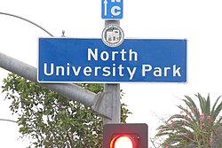
The City of Los Angeles has installed North University Park neighborhood signs [2] at the intersections of Adams Boulevard and Figueroa Street, [3] Adams Boulevard and Vermont Avenue, [4] Jefferson Boulevard and Vermont Avenue, [5] and Jefferson Boulevard and Figueroa Street. [6]

History

Located just north of USC's campus, North University Park was agricultural land until the late nineteenth century. Today, the neighborhood features some of the richest collections of historic architecture in the city of Los Angeles, including Victorian and Craftsman homes dating back to the 1800s. [1]

National Register of Historic Places

There are two Historic Districts in North University Park.

The Menlo Avenue–West Twenty-ninth Street Historic District is bounded by West Adams Boulevard on the north, Ellendale on the east, West Thirtieth Street on the south, and Vermont Avenue to the west. The district was added to the National Register of Historic Places in 1987. [7]

The North University Park Historic District is bounded by West Adams Boulevard on the north, Magnolia Avenue on the west, Hoover Street on the east, and 28th Street on the south. The district was added to the National Register of Historic Places in 2004. [8]

North University Park Specific Plan

Within North University Park is the city designated "North University Park Specific Plan". [9] The Specific Plan applies to the area between Vermont Avenue on the West, Hoover Street on the East, Adams Boulevard on the North and 30th Place on the South. The purpose of the Specific Plan is to regulate floor area ratios, the use of land and buildings, height and bulk of buildings, architectural and landscape treatment, signs, and vehicular and pedestrian circulation.

Notable People

Media

Annalise Keating’s Victorian Home from the television show How to Get Away With Murder is located in North University Park at 1130 W. 27th Street (27th Street at Monmouth Ave). [11]

Related Research Articles

<span class="mw-page-title-main">Pico-Union, Los Angeles</span> Neighborhood of Los Angeles in California, United States of America

Pico-Union is a neighborhood in Central Los Angeles, California. The name "Pico-Union" refers to the neighborhood that surrounds the intersection of Pico Boulevard and Union Avenue. Located immediately west of Downtown Los Angeles, it is home to over 40,000 residents.

<span class="mw-page-title-main">West Adams, Los Angeles</span> Neighborhood of Los Angeles in California, United States

West Adams is a historic neighborhood in the South Los Angeles region of Los Angeles, California. The area is known for its large number of historic buildings, structures and notable houses and mansions.

<span class="mw-page-title-main">Jefferson Park, Los Angeles</span> Neighborhood of Los Angeles in California, United States

Jefferson Park is a neighborhood in the South region of the City of Los Angeles, California. There are five Historic-Cultural Monuments in the neighborhood. In 1987, the Jefferson branch library was added to the National Register of Historic Places.

<span class="mw-page-title-main">Wilshire Boulevard</span> Major thoroughfare in the metropolitan Los Angeles area, United States

Wilshire Boulevard ('wɪɫ.ʃɚ) is a prominent 15.83 mi (25.48 km) boulevard in the Los Angeles area of Southern California, extending from Ocean Avenue in the city of Santa Monica east to Grand Avenue in the Financial District of downtown Los Angeles. One of the principal east–west arterial roads of Los Angeles, it is also one of the major city streets through the city of Beverly Hills. Wilshire Boulevard runs roughly parallel with Santa Monica Boulevard from Santa Monica to the west boundary of Beverly Hills. From the east boundary it runs a block south of Sixth Street to its terminus.

Mid-Wilshire is a neighborhood in the central region of Los Angeles, California. It is known for the Los Angeles County Museum of Art, the Petersen Automotive Museum, and the Miracle Mile shopping district.

<span class="mw-page-title-main">Vermont Square, Los Angeles</span> Neighborhood of Los Angeles in California, United States

Vermont Square is a neighborhood in Los Angeles, California, within the South Los Angeles region. The Vermont Square Branch library, a designated Historic–Cultural Monument, is located in the community.

<span class="mw-page-title-main">Figueroa Street</span> Street in Los Angeles County, California

Figueroa Street is a major north-south street in Los Angeles County, California, spanning from the Los Angeles neighborhood of Wilmington north to Eagle Rock. A short, unconnected continuation of Figueroa Street runs just south of Marengo Drive in Glendale to Chevy Chase Drive in La Cañada Flintridge.

<span class="mw-page-title-main">University Park, Los Angeles</span> Neighborhood of Los Angeles in California, United States

University Park is a 1.17 square miles (3.0 km2) neighborhood in the South Los Angeles region of Los Angeles, California. It is the home of the University of Southern California (USC), Mount St. Mary's College and Hebrew Union College. Additionally, the neighborhood is the home of the historic Shrine Auditorium.

<span class="mw-page-title-main">Menlo Avenue–West Twenty-ninth Street Historic District</span> Historic district in California, United States

The Menlo Avenue–West Twenty-ninth Street Historic District is a historic district in the North University Park neighborhood of Los Angeles, which is itself part of the city's West Adams district. The area consists of late Victorian and Craftsman-style homes dating back to 1896. The area is bounded by West Adams Boulevard on the north, Ellendale on the east, West Thirtieth Street on the south, and Vermont Avenue to the west. The district is noted for its well-preserved period architecture, reflecting the transition from late Victorian and shingle-styles to the American Craftsman style that took hold in Southern California in the early 1900s. The district was added to the National Register of Historic Places in 1987.

<span class="mw-page-title-main">North University Park Historic District</span> Historic district in California, United States

The North University Park Historic District is a historic district in the North University Park neighborhood of Los Angeles, California. The district is bounded by West Adams Boulevard on the north, Magnolia Avenue on the west, Hoover Street on the east, and 28th Street on the south. The district contains numerous well-preserved Victorian houses dating back as far as 1880. In 2004, the district was added to the National Register of Historic Places.

<span class="mw-page-title-main">Jefferson Boulevard</span>

Jefferson Boulevard is a street in Los Angeles and Culver City, California. Its eastern terminus is at Central Avenue east of Exposition Park. At its entrance to Culver City, it splits with National Boulevard. North of Sawtelle Boulevard, it merges with Sepulveda Boulevard. Jefferson returns before Slauson Avenue and ends at Culver Boulevard; its western terminus is near Playa Del Rey.

<span class="mw-page-title-main">Victoria Park, Los Angeles</span> Neighborhood of Los Angeles in California, United States of America

Victoria Park is a small neighborhood in the central region of Los Angeles, California. There are three Los Angeles Historic-Cultural Monuments located in Victoria Park.

<span class="mw-page-title-main">Historic South Central Los Angeles</span> Neighborhood of Los Angeles in California, United States

Historic South Central Los Angeles is a 2.25-square-mile neighborhood in Los Angeles, California, within the South Los Angeles region. It is the site of the Bob Hope Patriotic Hall.

<span class="mw-page-title-main">Exposition Park, Los Angeles</span> Neighborhood of Los Angeles in California, United States

Exposition Park is a neighborhood in the south region of Los Angeles, California. It is home to Exposition Park, which includes the Los Angeles Memorial Coliseum, BMO Stadium, Exposition Rose Garden and three museums: the California African American Museum, the California Science Center and the Natural History Museum of Los Angeles County. It is also home to a Science Center Academy.

<span class="mw-page-title-main">Vermont Vista, Los Angeles</span> Neighborhood of Los Angeles in California, United States

Vermont Vista is a neighborhood in Los Angeles, California, within the South Los Angeles area.

Historic West Adams is a residential and commercial region along the route of the Rosa Parks Freeway, paralleling the east-west Adams Boulevard in Los Angeles, California. With variously described boundaries, the area was an exclusive residential district In the late 19th and early 20th centuries for many wealthy and influential people. It underwent a period of deterioration, but many of its stately old buildings have been and are being rehabilitated and preserved.

<span class="mw-page-title-main">Angelus Vista, Los Angeles</span> Neighborhood of Los Angeles in California, United States

Angelus Vista is a neighborhood in Los Angeles, California. There is one Los Angeles Historic-Cultural Monument in neighborhood.

<span class="mw-page-title-main">Magnolia Square, Los Angeles</span> Neighborhood of Los Angeles in California, United States

Magnolia Square is a neighborhood in Los Angeles, California.

West Adams Terrace is a neighborhood in Los Angeles. Dating back to 1905, it contains seven Los Angeles Historic-Cultural Monuments, one property on the National Register of Historic Places and one Green Book property. In 2003, the neighborhood was designated a Historic Preservation Overlay Zone.

References

  1. 1 2 3 Charles Epting (2 July 2013). University Park, Los Angeles: A Brief History. Arcadia Publishing Incorporated. pp. 67–. ISBN   978-1-62584-028-8.
  2. "Neighborhood Signs LAcity.org". Archived from the original on 2019-07-09. Retrieved 2020-04-14.
  3. "Neighborhood Sign located at Adams Boulevard and Figueroa Street". Google Street View .
  4. "Neighborhood Sign located at Adams Boulevard and Vermont Avenue". Google Street View.
  5. "Neighborhood Sign located at Jefferson Boulevard and Vermont Avenue". Google Street View.
  6. "Neighborhood Sign located at Jefferson Boulevard and Figueroa Street". Google Street View.
  7. "NPGallery Asset Detail". Npgallery.nps.gov. Retrieved 2018-10-04.
  8. "NPGallery Asset Detail". Npgallery.nps.gov. Retrieved 2018-10-04.
  9. "Spec plan" (PDF). planning.lacity.org.
  10. "Adlai Stevenson". hmdb.org. Retrieved 3 March 2023.
  11. GJW. "How To Get Away With Murder - Filming Locations". www.seeing-stars.com.

Notes