
Pymble is a suburb on the Upper North Shore of Sydney in the state of New South Wales, Australia. Pymble is 15 kilometres (9 mi) north of the Sydney central business district in the local government area of Ku-ring-gai Council.

Ku-ring-gai Council is a local government area in Northern Sydney, in the state of New South Wales, Australia. The area is named after a fictional Aboriginal Language Group.
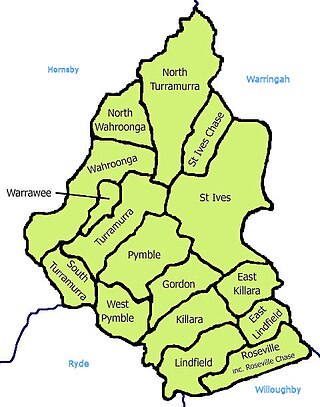
St Ives is a suburb on the Upper North Shore of Sydney in the state of New South Wales, Australia 18 kilometres north of the Sydney Central Business District in the local government area of Ku-ring-gai Council. St Ives Chase is a separate adjacent area, designated suburb, to the west and north.

The North Shore is a region within Northern Sydney, in New South Wales, Australia, generally referring to suburbs located on the northern side of Sydney Harbour up to Wahroonga, and suburbs between Middle Harbour and the Lane Cove River.

Warrawee is a suburb on the Upper North Shore of Sydney in the state of New South Wales, Australia. Warrawee is located 17 kilometres north-west of the Sydney Central Business District, in the local government area of Ku-ring-gai Council. Warrawee is predominantly a residential suburb with few commercial entities. Notably, its railway station supports no commercial activities, which is uncommon on the Sydney train network.

Wahroonga is a suburb in the Upper North Shore of Sydney, in the state of New South Wales, Australia, 18 kilometres north-west of the Sydney central business district, in the local government areas of Ku-ring-gai Council and Hornsby Shire. North Wahroonga is an adjacent separate suburb of the same postcode.

Turramurra is a suburb on the Upper North Shore of Sydney, in the state of New South Wales, Australia. It is located 16 kilometres (10 mi) north-west of the Sydney central business district, in the local government area of Ku-ring-gai Council. It shares the postcode of 2074 with the adjacent suburbs of North Turramurra, South Turramurra and Warrawee.

Killara is a suburb on the Upper North Shore of Sydney in the state of New South Wales, Australia 14 kilometres (8.7 mi) north-west of the Sydney central business district in the local government area of Ku-ring-gai Council. East Killara is a separate suburb and West Killara is a locality within Killara.

Asquith is an outer suburb of Northern Sydney in the state of New South Wales, Australia. Asquith is located 26 km north-west of the Sydney central business district, in the local government area of Hornsby Shire. The suburb contains a section of Ku-ring-gai Chase National Park on its eastern side.

Berowra railway station is located on the Main Northern Line, serving the Sydney suburb of Berowra. It is served by Sydney Trains T1 North Shore Line services and NSW TrainLink Central Coast & Newcastle Line services.

Thornleigh is a suburb in the Upper North Shore region of Sydney in the state of New South Wales, Australia. Thornleigh is located 22 kilometres north-west of the Sydney central business district in the local government area of Hornsby Shire. The source of the Lane Cove River is located in Thornleigh.
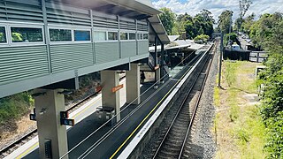
Turramurra railway station is located on the North Shore line, serving the Sydney suburb of Turramurra. It is served by Sydney Trains T1 North Shore line services.

West Pymble is a suburb on the Upper North Shore of Sydney in the state of New South Wales, Australia 15 kilometres (9.3 mi) north-west of the Sydney Central Business District in the local government area of Ku-ring-gai Council. Pymble is a separate suburb to the east, sharing the postcode of 2073.

Wahroonga railway station is a heritage-listed railway station located on the North Shore line, serving the Sydney suburb of Wahroonga. The station is located in the Ku-ring-gai Council local government area of New South Wales, Australia. It is served by Sydney Trains T1 North Shore line services. It was built from 1890 to 1910 by E. Pritchard & Co., contractor. It is also known as Wahroonga Railway Station group and Pearce's Corner; Noonan's Platform. The property was added to the New South Wales State Heritage Register on 2 April 1999.

North Turramurra is a suburb on the Upper North Shore of Sydney, in the state of New South Wales, Australia. North Turramurra is located 20 kilometres (12 mi) north-west of the Sydney central business district, in the local government area of Ku-ring-gai Council. Turramurra and South Turramurra are separate suburbs.

South Turramurra is a suburb on the Upper North Shore of Sydney in the state of New South Wales, Australia 18 kilometres (11 mi) north-west of the Sydney central business district, in the local government area of Ku-ring-gai Council. Turramurra and North Turramurra are separate suburbs.

Roseville is a suburb on the Upper North Shore of Sydney in the state of New South Wales, Australia 12 kilometres (7.5 mi) north-west of the Sydney central business district, in the local government areas of Ku-ring-gai and Willoughby. Roseville Chase is a separate suburb to the east.
North Curl Curl is a suburb in northern Sydney, in the state of New South Wales, Australia 19 kilometres north-east of the Sydney central business district, in the local government area of Northern Beaches Council. It is part of the Northern Beaches region.

Mount Kuring-gai is an outer suburb of Northern Sydney, in the state of New South Wales, Australia. Mount Kuring-gai is located 31 kilometres north-west of the Sydney central business district, in the local government area of Hornsby Shire.

Ku-ring-gai was an electoral district of the Legislative Assembly in the Australian state of New South Wales. The electorate covers the suburbs and parts of the suburbs of Gordon, Hornsby, Killara, Lindfield, Normanhurst, North Turramurra, North Wahroonga, Pymble, South Turramurra, Thornleigh, Turramurra, Wahroonga, Waitara, Warrawee and West Pymble.

