Summit County is an urban county in the U.S. state of Ohio. As of the 2020 census, the population was 540,428, making it the fourth-most populous county in Ohio. Its county seat and largest city is Akron. The county was formed on March 3, 1840, from portions of Medina, Portage and Stark counties. It was named Summit County because the highest elevation on the Ohio and Erie Canal is in the county.

Cuyahoga Falls is a city in Summit County, Ohio, United States. As of the 2020 census, the city population was 51,114. The second-largest city in Summit County, it is located directly north of Akron and is a suburb of the Akron metropolitan area. The city was founded in 1812 by William Wetmore and was originally named Manchester, but renamed for the Cuyahoga River and the series of waterfalls that run along the southern boundary of the city.

Munroe Falls is a city in east-central Summit County, Ohio, United States, along the Cuyahoga River. The population was 5,044 at the 2020 census. It is a suburb of Akron and is part of the Akron metropolitan area.

Stow is a city in Summit County, Ohio, United States. The population was 34,483 at the 2020 census. It is a suburban community within the Akron metropolitan area.
William Wetmore founded Cuyahoga Falls, Ohio in 1812.

Northeast Ohio is a geographic and cultural region that comprises the northeastern counties of the U.S. state of Ohio. Definitions of the region consist of 16 to 23 counties between the southern shore of Lake Erie and the foothills of the Appalachian Mountains, home to over 4.5 million people. It is anchored by the metropolitan area of Cleveland, the most populous city in the region with over 372,000 residents in 2020. Other metropolitan centers include Akron, Canton, Mansfield, Sandusky, and Youngstown. Northeast Ohio includes most of the area known historically as the Connecticut Western Reserve.

Bath Township is one of the nine townships of Summit County, Ohio, United States. A suburb of Akron, the 2020 census found 10,024 people in the township.
Portage Township was one of the sixteen original townships in Summit County, Ohio. It was located in the middle of Summit County. It included the cities/towns of Akron and Cuyahoga Falls as well as an earlier part of Middlebury. Eventually, the township was absorbed by Akron and Cuyahoga Falls and ceased to exist. When created, it was in area and included Survey Town 2, Range 11 in Western Reserve. The township derived its name from the Portage Path, which extends north to south through the middle of the township.

State Route 59 is an east–west state highway in the U.S. state of Ohio, serving the Akron metropolitan area. The western terminus of State Route 59 is in downtown Akron at a partial interchange with the Interstate 76/Interstate 77 concurrency, and the eastern terminus is at State Route 5, 0.5 miles (0.80 km) east of Ravenna. The route is approximately 23 miles (37 km) long and was certified in 1969 over what had previously been part of SR 5. It serves as a major or as the primary east–west roadway for the cities of Cuyahoga Falls, Kent, Ravenna, and Stow, the village of Silver Lake, and Franklin and Ravenna Townships.

Springfield Township is one of the nine townships of Summit County, Ohio, United States. The population was 14,162 at the 2020 census.
Botzum was a hamlet in Northampton Township, Summit County, Ohio around what is now the intersection of Bath and Riverview Roads in Akron and Cuyahoga Falls.

Boston Township is one of the nine townships of Summit County, Ohio, United States, about 15 miles (24 km) north of Akron and 23 miles (37 km) south of Cleveland. It is part of the Akron metropolitan area. The 2020 census found 1,401 people in the township.

Franklin Township is a civil township in Portage County, Ohio, United States. It is on the Cuyahoga River in Northeast Ohio on the western edge of the county. The 2010 Census found 5,527 people in the township and the 2020 census recorded 6,283 people. The township is part of the Akron Metropolitan Statistical Area and the larger Cleveland–Akron–Canton Combined Statistical Area.

State Route 91, formerly known as Inter-county Highway 91 until 1921 and State Highway 91 in 1922, is a north–south state highway in the northeastern portion of the U.S. state of Ohio. Its southern terminus is at U.S. Route 224 in Springfield Township, east of Akron. Its northern terminus is at State Route 283 on the Timberlake/Eastlake border less than one mile (1.6 km) south of Lake Erie.

State Route 532 is a north–south state highway in the northeastern portion of the U.S. state of Ohio. The highway runs from its southern terminus at a signalized intersection with U.S. Route 224 (US 224) on the Summit–Portage county line approximately 0.75 miles (1.21 km) south of Mogadore on the border of Springfield Township and Suffield Township to its northern terminus at a diamond interchange with Interstate 76 (I-76), at its exit 29 within the Tallmadge city limits.

Olmsted Township is a township located in Cuyahoga County, Ohio, United States. Situated in the southwest end of the county, Olmsted Township is a west side suburb of Cleveland, and a part of the even larger Greater Cleveland area. As of the 2020 Census, Olmsted Township had a population of 14,506. It is one of only two civil townships remaining in Cuyahoga County, and the only Olmsted Township statewide.
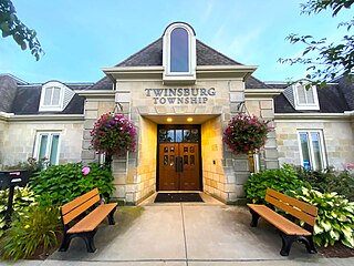
Twinsburg Township is one of the nine townships of Summit County, Ohio, United States. The 2020 census found 3,857 people in the township.

The Akron, OH Metropolitan Statistical Area, sometimes referred to as Greater Akron, is defined by the United States Office of Management and Budget as an area consisting of two counties, Summit and Portage, in Northeast Ohio and anchored by the city of Akron. As of the 2020 census, the MSA had a population of 702,219. The Akron MSA is also part of the larger Cleveland–Akron–Canton, OH Combined Statistical Area, which has a population of 3,633,962 people as of the 2020 census, the largest metropolitan area in Ohio.
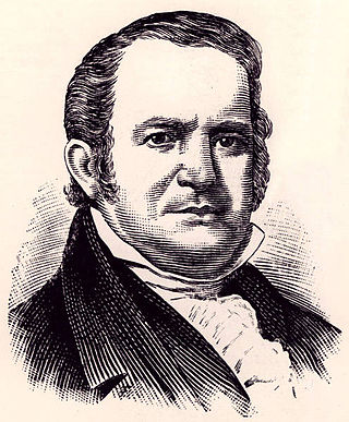
General Simon Perkins was an early settler, businessman and surveyor of the Western Reserve of Connecticut, which would later become northeast Ohio. He co-founded Akron, Ohio, with Paul Williams in 1825. He served as a brigadier-general during the War of 1812.
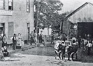
Simeon Prior was a blacksmith and Revolutionary War soldier, who in 1802 along with his family founded Northampton Township, Ohio, now a part of Cuyahoga Falls, Ohio. The original family farm was located in what was called the Connecticut Western Reserve on the eastern shoulder of the Cuyahoga Valley.

