Northern Forested Ghauts

Last updated
Map of Montserrat Topographic-map-of-Montserrat-en.svg
Map of Montserrat
The IBA is an important site for Antillean crested hummingbirds Antillean crested hummingbird feeding.jpg
The IBA is an important site for Antillean crested hummingbirds

The Northern Forested Ghauts constitute a tract of land on the island of Montserrat, a British Overseas Territory in the Leeward Islands of the Caribbean Sea. It forms one of the territory's Important Bird Areas (IBAs).

Montserrat British Overseas Territory in the Caribbean

Montserrat is a British Overseas Territory (BOT) in the Caribbean. The island is in the Leeward Islands, which is part of the chain known as the Lesser Antilles, in the West Indies. Montserrat measures approximately 16 km (10 mi) in length and 11 km (7 mi) in width, with approximately 40 km (25 mi) of coastline. Montserrat is nicknamed "The Emerald Isle of the Caribbean" both for its resemblance to coastal Ireland and for the Irish ancestry of many of its inhabitants.

British Overseas Territories Territories under the jurisdiction and sovereignty of the United Kingdom

The British Overseas Territories (BOTs) or United Kingdom Overseas Territories (UKOTs) are fourteen territories under the jurisdiction and sovereignty of the United Kingdom. They are remnants of the British Empire that have not been granted independence or have voted to remain British territories. These territories do not form part of the United Kingdom and, with the exception of Gibraltar, are not part of the European Union. Most of the permanently inhabited territories are internally self-governing, with the UK retaining responsibility for defence and foreign relations. Three are inhabited only by a transitory population of military or scientific personnel. They all share the British monarch as head of state.

Leeward Islands subgroup of islands in the West Indies

The Leeward Islands are a group of islands geographically situated where the northeastern Caribbean Sea meets the western Atlantic Ocean. Starting with the Virgin Islands east of Puerto Rico, they extend southeast to Guadeloupe and its dependencies. In English, the term Leeward Islands refers to the northern islands of the Lesser Antilles chain. The more southerly part of this chain, geographically starts with Martinique and is called the Windward Islands. The island of Dominica is geographically and historically part of the Leeward Islands, however for political reasons in 1940 the management of the island was transferred from the British Leeward Islands to the British Windward Islands.

Contents

Description

The 498 ha IBA lies in the north of the island. It is disjunct, consisting of several linear sites radiating from the forested Centre Hills block of the island into the northern lowlands. The component sites encompass mainly northward flowing streams (the ravines of which are known locally as ‘ghauts’) that retain fringes and patches of remnant tropical deciduous and semideciduous native forest. Much of the native vegetation is fragmented and surrounded by cultivated and residential land. Other IBAs on the island are the Centre Hills and South Soufriere Hills. [1]

Ravine Small valley, which is often the product of streamcutting erosion

A ravine is a landform that is narrower than a canyon and is often the product of streamcutting erosion. Ravines are typically classified as larger in scale than gullies, although smaller than valleys.

Tropical and subtropical moist broadleaf forests Biome

Tropical and subtropical moist broadleaf forests (TSMF), also known as tropical moist forests, are a tropical and subtropical forest habitat type defined by the World Wide Fund for Nature. The habitat type is sometimes known as jungle.

Centre Hills hill in Montserrat

Centre Hills is a forest reserve on the island of Montserrat, a British Overseas Territory in the Leeward Islands of the Caribbean Sea. It forms one of the territory's Important Bird Areas (IBAs), which encompasses the forest reserve as well as additional habitat for the Montserrat oriole, the territory's endemic, and critically endangered, national bird.

Birds

The IBA was identified as such by BirdLife International because it supports populations of bridled quail-doves, purple-throated caribs, green-throated caribs, Antillean crested hummingbirds, Caribbean elaenias, scaly-breasted thrashers, pearly-eyed thrashers, brown tremblers, forest thrushes, Lesser Antillean bullfinches and Antillean euphonias. [1]

BirdLife International is a global partnership of conservation organisations that strives to conserve birds, their habitats, and global biodiversity, working with people towards sustainability in the use of natural resources. It is the world's largest partnership of conservation organisations, with over 120 partner organisations.

Bridled quail-dove species of bird

The bridled quail-dove is a species of bird in the family Columbidae. It is found from Saint Lucia, northward to the Virgin Islands and Puerto Rico. Its natural habitats are subtropical or tropical dry forest and subtropical or tropical moist lowland forest.

Purple-throated carib species of bird

The purple-throated carib is a species of hummingbird in the family Trochilidae.

Related Research Articles

Cove Pond

Cove Pond is a shallow 287 ha wetland at the south-western end of the Caribbean island of Anguilla, a British Overseas Territory. It forms part of a larger coastal lagoon from which it is separated by a causeway constructed for access to the Cap Juluca resort.

Grey Pond

Grey Pond is a 191 ha shallow, brackish lagoon at the eastern end of the main island of Anguilla, a British Overseas Territory in the Caribbean. Its southern and eastern shores are relatively steep-sided limestone slopes, while its north-eastern corner is separated from Savannah Bay by a belt of sand dunes. The limestone shores are covered by low, scrub vegetation.

Mlima Combani and Mlima Mtsapéré Important Bird Area

The Mlima Combani and Mlima Mtsapéré Important Bird Area lies in the north-central part of the French island territory of Mayotte in the Comoro Islands, lying at the northern end of the Mozambique Channel between the East African country of Mozambique and Madagascar.

Tilomar Important Bird Area

The Tilomar Important Bird Area, also known as Tilomar Forest, is a tract of mainly forested land in East Timor, a country occupying the eastern end of the island of Timor in the Lesser Sunda Islands of Wallacea.

Botanic Park and Salina Reserve Important Bird Area

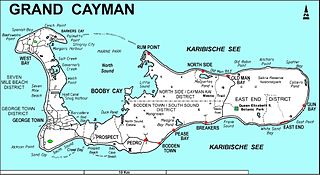
The Botanic Park and Salina Reserve Important Bird Area comprises two separate sites on Grand Cayman, one of the Cayman Islands, a British Overseas Territory in the Caribbean Sea.

Central Mangrove Wetland

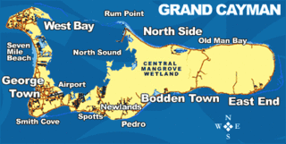
The Central Manrove Wetland is a large area of mangrove dominated wetland on Grand Cayman, one of the Cayman Islands, a British Overseas Territory in the Caribbean Sea. It is one of the territory's Important Bird Areas (IBAs).

Eastern Dry Forest

The Eastern Dry Forest lies at the eastern end of Grand Cayman, one of the Cayman Islands, a British Overseas Territory in the Caribbean Sea. It is one of the territory’s Important Bird Areas (IBAs).

Frank Sound Forest

Frank Sound Forest lies near the southern coast of the East End distinct of Grand Cayman, one of the Cayman Islands, a British Overseas Territory in the Caribbean Sea. It is one of the territory’s Important Bird Areas (IBAs).

Franklins Forest

Franklin's Forest lies near the centre of the East End distinct of Grand Cayman, one of the Cayman Islands, a British Overseas Territory in the Caribbean Sea. It is one of the territory’s Important Bird Areas (IBAs).

Mastic Reserve

Mastic Reserve lies at the eastern end of the North Side of Grand Cayman, one of the Cayman Islands, a British Overseas Territory in the Caribbean Sea. It, with the associated Mastic Trail, is managed by the National Trust for the Cayman Islands and is one of the territory's Important Bird Areas (IBAs). It is named after the yellow mastic and black mastic trees which occur in the reserve.

Sparrowhawk Hill hill in Cayman Islands, United Kingdom

Sparrowhawk Hill lies in the centre of Little Cayman, one of the Cayman Islands, a British Overseas Territory in the Caribbean Sea. It is one of the territory's Important Bird Areas (IBAs).

Road Salt Pond

Road Salt Pond, also known as Road Bay Pond or simply Road Pond, is a wetland in Anguilla, a British Overseas Territory in the Caribbean Sea. It is one of the territory's Important Bird Areas (IBAs).

Cauls Pond

Cauls Pond is a wetland in Anguilla, a British Overseas Territory in the Caribbean Sea. It is one of the territory's Important Bird Areas (IBAs).

Merrywing Pond System

The Merrywing Pond System is a golf course wetland system in Anguilla, a British Overseas Territory in the Caribbean Sea. It forms one of the territory’s Important Bird Areas (IBAs).

Forest Bay Pond

Forest Bay Pond is a small wetland in Anguilla, a British Overseas Territory in the Caribbean Sea. It forms one of the territory’s Important Bird Areas (IBAs).

South Soufriere Hills

South Soufriere Hills is a 35 ha patch of forest on the island of Montserrat, a British Overseas Territory in the Leeward Islands of the Caribbean Sea. It forms one of the territory's Important Bird Areas (IBAs).

Wades Green and Teren Hill Important Bird Area

The Wades Green and Teren Hill Important Bird Area is a 226 ha tract of land on the island of North Caicos in the Turks and Caicos Islands, a British Overseas Territory in the Lucayan Archipelago of the western Atlantic Ocean. It forms one of the territory's Important Bird Areas (IBAs).

Petite Terre Islands National Nature Reserve

Petite Terre Islands National Nature Reserve is a reserve of the Petite Terre Islands in Guadeloupe. The reserve was established by Decree No. 98-801 of 3 September 1998 as the nature reserve for the islands of Petite Terre. It covers an area of about 990 hectares, which is demarcated by five points fixed with buoys, and includes a land area of 148.6 hectares with the balance as sea area.

References

  1. 1 2 "Northern Forested Ghauts". Important Bird Areas factsheet. BirdLife International. 2014. Retrieved 2014-04-14.

Coordinates: 16°47′00″N62°12′00″W / 16.78333°N 62.20000°W / 16.78333; -62.20000

Geographic coordinate system Coordinate system

A geographic coordinate system is a coordinate system that enables every location on Earth to be specified by a set of numbers, letters or symbols. The coordinates are often chosen such that one of the numbers represents a vertical position and two or three of the numbers represent a horizontal position; alternatively, a geographic position may be expressed in a combined three-dimensional Cartesian vector. A common choice of coordinates is latitude, longitude and elevation. To specify a location on a plane requires a map projection.