South Soufriere Hills

Last updated
Map of Montserrat Topographic-map-of-Montserrat-en.svg
Map of Montserrat

South Soufriere Hills is a 35 ha patch of forest on the island of Montserrat, a British Overseas Territory in the Leeward Islands of the Caribbean Sea. It forms one of the territory’s Important Bird Areas (IBAs). [1]

Montserrat British Overseas Territory in the Caribbean

Montserrat is a Caribbean island in the Leeward Islands, which is part of the chain known as the Lesser Antilles, in the West Indies. It is a British Overseas Territory (BOT). Montserrat measures approximately 16 km (10 mi) in length and 11 km (7 mi) in width, with approximately 40 km (25 mi) of coastline. Montserrat is nicknamed "The Emerald Isle of the Caribbean" both for its resemblance to coastal Ireland and for the Irish ancestry of many of its inhabitants.

British Overseas Territories territory under the jurisdiction and sovereignty of the United Kingdom but not part of it

The British Overseas Territories (BOTs) or United Kingdom Overseas Territories (UKOTs) are 14 territories under the jurisdiction and sovereignty of the United Kingdom. They are remnants of the British Empire that have not been granted independence or have voted to remain British territories. These territories do not form part of the United Kingdom and, with the exception of Gibraltar, are not part of the European Union. Most of the permanently inhabited territories are internally self-governing, with the UK retaining responsibility for defence and foreign relations. Three are inhabited only by a transitory population of military or scientific personnel. They all share the British monarch as head of state.

Leeward Islands group of islands in the West Indies

The Leeward Islands are a group of islands situated where the northeastern Caribbean Sea meets the western Atlantic Ocean. Starting with the Virgin Islands east of Puerto Rico, they extend southeast to Guadeloupe and its dependencies. In English, the term Leeward Islands refers to the northern islands of the Lesser Antilles chain. The more southerly part of this chain, starting with Dominica, is called the Windward Islands. Dominica was originally considered part of the Leeward Islands, but was transferred from the British Leeward Islands to the British Windward Islands in 1940.

Contents

Description

Aerial view of Montserrat from the south-east, showing (right) the Centre Hills and the inhabited northern end of the island, and (left) the Soufriere Hills, with the ash plume being emitted from the volcano MontserratWestIndies.jpg
Aerial view of Montserrat from the south-east, showing (right) the Centre Hills and the inhabited northern end of the island, and (left) the Soufrière Hills, with the ash plume being emitted from the volcano

The IBA comprises the largest remnant of Montserrat’s native forest in the Soufrière Hills, in the exclusion zone. It has survived the volcanic eruptions and pyroclastic flows that have devastated and depopulated the southern half of the island since the late 1990s. It lies only about 1.5 km south of 915 m Chances Peak, the highest point of the island and the Soufrière Hills stratovolcano. It ranges in elevation from 200  to 750 m above sea level and contains tropical evergreen forest. Other IBAs on the island are the Northern Forested Ghauts and Centre Hills. [1]

Soufrière Hills mountain, a volcano on Montserrat in the Caribbean

The Soufrière Hills volcano is an active, complex stratovolcano with many lava domes forming its summit on the Caribbean island of Montserrat. Many volcanoes in the Caribbean are named Soufrière. These include La Soufrière or Soufrière Saint Vincent on the island of Saint Vincent and La Grande Soufrière on Guadeloupe. After a long period of dormancy, the Soufrière Hills volcano became active in 1995 and has continued to erupt ever since. Its eruptions have rendered more than half of Montserrat uninhabitable, destroying the capital city, Plymouth, and causing widespread evacuations: about two thirds of the population have left the island.

Types of volcanic eruptions Basic mechanisms of eruption and variations

Several types of volcanic eruptions—during which lava, tephra, and assorted gases are expelled from a volcanic vent or fissure—have been distinguished by volcanologists. These are often named after famous volcanoes where that type of behavior has been observed. Some volcanoes may exhibit only one characteristic type of eruption during a period of activity, while others may display an entire sequence of types all in one eruptive series.

Pyroclastic flow Fast-moving current of hot gas and volcanic matter that moves away from a volcano

A pyroclastic flow is a fast-moving current of hot gas and volcanic matter that moves away from a volcano about 100 km/h (62 mph) on average but is capable of reaching speeds up to 700 km/h (430 mph). The gases can reach temperatures of about 1,000 °C (1,830 °F).

Birds

The IBA was identified as such by BirdLife International because it supports, populations of bridled quail-doves, green-throated caribs, Antillean crested hummingbirds, scaly-breasted thrashers, pearly-eyed thrashers, brown tremblers, forest thrushes, Montserrat orioles and Lesser Antillean bullfinches. [1]

BirdLife International is a global partnership of conservation organisations that strives to conserve birds, their habitats, and global biodiversity, working with people towards sustainability in the use of natural resources. It is the world's largest partnership of conservation organisations, with over 120 partner organisations.

Bridled quail-dove species of bird

The bridled quail-dove is a species of bird in the family Columbidae. It is found from Saint Lucia, northward to the Virgin Islands and Puerto Rico. Its natural habitats are subtropical or tropical dry forest and subtropical or tropical moist lowland forest.

Green-throated carib species of bird

The green-throated carib is a species of hummingbird in the genus Eulampis, which contains one other species. It has two subspecies, holosericeus and chlorolaemus, the former occurring in Puerto Rico and the latter in Grenada.

Related Research Articles

Geography of Montserrat

Montserrat is an island in the Caribbean Sea, in the Leeward Islands. Its nearest neighbours in the island chain include Guadeloupe to the south-east, Antigua to the north-east and Nevis to the north-west. The island is 16 km (9.9 mi) long and 11 km (6.8 mi) wide, with a coastline of about 40 km.

Montserrat oriole species of bird

The Montserrat oriole is a medium-sized black-and-yellow icterid.

The Bluff (Cayman Islands) mountain in the Cayman Islands


The Bluff is the highest part of the Cayman Islands, a British Overseas Territory in the Caribbean Sea. It stands at the eastern end of the island of Cayman Brac and has a maximum elevation of 43 m (141 ft).

Saziley National Park

Saziley National Park is a national park in Mayotte, a French island territory in the Comoro archipelago of the western Indian Ocean. It was established in 1991.

Sogam-do, Daegam-do, Zung-do, Ae-do and Hyengzedo Islands Important Bird Area

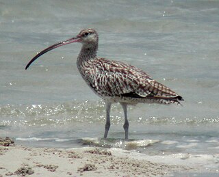
The Sogam-do, Daegam-do, Zung-do, Ae-do and Hyengzedo Islands Important Bird Area comprises a group of small islands, with a collective area of 18 ha, in the north-eastern Yellow Sea, lying close to the western coast of North Korea. The site has been identified by BirdLife International as an Important Bird Area (IBA) because it supports breeding endangered black-faced spoonbills as well as vulnerable Chinese egrets and up to 850 Far Eastern curlews as passage migrants. The site has been designated one of North Korea’s Natural Monuments.

Lake Rangrim, also known as Lake Nangnim, is an artificial lake in the Rangrim Mountains of Chagang Province in northern North Korea. It was formed by damming a river valley to produce hydroelectricity. The lake, with its adjacent temperate broadleaf and mixed forest habitats, has been identified by BirdLife International as an 8600 ha Important Bird Area (IBA). The IBA lies at an altitude of 700–1700 m above sea level.

Mlima Combani and Mlima Mtsapéré Important Bird Area

The Mlima Combani and Mlima Mtsapéré Important Bird Area lies in the north-central part of the French island territory of Mayotte in the Comoro Islands, lying at the northern end of the Mozambique Channel between the East African country of Mozambique and Madagascar.

Botanic Park and Salina Reserve Important Bird Area

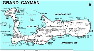
The Botanic Park and Salina Reserve Important Bird Area comprises two separate sites on Grand Cayman, one of the Cayman Islands, a British Overseas Territory in the Caribbean Sea.

Frank Sound Forest

Frank Sound Forest lies near the southern coast of the East End distinct of Grand Cayman, one of the Cayman Islands, a British Overseas Territory in the Caribbean Sea. It is one of the territory’s Important Bird Areas (IBAs).

Franklins Forest

Franklin's Forest lies near the centre of the East End distinct of Grand Cayman, one of the Cayman Islands, a British Overseas Territory in the Caribbean Sea. It is one of the territory’s Important Bird Areas (IBAs).

Mastic Reserve

Mastic Reserve lies at the eastern end of the North Side of Grand Cayman, one of the Cayman Islands, a British Overseas Territory in the Caribbean Sea. It, with the associated Mastic Trail, is managed by the National Trust for the Cayman Islands and is one of the territory's Important Bird Areas (IBAs). It is named after the yellow mastic and black mastic trees which occur in the reserve.

Sparrowhawk Hill

Sparrowhawk Hill lies in the centre of Little Cayman, one of the Cayman Islands, a British Overseas Territory in the Caribbean Sea. It is one of the territory’s Important Bird Areas (IBAs).

Road Salt Pond

Road Salt Pond, also known as Road Bay Pond or simply Road Pond, is a wetland in Anguilla, a British Overseas Territory in the Caribbean Sea. It is one of the territory’s Important Bird Areas (IBAs).

Cauls Pond

Cauls Pond is a wetland in Anguilla, a British Overseas Territory in the Caribbean Sea. It is one of the territory’s Important Bird Areas (IBAs).

West End Pond

West End Pond is a wetland in Anguilla, a British Overseas Territory in the Caribbean Sea. It is one of the territory’s Important Bird Areas (IBAs).

Merrywing Pond System

The Merrywing Pond System is a golf course wetland system in Anguilla, a British Overseas Territory in the Caribbean Sea. It forms one of the territory’s Important Bird Areas (IBAs).

Forest Bay Pond

Forest Bay Pond is a small wetland in Anguilla, a British Overseas Territory in the Caribbean Sea. It forms one of the territory’s Important Bird Areas (IBAs).

Northern Forested Ghauts

The Northern Forested Ghauts constitute a tract of land on the island of Montserrat, a British Overseas Territory in the Leeward Islands of the Caribbean Sea. It forms one of the territory’s Important Bird Areas (IBAs).

Centre Hills hill in Montserrat

Centre Hills is a forest reserve on the island of Montserrat, a British Overseas Territory in the Leeward Islands of the Caribbean Sea. It forms one of the territory’s Important Bird Areas (IBAs), which encompasses the forest reserve as well as additional habitat for the Montserrat oriole, the territory’s endemic, and critically endangered, national bird.

Wades Green and Teren Hill Important Bird Area

The Wades Green and Teren Hill Important Bird Area is a 226 ha tract of land on the island of North Caicos in the Turks and Caicos Islands, a British Overseas Territory in the Lucayan Archipelago of the western Atlantic Ocean. It forms one of the territory’s Important Bird Areas (IBAs).

References

  1. 1 2 3 "South Soufriere Hills". Important Bird Areas factsheet. BirdLife International. 2014. Retrieved 2014-04-17.

Coordinates: 16°42′00″N62°10′00″W / 16.70000°N 62.16667°W / 16.70000; -62.16667

Geographic coordinate system Coordinate system

A geographic coordinate system is a coordinate system that enables every location on Earth to be specified by a set of numbers, letters or symbols. The coordinates are often chosen such that one of the numbers represents a vertical position and two or three of the numbers represent a horizontal position; alternatively, a geographic position may be expressed in a combined three-dimensional Cartesian vector. A common choice of coordinates is latitude, longitude and elevation. To specify a location on a plane requires a map projection.