Related Research Articles

Montana is a state in the Mountain West division of the Western United States. It is bordered by Idaho to the west, North Dakota and South Dakota to the east, Wyoming to the south, and the Canadian provinces of Alberta, British Columbia, and Saskatchewan to the north. It is the fourth-largest state by area, the eighth-least populous state, and the third-least densely populated state. Its state capital is Helena, while the largest city is Billings. The western half of Montana contains numerous mountain ranges, while the eastern half is characterized by western prairie terrain and badlands, with smaller mountain ranges found throughout the state. The state has a reputation for a libertarian bent in popular opinion and policy.

Scouting in Montana has a long history, from the 1910s to the present day, serving thousands of youth in programs that suit the environment in which they live.

Absarokee is a census-designated place (CDP) in Stillwater County, Montana, United States, approximately 14 miles (23 km) south of Columbus on Highway 78. It is named after the Crow Indians who formerly inhabited the land. The population was 1,234 at the 2000 census. The Stillwater Mine, operated by the Stillwater Mining Company, is located near Absarokee.

Billings is the largest city in the U.S. state of Montana, with a population of 117,116 as of the 2020 census. Located in the south-central portion of the state, it is the seat of Yellowstone County and the principal city of the Billings Metropolitan Area, which had a population of 184,167 in the 2020 census.

The Tongue River is a tributary of the Yellowstone River, approximately 265 mi (426 km) long, in the U.S. states of Wyoming and Montana. The Tongue rises in Wyoming in the Big Horn Mountains, flows generally northeast through northern Wyoming and southeastern Montana, and empties into the Yellowstone River at Miles City, Montana. Most of the course of the river is through the beautiful and varied landscapes of eastern Montana, including the Tongue River Canyon, the Tongue River breaks, the pine hills of southern Montana, and the buttes and grasslands that were formerly the home of vast migratory herds of American bison.

The Yellowstone River is a tributary of the Missouri River, approximately 692 miles (1,114 km) long, in the Western United States. Considered the principal tributary of upper Missouri, via its own tributaries it drains an area with headwaters across the mountains and high plains of southern Montana and northern Wyoming, and stretching east from the Rocky Mountains in the vicinity of Yellowstone National Park. It flows northeast to its confluence with the Missouri River on the North Dakota side of the border, about 25 miles west of present-day Williston.
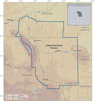
The Powder River Basin is a geologic structural basin in southeast Montana and northeast Wyoming, about 120 miles (190 km) east to west and 200 miles (320 km) north to south, known for its extensive coal reserves. The former hunting grounds of the Oglala Lakota, the area is very sparsely populated and is known for its rolling grasslands and semiarid climate.
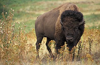
The Buffalo Commons is a conceptual proposal to create a vast nature preserve by returning 139,000 square miles (360,000 km2) of the drier portion of the Great Plains to native prairie, and by reintroducing the American bison ("buffalo"), that once grazed the shortgrass prairie. The proposal would affect ten states: Montana, Wyoming, Colorado, Oklahoma, New Mexico, Texas, North Dakota, South Dakota, Nebraska, and Kansas.

Custer National Forest is located primarily in the south central part of the U.S. state of Montana but also has separate sections in northwestern South Dakota. With a total area of 1,188,130 acres (4,808 km2), the forest comprises over 10 separate sections. While in the westernmost sections, Custer National Forest is a part of the Greater Yellowstone Ecosystem, the easternmost sections are a combination of forest "islands" and grasslands. A portion of the forest is also part of the Absaroka-Beartooth Wilderness and constitutes over a third of the wilderness land. South of Red Lodge, Montana, the Beartooth Highway passes through the forest en route to Yellowstone National Park.
This is a broad outline history of the state of Montana in the United States.

The Crow Indian Reservation is the homeland of the Crow Tribe. Established 1868, the reservation is located in parts of Big Horn, Yellowstone, and Treasure counties in southern Montana in the United States. The Crow Tribe has an enrolled membership of approximately 11,000, of whom 7,900 reside in the reservation. 20% speak Crow as their first language.

Interstate 90 (I-90) is an east–west transcontinental Interstate Highway across the northern United States, linking Seattle to Boston. The portion in the state of Montana is 552.46 miles (889.10 km) in length, passing through fourteen counties in central and southern Montana. Due to the large size of Montana, it is the longest segment of I-90 within a single state.

There is evidence of prehistoric human habitation in the region known today as the U.S. state of Wyoming stretching back roughly 13,000 years. Stone projectile points associated with the Clovis, Folsom and Plano cultures have been discovered throughout Wyoming. Evidence from what is now Yellowstone National Park indicates the presence of vast continental trading networks since around 1,000 years ago.

Montana is one of the eight Mountain States, located in the north of the region known as the Western United States. It borders North Dakota and South Dakota to the east. Wyoming is to the south, Idaho is to the west and southwest, and the Canadian provinces of British Columbia, Alberta, and Saskatchewan are to the north, making it the only state to border three Canadian provinces.
The Regional designations of Montana vary widely within the U.S state of Montana. The state is a large geographical area that is split by the Continental Divide, resulting in watersheds draining into the Pacific Ocean, Gulf of Mexico and Hudson's Bay. The state is approximately 545 miles (877 km) east to west along the Canada–United States border and 320 miles (510 km) north to south. The fourth largest state in land area, it has been divided up in official and unofficial ways into a variety of regions. Additionally, Montana is part of a number of larger federal government administrative regions.

American Prairie is a prairie-based nature reserve in Central Montana being developed as a private project of the American Prairie Foundation (APF). This independent non-profit organization is creating a wildlife conservation area that aims to cover over 3 million acres (12,000 km2) through a combination of both private and public lands to restore a mixed grass prairie ecosystem with migration corridors and native wildlife.
Margaret "Margie" MacDonald is an American politician who served as a member of the Montana Senate for the 26th district from 2017 to 2021. She previously served four terms in the Montana House of Representatives, representing the 54th and 51st district. She also served as Democratic minority whip in both chambers of the legislature.

Petroleum County is a county in the U.S. state of Montana. As of the 2020 census, the population was 496, making it the least populous county in Montana and the eighth-least populous in the United States. Its county seat is Winnett. The county's area was partitioned from Fergus County in 1925 to become the last of Montana's 56 counties to be organized.

In June 2022, the U.S. state of Montana was hit by heavy, damaging floods in multiple major watersheds including the Yellowstone River. Heavy rain and melting snow over the weekend June 10–13 caused large areas of Yellowstone National Park to be evacuated. On June 14, the water plant in Billings was temporarily shut down. Many houses were damaged as a result, and a number of roads and bridges were destroyed by floodwaters.
References
- 1 2 Bass, Thomas (July 1976). "Moving Gary, Indiana, to the Great Plains". Mother Jones. pp. 34–38.
- ↑ Allison, James Robert (2015). Sovereignty for Survival: American Energy Development and Indian Self-Determination. Yale University Press. p. 81. ISBN 978-0-300-20669-2.