Ukrainian is an East Slavic language. It is the official state language of Ukraine, one of the three official languages in the unrecognized state of Transnistria, the other two being Romanian and Russian. Written Ukrainian uses a variant of the Cyrillic script.
Hungarian is a Finno-Ugric language spoken in Hungary and parts of several neighbouring countries. It is the official language of Hungary and one of the 24 official languages of the European Union. Outside Hungary it is also spoken by communities of Hungarians in the countries that today make up Slovakia, western Ukraine (Subcarpathia), central and western Romania (Transylvania), northern Serbia (Vojvodina), northern Croatia and northern Slovenia. It is also spoken by Hungarian diaspora communities worldwide, especially in North America and Israel. Like Finnish and Estonian, Hungarian belongs to the Uralic language family. With 13 million speakers, it is the family's largest member by number of speakers.
Russian is an East Slavic language, which is official in the Russian Federation, Belarus, Kazakhstan and Kyrgyzstan, as well as being widely used throughout Eastern Europe, the Baltic states, the Caucasus and Central Asia. It was the de facto language of the Soviet Union until its dissolution on 25 December 1991. Although nearly three decades have passed since the breakup of the Soviet Union, Russian is used in official capacity or in public life in all the post-Soviet nation-states, as well as in Israel and Mongolia.
It lies in a plain beneath the Palanok Castle near the foothills of the Carpathian Mountains. Historically, it was part of the Kingdom of Hungary from the 11th century until 1918, when it was called Uj-Dávidháza, meaning "David's new home." It was located in Bereg megyé (county) and Munkácsi járás (district). It then became part of Czechoslovakia (1918-1938), when the region was referred to as Podkarpatská Rus (Sub-Carpathia), and the town was called Nové Davidkovo. The region reverted to Hungary during World War II, and then was annexed to the Soviet Union, in 1945, until Ukrainian independence in 1991. Today, it is part of Mukachevo Raion and the Zakarpattia Oblast of Ukraine.
The Palanok Castle or Mukachevo Castle is a historic castle in the city of Mukacheve in the western Ukrainian oblast (province) of Zakarpattia. The Palanok Castle is delicately preserved, and is located on a former 68 metre high volcanic hill. The castle complex consists of three parts: the high, middle, and low castle.
The Carpathian Mountains or Carpathians are a mountain range system forming an arc roughly 1,500 km (932 mi) long across Central and Eastern Europe, making them the third-longest mountain range in Europe after the Ural Mountains with 2,500 km (1,553 mi) and Scandinavian Mountains with 1,700 km (1,056 mi).
The Kingdom of Hungary was a monarchy in Central Europe that existed from the Middle Ages into the 20th century. The Principality of Hungary emerged as a Christian kingdom upon the coronation of the first king Stephen I at Esztergom around the year 1000; his family led the monarchy for 300 years. By the 12th century, the kingdom became a European middle power within the Western world.
Other spellings/names for Nove Davydkovo are: Novoye Davydkovo, Nove Davydkove and Nowe Dawydkowo. In Yiddish, it was referred to as Greis Davidkif.
Nove Davydkovo is located about 4 miles West of Mukacheve.
A geographic coordinate system is a coordinate system that enables every location on Earth to be specified by a set of numbers, letters or symbols. The coordinates are often chosen such that one of the numbers represents a vertical position and two or three of the numbers represent a horizontal position; alternatively, a geographic position may be expressed in a combined three-dimensional Cartesian vector. A common choice of coordinates is latitude, longitude and elevation. To specify a location on a plane requires a map projection.
This page is based on this Wikipedia article Text is available under the CC BY-SA 4.0 license; additional terms may apply. Images, videos and audio are available under their respective licenses.
Related Research Articles
Carpathian Ruthenia, Carpatho-Ukraine or Zakarpattia is a historic region in the border between Central and Eastern Europe, mostly located in western Ukraine's Zakarpattia Oblast, with smaller parts in easternmost Slovakia and Poland's Lemkovyna. Before World War I most of this region was part of the Kingdom of Hungary. In the interwar period, it was part of the First and Second Czechoslovak Republic. During World War II, the region was annexed by the Kingdom of Hungary once again. After the war, it became part of Soviet Ukraine.
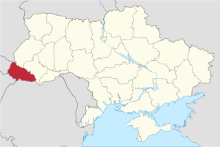
The Zakarpattia Oblast is an administrative oblast (province) located in southwestern Ukraine, coterminous with the historical region of Carpathian Ruthenia. Its administrative centre is the city of Uzhhorod. Other major cities within the oblast include Mukachevo, Khust, Berehove and Chop which is home to railroad transport infrastructure.
Mukachevo is a city located in the valley of the Latorica river in Zakarpattia Oblast (province), in Western Ukraine. Serving as the administrative center of Mukachevo Raion (district), the city itself does not belong to the raion and is designated as a city of oblast significance, with the status equal to that of a separate raion. The population is 86,339 (2016 est.).
Eastern European Time (EET) is one of the names of UTC+02:00 time zone, 2 hours ahead of Coordinated Universal Time. The zone uses daylight saving time, so that it uses UTC+03:00 during the summer.
Zakarpattia may refer to:
Chop is a city located in Zakarpattia Oblast (province) of western Ukraine, near the borders of Slovakia and Hungary. It is separated from the Hungarian town of Záhony by the river Tisza by being situated on its right bank. Located inside Uzhhorod Raion, since 2003 it is designated as a city of oblast significance - not included in any raion (district) of the oblast. Population: 8,937 (2016 est.).
Kuzmyno, also referred to as Kalnik, Kuzmics, Kuzmino, Kuzmina, Kuz'myno, or in Hungarian: Beregszilvás, is a village located in the Mukacheve Raion (district) in the Zakarpattia Oblast (province) in western Ukraine.
Uzhhorod Raion is one of the raions (districts) of Zakarpattia Oblast in western Ukraine. Its administrative center is located in the city of Uzhhorod which does not belong to the raion and is designated as a separate city municipality. Over 30% of population in the raion speak the Hungarian language according to the latest census. Population: 70,678 (2016 est.).
The Hungarians in Ukraine number 156,600 people according to the Ukrainian census of 2001 and are the fifth largest national minority in the country. They are the seventh biggest Hungarian diaspora in the World. Hungarians are largely concentrated in the Zakarpattia Oblast where they form the largest minority at 12.1% of the population. In the area along the Ukrainian border with Hungary, Hungarians form the majority.
Berehove Raion is a district (raion) in Zakarpattia Oblast (province) in the westernmost corner of Ukraine. The administrative center is Berehove, which does not belong to the raion and is incorporated separately as a city of oblast significance. For many centuries the territory of the district was part of Bereg County. Population: 51,391 (2016 est.).
Chynadiyovo is an urban-type settlement in Mukacheve Raion of Zakarpattia Oblast, Ukraine. It stands in the Latorica River valley, 10 km from the town of Mukacheve. Population: 6,940 (2016 est.).
Kliucharky is a village in Ukraine located about 4 miles south west of Mukacheve in Zakarpattia Oblast. Other spellings/names for Klyucharki are: Kluĉárky, Kljucsarki, Klyucharky, and Pavsino. In Yiddish, Kliucharky was referred to as Klicherkes. In 2001, its population was 2,632.
Chabanivka [pronounced Tscha-ba-novka] is a village in Uzhhorod Raion, Zakarpattia Oblast, Ukraine.
Stare Davydkovo is a small farming village in the suburbs of Mukachevo (Munkács) in Zakarpattia Oblast, Ukraine. Historically, it was part of the Kingdom of Hungary from the 11th century until 1918, when it was called Ó-Dávidháza. The administrative district center was in the nearby village of Palanok and all events of birth, marriage and death were recorded there.
Mizhhiria is an urban-type settlement in Zakarpattia Oblast (province) in western Ukraine. The town is also the administrative center of Mizhhirya Raion (district), housing the district's local administration buildings. The town's population was 9,656 as of the 2001 Ukrainian Census. Current population: 9,607 (2016 est.).
Zavydovo ) is a village of approximately 1,700 people in the Mukacheve Raion of Zakarpattia Oblast (province) in western Ukraine. The village is located approximately 20 kilometres (12 mi) from the city of Mukachevo.
Velyka Dobron is a village in Zakarpattia Oblast (province) of western Ukraine.
Hat' is a village in Zakarpattia Oblast (province) of western Ukraine. It is located approximately 12 kilometres (7.5 mi) northwest of Berehove, and 16 kilometres (9.9 mi) southwest of Mukachevo. Administratively, the village belongs to the Berehove Raion, Zakarpattia Oblast. Historically, the village was first mentioned as Gath in 1374.
Nehrovo is a village in Ukraine's Zakarpattia Oblast. It is 11 miles southeast of Mukachevo, which is the nearest town with a substantial population. It is located in the Irshava Raion (district).
Solovka is a railway station that is located in a village of Solovka, Uzhhorod Raion in Zakarpattia Oblast. It is part of the Uzhhorod administration. The station became a border crossing when the checkpoint was transferred from Batievo to Solovka that is located closer to the border.