
Noville Peninsula ( 71°50′S98°46′W / 71.833°S 98.767°W ) is a high ice-covered peninsula about 30 nautical miles (56 km; 35 mi) long, between Peale Inlet and Murphy Inlet on the north side of Thurston Island, Antarctica. [1]
Noville Peninsula ( 71°50′S98°46′W / 71.833°S 98.767°W ) is a high ice-covered peninsula about 30 nautical miles (56 km; 35 mi) long, between Peale Inlet and Murphy Inlet on the north side of Thurston Island, Antarctica. [1]

The Noville Peninsula extends north from the center of the north shore of Thurston Island. Glacier Bight is to its west, and Porters Pinnacles are just offshore to the north. Peale Inlet defines its west side and Murphy Inlet defines its east side. Mount Hawthorne in the Walker Mountains defines the south end of the peninsula. [2]
Noville Peninsula was delineated from aerial photographs made by United States Navy Operation Highjump in December 1946. It was named for George Otto Noville, executive officer of the Byrd Antarctic Expedition, 1933–35. [1]
71°33′S99°09′W / 71.550°S 99.150°W . A group of low ice-covered rocks forming a menace to navigation along the north coast of Thurston Island, located about 4 nautical miles (7.4 km; 4.6 mi) north of the east extremity of Glacier Bight. Discovered by the United States Navy Bellingshausen Sea Expedition in February 1960, and named for Commander Philip W. Porter, Jr., United States Navy, commander of the icebreaker USS Glacier which made this discovery. [3]
71°44′00″S98°46′00″W / 71.7333333°S 98.7666667°W . The ice-covered north extremity of Noville Peninsula, which is also the northernmost point of Thurston Island. Named by United States Advisory Committee on Antarctic Names (US-ACAN) after Lieutenant Ralph P. LeBlanc, U.S. Navy Reserve, plane commander of the Operation Highjump PBM Mariner seaplane that crashed 8 nautical miles (15 km; 9.2 mi) south of this cape on December 30, 1946. Severely injured, LeBlanc was among six of nine aboard that survived the crash. The survivors were rescued January 12, 1947 by Lieutenant Commander John D. Howell, who landed a PBM in open water off the northwest edge of Noville Peninsula. [4]
71°54′S99°09′W / 71.9°S 99.15°W . An ice-covered point forming the west extremity of Noville Peninsula. So named in remembrance of the Mariner seaplane crash on the peninsula during United States Navy Operation Highjump, and that six survivors were rescued near this point on January 12, 1947 (see also Ball Peninsula, Mount Howell). [5]
71°40′S98°52′W / 71.667°S 98.867°W . An ice-covered mountain, visible from seaward, surmounting the north end of Noville Peninsula on Thurston Island. Delineated from aerial photographs taken by United States Navy in December 1946. Named by US-ACAN for James Troxall Palmer, acting surgeon on the ship Relief and later on the sloop of war Peacock of the USEE under Wilkes, 1838-42, and later Surgeon-General of the Navy. [6]
71°46′S98°06′W / 71.767°S 98.100°W . A small steep cliff rock exposure at the northeast end of Noville Peninsula. The feature is just south of small Mulroy Island. Delineated from aerial photographs taken by United States Navy Squadron VX-6 in January 1960. Named by US-ACAN for George H. Black, supply officer of the ByrdAE in 1928-30. [7]
71°44′S98°26′W / 71.733°S 98.433°W . A mountain between Sikorski Glacier and Frankenfield Glacier on the northeast side of the Noville Peninsula. First delineated from air photos taken by United States Navy Noville Peninsula. Named by US-ACAN for James Feury, mechanic and snowmobile driver of the ByrdAE, 1928-30. [8]

Carney Island is an ice-covered island, 70 nautical miles long with all but its north coast lying within the Getz Ice Shelf, Antarctica. It is located between Siple Island and Wright Island along the coast of Marie Byrd Land.

Thurston Island is a largely ice-covered, glacially dissected island, 135 nautical miles long and 55 nautical miles wide, lying between between Amundsen Sea and Bellingshausen Sea a short way off the northwest end of Ellsworth Land, Antarctica. The island is separated from the mainland by Peacock Sound, which is occupied by the west portion of Abbot Ice Shelf.
The Scaife Mountains is a group of mountains rising west of Prehn Peninsula and between the Ketchum Glacier and Ueda Glacier, at the base of the Antarctic Peninsula.
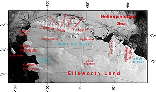
The Abbot Ice Shelf is an ice shelf 250 nautical miles long and 40 nautical miles wide, bordering Eights Coast from Cape Waite to Pfrogner Point in Antarctica. Thurston Island lies along the northern edge of the western half of this ice shelf; other sizable islands lie partly or wholly within this shelf.

Bear Peninsula is a peninsula about 50 nautical miles long and 25 nautical miles wide which is ice-covered except for several isolated rock bluffs and outcrops along its margins, lying 3 nautical miles east of Martin Peninsula on Walgreen Coast, Marie Byrd Land, Antarctica.
Martin Peninsula is a peninsula about 60 nautical miles long and 20 nautical miles wide that is ice-covered except for a few rock outcrops along its margins, located between Getz Ice Shelf and Dotson Ice Shelf on the coast of Marie Byrd Land, Antarctica. The farthest point of the peninsula is Jacobsen Head.

The Getz Ice Shelf is an ice shelf over 300 nautical miles long and from 20 to 60 nautical miles wide, bordering the Hobbs Coast and Bakutis Coast of Marie Byrd Land, Antarctica, between the McDonald Heights and Martin Peninsula. Several large islands are partially or wholly embedded in the ice shelf.
Odom Inlet is an ice-filled inlet 9 nautical miles long, between Cape Howard and Cape MacDonald along the east coast of Palmer Land, Antarctica.
The Walker Mountains are a range of peaks and nunataks which are fairly well separated but trend east–west to form the axis, or spine, of Thurston Island in Antarctica.
King Peninsula is an ice-covered peninsula, 100 nautical miles long and 20 nautical miles wide, lying south of Thurston Island and forming the south side of Peacock Sound, Antarctica. It projects from the continental ice sheet and trends west between the Abbot Ice Shelf and Cosgrove Ice Shelf to terminate at the Amundsen Sea.
Canisteo Peninsula is an ice-covered peninsula, about 30 nautical miles long and 20 nautical miles wide, which projects between Ferrero Bay and Cranton Bay into the eastern extremity of the Amundsen Sea.
Sulzberger Bay is a bay indenting the front of the Sulzberger Ice Shelf between Fisher Island and Vollmer Island, along the coast of Marie Byrd Land, Antarctica.

The Sikorski Glacier is a small glacier in the north-eastern part of the Noville Peninsula, Thurston Island, Ellsworth Land, Antarctica. It flows north-east to the Bellingshausen Sea between Mount Palmer and Mount Feury. It was first roughly delineated from aerial photos taken by the USN's Operation Highjump in 1946–47. It was named by the Advisory Committee on Antarctic Names (US-ACAN) for Stephen Sikorski, electronics technician on USS Glacier, who assisted in setting up an automatic weather station on Thurston Island during the USN's Bellingshausen Sea Expedition in February 1960.
Bowman Inlet is an ice-filled inlet between Kay Nunatak and Platt Point on the Hollick-Kenyon Peninsula, on the east coast of the Antarctic Peninsula.
Condor Peninsula is a mountainous, ice-covered peninsula, 30 nautical miles long and 10 to 15 nautical miles wide, between Odom Inlet and Hilton Inlet on the east coast of Palmer Land, Antarctica.
Cranton Bay is a bay about 20 nautical miles long and wide, lying south of the Canisteo Peninsula, Antarctica, at the eastern end of the Amundsen Sea. The southern limit of the bay is formed by the Backer Islands and an ice shelf which separates this bay from Pine Island Bay.
Lofgren Peninsula is an ice-covered peninsula about 22 nautical miles long, projecting between Cadwalader Inlet and Morgan Inlet on the northeast side of Thurston Island, Antarctica.
Hilton Inlet is an ice-filled inlet, 12 nautical miles wide, which recedes about 22 nautical miles west from its entrance between Cape Darlington and Cape Knowles, along the east coast of Palmer Land, Antarctica.
Lehrke Inlet is an ice-filled inlet, 8 nautical miles wide, which recedes southwest for 17 nautical miles between Cape Boggs and Cape Sharbonneau, along the east coast of Palmer Land, Antarctica.