Biały Dwór is a village in the administrative district of Gmina Lubowidz, within Żuromin County, Masovian Voivodeship, in east-central Poland.
Lusajny Małe is a settlement in the administrative district of Gmina Morąg, within Ostróda County, Warmian-Masurian Voivodeship, in northern Poland.

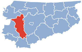
Dziadyk is a village in the administrative district of Gmina Ostróda, within Ostróda County, Warmian-Masurian Voivodeship, in northern Poland. It lies approximately 10 kilometres (6 mi) south of Ostróda and 39 km (24 mi) south-west of the regional capital Olsztyn.
Giętlewo is a village in the administrative district of Gmina Ostróda, within Ostróda County, Warmian-Masurian Voivodeship, in northern Poland. It lies approximately 19 kilometres (12 mi) south of Ostróda and 44 km (27 mi) south-west of the regional capital Olsztyn.
Jankowiec is a settlement in the administrative district of Gmina Ostróda, within Ostróda County, Warmian-Masurian Voivodeship, in northern Poland. It lies approximately 10 kilometres (6 mi) south of Ostróda and 41 km (25 mi) south-west of the regional capital Olsztyn.
Kajkowo is a village in the administrative district of Gmina Ostróda, within Ostróda County, Warmian-Masurian Voivodeship, in northern Poland. It lies approximately 4 kilometres (2 mi) south of Ostróda and 38 km (24 mi) west of the regional capital Olsztyn.
Lipowo is a village in the administrative district of Gmina Ostróda, within Ostróda County, Warmian-Masurian Voivodeship, in northern Poland. It lies approximately 15 kilometres (9 mi) south-west of Ostróda and 49 km (30 mi) south-west of the regional capital Olsztyn.
Międzylesie is a village in the administrative district of Gmina Ostróda, within Ostróda County, Warmian-Masurian Voivodeship, in northern Poland. It lies approximately 4 kilometres (2 mi) north-east of Ostróda and 34 km (21 mi) west of the regional capital Olsztyn.
Ornowo is a village in the administrative district of Gmina Ostróda, within Ostróda County, Warmian-Masurian Voivodeship, in northern Poland. It lies approximately 4 kilometres (2 mi) south of Ostróda and 39 km (24 mi) west of the regional capital Olsztyn.
Pietrzwałd is a village in the administrative district of Gmina Ostróda, within Ostróda County, Warmian-Masurian Voivodeship, in northern Poland. It lies approximately 14 kilometres (9 mi) south of Ostróda and 45 km (28 mi) south-west of the regional capital Olsztyn.
Pobórze is a settlement in the administrative district of Gmina Ostróda, within Ostróda County, Warmian-Masurian Voivodeship, in northern Poland. It lies approximately 12 kilometres (7 mi) west of Ostróda and 48 km (30 mi) west of the regional capital Olsztyn.
Reszki is a village in the administrative district of Gmina Ostróda, within Ostróda County, Warmian-Masurian Voivodeship, in northern Poland. It lies approximately 13 kilometres (8 mi) south-west of Ostróda and 48 km (30 mi) south-west of the regional capital Olsztyn.
Rudno is a village in the administrative district of Gmina Ostróda, within Ostróda County, Warmian-Masurian Voivodeship, in northern Poland. It lies approximately 10 kilometres (6 mi) south of Ostróda and 41 km (25 mi) south-west of the regional capital Olsztyn.
Samborowo is a village in the administrative district of Gmina Ostróda, within Ostróda County, Warmian-Masurian Voivodeship, in northern Poland. It lies approximately 11 kilometres (7 mi) west of Ostróda and 47 km (29 mi) west of the regional capital Olsztyn.
Smykowo is a village in the administrative district of Gmina Ostróda, within Ostróda County, Warmian-Masurian Voivodeship, in northern Poland. It lies approximately 9 kilometres (6 mi) south-west of Ostróda and 42 km (26 mi) south-west of the regional capital Olsztyn.
Turznica is a village in the administrative district of Gmina Ostróda, within Ostróda County, Warmian-Masurian Voivodeship, in northern Poland. It lies approximately 10 kilometres (6 mi) south-west of Ostróda and 46 km (29 mi) west of the regional capital Olsztyn.
Wirwajdy is a village in the administrative district of Gmina Ostróda, within Ostróda County, Warmian-Masurian Voivodeship, in northern Poland. It lies approximately 8 kilometres (5 mi) south-west of Ostróda and 44 km (27 mi) west of the regional capital Olsztyn.
Wysoka Wieś is a village in the administrative district of Gmina Ostróda, within Ostróda County, Warmian-Masurian Voivodeship, in northern Poland. It lies approximately 17 kilometres (11 mi) south of Ostróda and 45 km (28 mi) south-west of the regional capital Olsztyn.
Zajączki is a village in the administrative district of Gmina Ostróda, within Ostróda County, Warmian-Masurian Voivodeship, in northern Poland. It lies approximately 17 kilometres (11 mi) south of Ostróda and 48 km (30 mi) south-west of the regional capital Olsztyn.