Bronkowice is a village in the administrative district of Gmina Pawłów, within Starachowice County, Świętokrzyskie Voivodeship, in south-central Poland. It lies approximately 8 kilometres (5 mi) west of Pawłów, 9 km (6 mi) south-west of Starachowice, and 31 km (19 mi) east of the regional capital Kielce.
Brzezie is a village in the administrative district of Gmina Pawłów, within Starachowice County, Świętokrzyskie Voivodeship, in south-central Poland. It lies approximately 6 kilometres (4 mi) south-west of Pawłów, 13 km (8 mi) south of Starachowice, and 32 km (20 mi) east of the regional capital Kielce.
Chybice is a village in the administrative district of Gmina Pawłów, within Starachowice County, Świętokrzyskie Voivodeship, in south-central Poland. It lies approximately 5 kilometres (3 mi) south of Pawłów, 14 km (9 mi) south of Starachowice, and 35 km (22 mi) east of the regional capital Kielce.
Dąbrowa is a village in the administrative district of Gmina Pawłów, within Starachowice County, Świętokrzyskie Voivodeship, in south-central Poland. It lies approximately 3 kilometres (2 mi) east of Pawłów, 10 km (6 mi) south-east of Starachowice, and 39 km (24 mi) east of the regional capital Kielce.
Godów is a village in the administrative district of Gmina Pawłów, within Starachowice County, Świętokrzyskie Voivodeship, in south-central Poland. It lies approximately 5 kilometres (3 mi) east of Pawłów, 13 km (8 mi) south-east of Starachowice, and 41 km (25 mi) east of the regional capital Kielce.
Jadowniki is a village in the administrative district of Gmina Pawłów, within Starachowice County, Świętokrzyskie Voivodeship, in south-central Poland. It lies approximately 4 kilometres (2 mi) south-west of Pawłów, 12 km (7 mi) south of Starachowice, and 34 km (21 mi) east of the regional capital Kielce.
Łomno is a village in the administrative district of Gmina Pawłów, within Starachowice County, Świętokrzyskie Voivodeship, in south-central Poland. It lies approximately 8 kilometres (5 mi) south-west of Pawłów, 16 km (10 mi) south of Starachowice, and 31 km (19 mi) east of the regional capital Kielce.
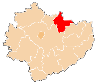
Pawłów is a village in Starachowice County, Świętokrzyskie Voivodeship, in south-central Poland. It is the seat of the gmina called Gmina Pawłów. It lies approximately 10 kilometres (6 mi) south of Starachowice and 36 km (22 mi) east of the regional capital Kielce.
Pokrzywnica is a village in the administrative district of Gmina Pawłów, within Starachowice County, Świętokrzyskie Voivodeship, in south-central Poland. It lies approximately 5 kilometres (3 mi) south-east of Pawłów, 15 km (9 mi) south of Starachowice, and 38 km (24 mi) east of the regional capital Kielce.
Rzepin Pierwszy is a village in the administrative district of Gmina Pawłów, within Starachowice County, Świętokrzyskie Voivodeship, in south-central Poland. It lies approximately 3 kilometres (2 mi) north-west of Pawłów, 8 km (5 mi) south of Starachowice, and 35 km (22 mi) east of the regional capital Kielce.
Rzepinek is a village in the administrative district of Gmina Pawłów, within Starachowice County, Świętokrzyskie Voivodeship, in south-central Poland. It lies approximately 4 kilometres (2 mi) west of Pawłów, 10 km (6 mi) south of Starachowice, and 32 km (20 mi) east of the regional capital Kielce.
Stary Bostów is a village in the administrative district of Gmina Pawłów, within Starachowice County, Świętokrzyskie Voivodeship, in south-central Poland. It lies approximately 7 kilometres (4 mi) south of Pawłów, 16 km (10 mi) south of Starachowice, and 33 km (21 mi) east of the regional capital Kielce.

Świętomarz is a village in the administrative district of Gmina Pawłów, within Starachowice County, Świętokrzyskie Voivodeship, in south-central Poland. It lies approximately 7 kilometres (4 mi) south-west of Pawłów, 14 km (9 mi) south of Starachowice, and 30 km (19 mi) east of the regional capital Kielce.
Świślina is a village in the administrative district of Gmina Pawłów, within Starachowice County, Świętokrzyskie Voivodeship, in south-central Poland. It lies approximately 5 kilometres (3 mi) west of Pawłów, 10 km (6 mi) south of Starachowice, and 32 km (20 mi) east of the regional capital Kielce.
Szeligi is a village in the administrative district of Gmina Pawłów, within Starachowice County, Świętokrzyskie Voivodeship, in south-central Poland. It lies approximately 6 kilometres (4 mi) east of Pawłów, 14 km (9 mi) south-east of Starachowice, and 41 km (25 mi) east of the regional capital Kielce.
Szerzawy is a village in the administrative district of Gmina Pawłów, within Starachowice County, Świętokrzyskie Voivodeship, in south-central Poland. It lies approximately 6 kilometres (4 mi) west of Pawłów, 12 km (7 mi) south of Starachowice, and 31 km (19 mi) east of the regional capital Kielce.
Trzeszków is a village in the administrative district of Gmina Pawłów, within Starachowice County, Świętokrzyskie Voivodeship, in south-central Poland. It lies approximately 5 kilometres (3 mi) south of Pawłów, 15 km (9 mi) south of Starachowice, and 36 km (22 mi) east of the regional capital Kielce.
Warszówek is a village in the administrative district of Gmina Pawłów, within Starachowice County, Świętokrzyskie Voivodeship, in south-central Poland. It lies approximately 2 kilometres (1 mi) south of Pawłów, 11 km (7 mi) south of Starachowice, and 36 km (22 mi) east of the regional capital Kielce.
Wawrzeńczyce is a village in the administrative district of Gmina Pawłów, within Starachowice County, Świętokrzyskie Voivodeship, in south-central Poland. It lies approximately 5 kilometres (3 mi) south of Pawłów, 14 km (9 mi) south of Starachowice, and 35 km (22 mi) east of the regional capital Kielce.
Wieloborowice is a village in the administrative district of Gmina Pawłów, within Starachowice County, Świętokrzyskie Voivodeship, in south-central Poland. It lies approximately 6 kilometres (4 mi) south of Pawłów, 16 km (10 mi) south of Starachowice, and 37 km (23 mi) east of the regional capital Kielce.