| Tarczek | |
|---|---|
| Village | |
Church from the 13th century in Tarczek | |
 Tarczek | |
| Coordinates: 50°56′35″N21°0′12″E / 50.94306°N 21.00333°E | |
| Country | |
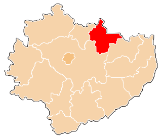
| Voivodeship | Świętokrzyskie |
| County | Starachowice |
| Gmina | Pawłów |
| Population | 590 |
Tarczek [ˈtart͡ʂɛk] is a village in the administrative district of Gmina Pawłów, within Starachowice County, Świętokrzyskie Voivodeship, in south-central Poland. It lies approximately 8 kilometres (5 mi) west of Pawłów, 13 km (8 mi) south of Starachowice, and 28 km (17 mi) east of the regional capital Kielce. [1] The village has a population of 590.

A village is a clustered human settlement or community, larger than a hamlet but smaller than a town, with a population ranging from a few hundred to a few thousand. Though villages are often located in rural areas, the term urban village is also applied to certain urban neighborhoods. Villages are normally permanent, with fixed dwellings; however, transient villages can occur. Further, the dwellings of a village are fairly close to one another, not scattered broadly over the landscape, as a dispersed settlement.
Gmina Pawłów is a rural gmina in Starachowice County, Świętokrzyskie Voivodeship, in south-central Poland. Its seat is the village of Pawłów, which lies approximately 10 kilometres (6 mi) south of Starachowice and 36 km (22 mi) east of the regional capital Kielce.
Starachowice County is a unit of territorial administration and local government (powiat) in Świętokrzyskie Voivodeship, south-central Poland. It came into being on January 1, 1999, as a result of the Polish local government reforms passed in 1998. Its administrative seat and largest town is Starachowice, which lies 37 kilometres (23 mi) north-east of the regional capital Kielce. The only other town in the county is Wąchock, lying 5 km (3 mi) north-west of Starachowice.
Tarczek lies on the Psarka river, among the hills of Gory Swietokrzyskie, north of Lysogory. The village is divided into two parts: Lower Tarczek (Tarczek Dolny), and Upper Tarczek (Tarczek Gorny). It has the parish church of Saint Giles. The village is located along regional road 752, which goes from Starachowice to Kielce.

Saint Giles, also known as Giles the Hermit, was a Greek, Christian, hermit saint from Athens, whose legend is centered in Provence and Septimania. Giles founded the abbey in Saint-Gilles-du-Gard whose tomb became a place of pilgrimage. It was a stop on the road that led from Arles to Santiago de Compostela, the pilgrim Way of St. James. Giles is one of the Fourteen Holy Helpers.

Kielce is a city in south central Poland with 196,335 inhabitants. It has been the capital city of the Świętokrzyskie Voivodeship since 1999, and was previously the capital of the predecessor Kielce Voivodeship. The city is located in the middle of the Świętokrzyskie Mountains, on the banks of the Silnica River, in northern part of the historical Polish province of Lesser Poland.
In the Middle Ages, Tarczek belonged to the Bishops of Kraków, who had a manor house here, together with a church, erected in 1067 by Wladyslaw Herman, as a votum for the birth of his son Boleslaw Krzywousty. In 1227, Bishop Iwo Odrowaz, with permission of Prince of Sandomierz Leszek I the White allowed German settlers (see Ostsiedlung) to come and settle in the area of Tarczek. The village was granted Magdeburg rights in the year 1259, and was the seat of a castellan. It was a trade center of local importance, together with such towns, as Iłża and Wierzbica. In 1244, Tarczek was destroyed by Prince Konrad I of Masovia, and in 1268, it was burned in a Lithuanian raid. In the late 13th century, with permission of King Wenceslaus II of Bohemia, Tarczek was surrounded by a defensive wall.

In the history of Europe, the Middle Ages lasted from the 5th to the 15th century. It began with the fall of the Western Roman Empire and merged into the Renaissance and the Age of Discovery. The Middle Ages is the middle period of the three traditional divisions of Western history: classical antiquity, the medieval period, and the modern period. The medieval period is itself subdivided into the Early, High, and Late Middle Ages.

In ancient Roman religion, a votum, plural vota, is a vow or promise made to a deity. The word comes from the past participle of the Latin verb voveo, vovere, "vow, promise". As the result of this verbal action, a votum is also that which fulfills a vow, that is, the thing promised, such as offerings, a statue, or even a temple building. The votum is thus an aspect of the contractual nature of Roman religion, a bargaining expressed by do ut des, "I give that you might give."

Ostsiedlung, in English called the German eastward expansion, was the medieval eastward migration and settlement of Germanic-speaking peoples from the Holy Roman Empire, especially its southern and western portions, into less-populated regions of Central Europe, parts of west Eastern Europe, and the Baltics. The affected area roughly stretched from Estonia in the north all the way to Slovenia in the south and extended into Transylvania, modern-day Romania in the east. In part, Ostsiedlung followed the territorial expansion of the Empire and the Teutonic Order.
In the mid 14th century, Bishop of Kraków Jan Bodzanta founded the town of Bodzentyn, located five kilometers from Tarczek. The bishop moved the market place and the castellany to Bodzentyn, after which Tarczek lost its importance and in 1412 was stripped of town charter. In the 15th century, Jan Długosz wrote that Tarczek used to be an important town of the bishops (oppidum notabile). Until the Partitions of Poland, the village was part of Lesser Poland's Sandomierz Voivodeship, and in 1815–1915, it belonged to Russian-controlled Congress Poland.

Bodzentyn(
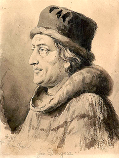
Jan Długosz, also known as Ioannes, Joannes, or Johannes Longinus or Dlugossius, was a Polish priest, chronicler, diplomat, soldier, and secretary to Bishop Zbigniew Oleśnicki of Kraków. He is considered Poland's first historian.

The Partitions of Poland were three partitions of the Polish–Lithuanian Commonwealth that took place toward the end of the 18th century and ended the existence of the state, resulting in the elimination of sovereign Poland and Lithuania for 123 years. The partitions were conducted by Habsburg Austria, the Kingdom of Prussia, and the Russian Empire, which divided up the Commonwealth lands among themselves progressively in the process of territorial seizures and annexations.
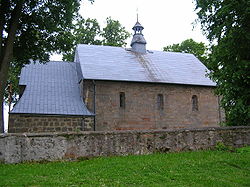
Main object of interest in the village is Romanesque church of Saint Giles from the first half of the 13th century, built in the location of the earlier church from 1067. It has one nave, and the church is made from limestone, with Romanesque walls, except for Western facade, which was rebuilt in the 16th century. In the southern wall of the presbytery there is a late Gothic portal. Gothic vault was rebuilt after World War II. Inside the church there are remains of a late Renaissance polychrome, a Gothic relief, a Renaissance triptych (1540), a Romanesque baptismal font, and a Baroque pulpit. The church was partly destroyed in the Swedish invasion of Poland. In the parish cemetery there are two 300-year-old tilias.

Romanesque architecture is an architectural style of medieval Europe characterized by semi-circular arches. There is no consensus for the beginning date of the Romanesque style, with proposals ranging from the 6th to the 11th century, this later date being the most commonly held. In the 12th century it developed into the Gothic style, marked by pointed arches. Examples of Romanesque architecture can be found across the continent, making it the first pan-European architectural style since Imperial Roman architecture. The Romanesque style in England is traditionally referred to as Norman architecture.

The nave is the central part of a church, stretching from the main entrance or rear wall, to the transepts, or in a church without transepts, to the chancel. When a church contains side aisles, as in a basilica-type building, the strict definition of the term 'nave' is restricted to the central aisle. In a broader, more colloquial sense, the nave includes all areas available for the lay worshippers, including the side-aisles and transepts. Either way, the nave is distinct from the area reserved for the choir and clergy.

Limestone is a sedimentary rock which is often composed of the skeletal fragments of marine organisms such as coral, foraminifera, and molluscs. Its major materials are the minerals calcite and aragonite, which are different crystal forms of calcium carbonate (CaCO3).


