
State Route 1 (SR 1) is a major north–south state highway that runs along most of the Pacific coastline of the U.S. state of California. At 656 miles (1,056 km), it is the longest state route in California, and the second-longest in the US after Montana Highway 200. SR 1 has several portions designated as either Pacific Coast Highway (PCH), Cabrillo Highway, Shoreline Highway, or Coast Highway. Its southern terminus is at Interstate 5 (I-5) near Dana Point in Orange County and its northern terminus is at U.S. Route 101 (US 101) near Leggett in Mendocino County. SR 1 also at times runs concurrently with US 101, most notably through a 54-mile (87 km) stretch in Ventura and Santa Barbara counties, and across the Golden Gate Bridge.

Mendocino County is a county located on the North Coast of the U.S. state of California. As of the 2020 census, the population was 91,601. The county seat is Ukiah.
Fort Bragg is a city along the North Coast of California along in Mendocino County. The city is 24 miles (39 km) west of Willits, at an elevation of 85 feet (26 m). Its population was 6,983 at the 2020 census.
Mendocino is an unincorporated community in Mendocino County, California, United States. The name comes from Cape Mendocino 85 miles (137 km) to the north, named by early Spanish navigators in honor of Antonio de Mendoza, Viceroy of New Spain. Despite its small size, the town's scenic location on a headland surrounded by the Pacific Ocean has made it extremely popular as an artists' colony and with vacationers.

The Eel River is a major river, about 196 miles (315 km) long, in northwestern California. The river and its tributaries form the third-largest watershed entirely in California, draining a rugged area of 3,684 square miles (9,540 km2) in five counties. The river flows generally northward through the Coast Ranges west of the Sacramento Valley, emptying into the Pacific Ocean about 10 miles (16 km) downstream from Fortuna and just south of Humboldt Bay. The river provides groundwater recharge, recreation, and industrial, agricultural and municipal water supply.
The California Western Railroad, AKA Mendocino Railway, popularly called the Skunk Train, is a rail freight and heritage railroad transport railway in Mendocino County, California, United States, running from the railroad's headquarters in the coastal town of Fort Bragg to the interchange with the Northwestern Pacific Railroad at Willits.

Area codes 707 and 369 are telephone area codes in the North American Numbering Plan (NANP) for the northwestern part of the U.S. state of California. The area codes serve part of the northern San Francisco Bay Area, as well as the North Coast. Major cities in the area codes include Napa, Sebastopol, Vallejo, Benicia, Fairfield, Santa Rosa, Windsor, Healdsburg, Rohnert Park, Petaluma, Fort Bragg, Rio Vista, Crescent City, Eureka, Clearlake, Vacaville, Dixon, and Ukiah. 707 was created by a split of area code 415 on March 1, 1959. Area code 369 was added to the numbering plan area (NPA) on February 1, 2023, to form an overlay numbering plan in the service area.
The West Coast lumber trade was a maritime trade route on the West Coast of the United States. It carried lumber from the coasts of Northern California, Oregon, and Washington mainly to the port of San Francisco. The trade included direct foreign shipment from ports of the Pacific Northwest and might include another product characteristic of the region, salmon, as in the schooner Henry Wilson sailing from Washington state for Australia with "around 500,000 feet of lumber and canned salmon" in 1918.

The Mendocino Range is one of several coastal mountain ranges which compose the Pacific Coast Range. This massive range of coastal mountains was formed during a period of coastal orogeny, millions of years ago. The Mendocino Range is a component of the California Coast Ranges of California. The Klamath Range is north of this region, and the Cascade Range runs to the northeast.

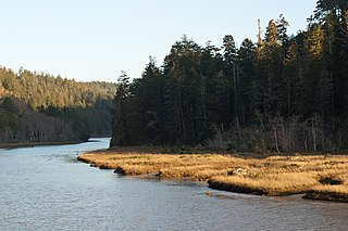
The Noyo River is a river on the north coast of California in Mendocino County. The river's headwaters are in the steep Mendocino Range, but downstream the river flows through gently sloping marine terraces before draining into the Pacific Ocean. The 113 square miles (290 km2) watershed extends east to the small city of Willits and the river's mouth is at Noyo Harbor in Fort Bragg, which uses the river for drinking water; it is neighbored on the south by Hare Creek and the Big River, on the east by the South Fork Eel River, and on the north by Ten Mile River, named for its distance from the Noyo River. The average annual rainfall is between 40 inches (1,000 mm) and 65 inches (1,700 mm).
The Big River is a 41.7-mile-long (67.1 km) river in Mendocino County, California, that flows from the northern California Coast Range to the Pacific Ocean at Mendocino, Mendocino County, California. From the mouth, brackish waters extend 8 miles (13 km) upstream, forming the longest undeveloped estuary in the state.
Noyo Harbor is the port and boat docking area for Fort Bragg, California, USA. It is built near the mouth of the Noyo River in the town of Noyo, just south of Fort Bragg. Noyo Harbor is located in Mendocino County 130 nautical miles (240 km) northwest of the Port of San Francisco and 145 nautical miles (269 km) south-southeast of the port of Crescent City, California. Highway 1 passes over the Noyo Bridge above the harbor.

MacKerricher State Park is a state park in California in the United States. It is located 3 miles (4.8 km) north of Fort Bragg in Mendocino County. It covers 9 miles (14 km) of coastline and contains several types of coastal habitat, including beaches, dunes, headlands, coves, wetlands, tide pools, forest, and a freshwater lake.

Russian Gulch State Park is a California State Park in coastal Mendocino County, California, 2 mi (3.2 km) north of Mendocino and 7 mi (11 km) south of Fort Bragg.

Jackson Demonstration State Forest is a public forest in Mendocino County, California managed by the California Department of Forestry and Fire Protection. It is the largest demonstration forest operated by the State of California. The forest land is located along California State Highway 20 between Willits and the coastal city of Fort Bragg. It is named after Jacob Green Jackson, founder of Caspar Lumber Company, which formerly owned the land. The forest holds sacred value as an ancestral home and ceremonial site for the Coyote Valley Band of Pomo Indians.

Redwood Empire Council is the local council of the Boy Scouts of America that serves youth in Mendocino and Sonoma counties in California.

Noyo is an unincorporated community in Mendocino County, California. It is located 1 mile (1.6 km) south of the center of Fort Bragg, at an elevation of 108 feet. It is named after the Noyo River, on which it lies; the Noyo River in turn was misnamed by white settlers to the Mendocino area after a village of the Pomo people named Noyo several miles north, on Pudding Creek. The Pomo named the creek after their village, and the settlers transferred the name to the larger river to the south.
Ten Mile River is in northern Mendocino County, California, United States. It is named for the fact that its mouth is 10 miles (16 km) north of the mouth of the Noyo River. The lands around lower Ten Mile River provide valuable freshwater and saltwater marsh habitat for a variety of birds. The Ten Mile River Estuary, Ten Mile Beach, and Ten Mile State Marine Reserve together form a marine protected area that extends from the estuary out to 5 nautical miles. Ten Mile Beach is also part of MacKerricher State Park, which extends approximately 5 miles (8.0 km) southward from the mouth of the river to Cleone and includes approximately 1,300 acres (526 ha) of the "most pristine stretch of sand dunes [in California]."
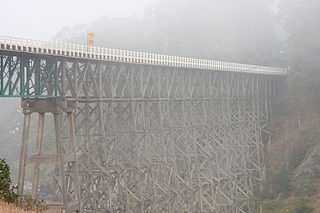
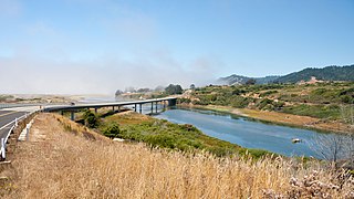
The Albion River Bridge is a wooden deck truss bridge crossing the Albion River in Mendocino County, California. It is the only remaining wooden bridge on California State Route 1; dramatic views of the bridge are visible from the nearby town of Albion, California. It was listed on the National Register of Historic Places in July 2017.

Hare Creek is a small stream in Mendocino County, California, just south of Fort Bragg. It is approximately 12.4 kilometres (7.7 mi) long and all but the final 1.14 miles (1.83 km) of its watercourse lies within Jackson Demonstration State Forest. With its four tributaries it drains an area of approximately 2,400 hectares (9.3 sq mi). Its watershed is bordered on the north by the Noyo River, and on the south by Digger Creek. It is a significant habitat for coho salmon. It meets the Pacific Ocean at Hare Creek Beach, also known as Babcock Beach, owned and operated by the Mendocino Land Trust.


