Nquthu | |
|---|---|
 Nquthu  Nquthu | |
| Coordinates: 28°13′55″S30°33′58″E / 28.232°S 30.566°E | |
| Country | South Africa |
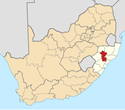
| Province | KwaZulu-Natal |
| District | Umzinyathi |
| Municipality | Nqutu |
| Area | |
• Total | 5.31 km2 (2.05 sq mi) |
| Population (2011) [1] | |
• Total | 170 307 |
| Racial makeup (2011) | |
| • Black African | 97.9% |
| • Coloured | 0.3% |
| • Indian/Asian | 0.2% |
| • White | 0.2% |
| • Other | 1.4% |
| First languages (2011) | |
| • Zulu | 91.5% |
| • Sotho | 1.6% |
| • English | 1.6% |
| • Other | 5.2% |
| Time zone | UTC+2 (SAST) |
Nquthu is a town in Umzinyathi District Municipality in the KwaZulu-Natal province of South Africa.
The village is 24 km west-south-west of Barklieside and 53 km east of Dundee, KwaZulu-Natal. Of Zulu origin, the name is derived from isquthu, which translates to 'flat-topped vessel', descriptive of a nearby hill from which the village takes its name. [2]