Talana, KwaZulu-Natal

Last updated
Talana
South Africa KwaZulu-Natal location map.svg
Red pog.svg
Talana
South Africa adm location map.svg
Red pog.svg
Talana
Coordinates: 28°10′41″S30°15′18″E / 28.178°S 30.255°E / -28.178; 30.255 Coordinates: 28°10′41″S30°15′18″E / 28.178°S 30.255°E / -28.178; 30.255
Country South Africa
Province KwaZulu-Natal
District Umzinyathi
Municipality Endumeni
Time zone UTC+2 (SAST)
PO box
3023

Talana is a village 5 km east of Dundee on the route between Vryheid and Glencoe. The name is Zulu and derives from the shelf, made of itala grass, around the central pole in a Zulu chief's home. Amulets, precious items and valuables were placed on this Talana Shelf. Hence the name means "the place where treasures are kept."

Dundee, KwaZulu-Natal Place in KwaZulu-Natal, South Africa

The coal mining town of Dundee is situated in a valley of the Biggarsberg mountains in KwaZulu-Natal, South Africa. It is part of the Endumeni Municipality, Umzinyathi District. It is very rich in coal deposits. More populous than the town of Dundee itself is its adjacent township named Sibongile. This township is now being extended with many residing zones, e.g. Lindelani. Dundee was originally established by Peter Smith, with land contributed by his son in-law. Dundee was established in 1882 after the realisation that the valley was a natural way for travellers into the interior of Africa. Traders, hunters explorers, missionaries and soldiers all made their way through here.A large fort, Fort Jones, housed British troops in the area during the Anglo Zulu War of 1879. The discovery of coal in the area dates from early Voortrekker records of 1838 and later geological surveys in the 1860s. It is named after the hometown of a pioneering Scottish settler, Peter Smith. At first, Dundee was a farm, the property of Peter Smith, which he had bought from a Voortrekker settler, Mr Dekker. Three other men are also credited with the founding of Dundee; his son William Craighead Smith, son-in-law Dugald McPhail, and close family friend Charles Wilson.<Talana Museum>

Vryheid Place in KwaZulu-Natal, South Africa

Vryheid is a coal mining and cattle ranching town in northern KwaZulu-Natal, South Africa. Vryheid is the Afrikaans word for "freedom".

Glencoe, KwaZulu-Natal Place in KwaZulu-Natal, South Africa

Glencoe is situated in the Umzinyathi District, District of KwaZulu-Natal, South Africa.

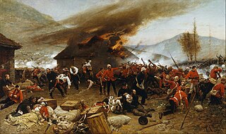
." Talana Hill is a flat-topped hill and was the scene of the famous Battle of Talana Hill on 20 October 1899, between the Boers and the British. [1]

Battle of Talana Hill battle

The Battle of Talana Hill, also known as the Battle of Glencoe, was the first major clash of the Second Boer War. A frontal attack by British infantry supported by artillery drove Boers from a hilltop position, but the British suffered heavy casualties in the process, including their commanding general Sir William Penn Symons.

Related Research Articles

Shaka leader of the Zulu Kingdom

Shaka kaSenzangakhona, also known as Shaka Zulu,Zulu pronunciation: [ˈʃaːɠa]), was one of the most influential monarchs of the Zulu Kingdom.

The Zulu are a Bantu ethnic group of Southern Africa and the largest ethnic group in South Africa, with an estimated 10–12 million people living mainly in the province of KwaZulu-Natal.

Battle of Rorkes Drift Battle in the Anglo-Zulu War, specifically the defence of the mission station of Rorkes Drift

The Battle of Rorke's Drift, also known as the Defence of Rorke's Drift, was an engagement in the Anglo-Zulu War. The successful defence of the mission station of Rorke's Drift, under the command of Lieutenants John Chard of the Royal Engineers and Gonville Bromhead, followed Britain's defeat at the Battle of Isandlwana on 22 January 1879 and continued into the following day.

KwaZulu-Natal Province of South Africa

KwaZulu-Natal is a province of South Africa that was created in 1994 when the Zulu bantustan of KwaZulu and Natal Province were merged. It is located in the southeast of the country, enjoying a long shoreline beside the Indian Ocean and sharing borders with three other provinces and the countries of Mozambique, Eswatini and Lesotho. Its capital is Pietermaritzburg and its largest city is Durban. It is the 2nd most populous province in South Africa, with slightly fewer residents than Gauteng.

Tugela River river in South Africa

The Tugela River is the largest river in KwaZulu-Natal Province, South Africa. It is one of the most important rivers of the country.

Kraal homestead

Kraal is an Afrikaans and Dutch word for an enclosure for cattle or other livestock, located within an African settlement or village surrounded by a fence of thorn-bush branches, a palisade, mud wall, or other fencing, roughly circular in form. It is similar to a boma in eastern or central Africa.

Port Edward, KwaZulu-Natal Place in KwaZulu-Natal, South Africa

Port Edward is a small resort town situated on the south coast of KwaZulu-Natal in South Africa, right on the Eastern Cape Province border.

Ixopo Place in KwaZulu-Natal, South Africa

Ixopo is a town situated on a tributary of the Mkhomazi River along the R56 highway in the midlands of KwaZulu-Natal, South Africa and forms part of an important sugar farming, and forestry area.

Kranskop Place in KwaZulu-Natal, South Africa

Kranskop is a small town that is situated on the edge of the Tugela River valley in KwaZulu-Natal, South Africa. It was founded in 1894 as Hopetown but the following confusion with another town of the same name in the Great Karoo, Northern Cape, the name was changed. Kranskop was chosen and is named after two cliff faces that rise 1,175 metres above the Tugela Valley near the town. The name is an Afrikaans word meaning "cliff head."

Sardine run Annual fish migration off the shores of South Africa

The sardine run of southern Africa occurs from May through July when billions of sardines – or more specifically the Southern African pilchard Sardinops sagax – spawn in the cool waters of the Agulhas Bank and move northward along the east coast of South Africa. Their sheer numbers create a feeding frenzy along the coastline. The run, containing millions of individual sardines, occurs when a current of cold water heads north from the Agulhas Bank up to Mozambique where it then leaves the coastline and goes further east into the Indian Ocean.

The Battle of Italeni was a battle that took place at 28°29′6″S31°16′27″E in what is now KwaZulu Natal province, South Africa, between the Voortrekkers and the Zulus during the period of the Great Trek.

Scott Glacier (Transantarctic Mountains)

The Scott Glacier is a major glacier, 120 miles (190 km) long, that drains the East Antarctic Ice Sheet through the Queen Maud Mountains to the Ross Ice Shelf. The Scott Glacier is one of a series of major glaciers flowing across the Transantarctic Mountains, with the Amundsen Glacier to the west and the Leverett and Reedy glaciers to the east.

Zulu Kingdom Former monarchy in Southern Africa

The Kingdom of Zulu, sometimes referred to as the Zulu Empire or the Kingdom of Zululand, was a monarchy in Southern Africa that extended along the coast of the Indian Ocean from the Tugela River in the south to Pongola River in the north.

Impati Mountain mountain in South Africa

Impati Mountain is a mountain near the town of Dundee in the province of KwaZulu-Natal, South Africa. The name "Impati" is a Zulu word meaning "leader". As the name implies, the mountain stands out noticeably, compared to the surrounding hills due to its elevation. Its foothills were the scene of the Battle of Talana Hill during the Second Boer War.

Kampala Hill Place in Central Uganda, Uganda

Kampala Hill, commonly referred to as Old Kampala, is a hill in the center of Kampala, Uganda's capital and largest city.

Buffalo River (KwaZulu-Natal) tributary of the Thukela River in South Africa

The Buffalo River is the largest tributary of the Tugela River in South Africa. Its source is in Majuba Hill, "Hill of Doves" in Zulu language, located northeast of Volksrust, close to the Mpumalanga / KwaZulu-Natal border. It follows a southerly route into KwaZulu-Natal past Newcastle then turns southeast past Rorke's Drift, before joining the Tugela River at Ngubevu near Nkandla. During the nineteenth century it formed part of the boundary between the Colony of Natal and Zululand.

Impendle Place in KwaZulu-Natal, South Africa

Impendle is a town in Umgungundlovu District Municipality in the KwaZulu-Natal province of South Africa.

Nquthu Place in KwaZulu-Natal, South Africa

Nquthu is a town in Umzinyathi District Municipality in the KwaZulu-Natal province of South Africa.

References

  1. Raper, Peter E. (1987). Dictionary of Southern African Place Names. Internet Archive. p. 427. Retrieved 28 August 2013.