Vryheid (Zulu: eFilidi/iFilidi/Abaqulusi) is a coal mining and cattle ranching town in northern KwaZulu-Natal, South Africa. Vryheid is the Afrikaans word for "freedom", while its original name of Abaqulusi reflects the abaQulusi clan based in the local area.[3]
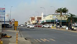
View of Church Street in Vryheid's Commercial District.
After Boer farmers, who lived in the Vryheid area, had helped King Dinuzulu defeat his rival chief Zibhebhu for succession of the Zulu throne, land that they occupied was given to them by cession from the Zulu king along the banks of the Mfolozi River. On August 5, 1884 the Boers formed the Nieuwe Republiek (New Republic) with Vryheid as its capital and its sovereignty was recognized by Germany and Portugal colonizers. It was later incorporated into the South African Republic, but at the end of the Second Boer War the town and its surrounding area was absorbed into the Natal colony by the British. Vryheid is located along the Transnet Coalline.
Other schools are Hoërskool Vryheid, which uses both Afrikaans and English as the medium of instruction and Hoërskool Pionier which uses Afrikaans as medium of instruction.
Sport
Kilian Academy, a martial arts academy instructing in the arts of Brazilian jiu-jitsu and Kickboxing, is situated in Vryheid.
Vryheid Wrestling Academy is one of the top wrestling clubs in the province of Kwa-Zulu Natal.
Hanami Gi-Challenge
The Hanami Gi-Challenge (commonly known as The Challenge) is a Brazilian Jiu-Jitsu (BJJ) tournament in Africa. The Hanami Gi-Challenges are hosted annually by the Hanami Martial Arts, with the first Challenge hosted in 2014 at the Indoor Speedball Club Vryheid in South Africa. In 2015, it will be held once again in Vryheid, South Africa.
Religion
The Inkamana Abbey, a Roman Catholic Benedictine abbey, is located in the town.
Heritage sites
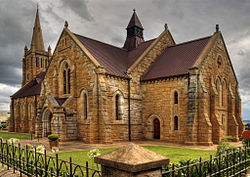
The Dutch Reform Church in Vryheid, better known as Die Moeder Gemeente (Afrikaans for the Mother Congregation), has been added to the list of 12 Gorgeous Churches and Cathedrals in Africa, by AFK Insider.[5]
Water shortages
The town experienced water shortages from 2016 to 2017 due to neglect of infrastructure. Pumps and pipelines were allowed to fall into a state of disrepair, forcing many town's residents to collect water from 15 communal water tanks provided by the municipality.[6] In its aftermath the Bhekuzulu clinic received 550 cases of diarrhea a month. Other residents invested at great personal cost in boreholes, water tanks, pumps, filters and power generators. Three sewage treatment plants also stopped functioning, polluting the Besterspruit and Klipfontein Dam.[6] Another outbreak of diarrhea occurred in 2019, with 535 people admitted to either Bhekuzulu or Mason Clinics.[7]
Notable residents
Louis Botha (27 September 1862 – 27 August 1919), Boer War general and first Prime Minister of the Union of South Africa, who represented the district of Vryheid whilst in parliament.
Danny Myburgh (born 1965), Springbok amateur boxing champion 1985 to 1988 and Vryheid Sportman of the year 1986 and 1987. Professional South African Lightweight Champion 1993 to 1995. World Lightweight Intercontinental contender 1994 and 1995.
Rolf Stumpf (1945–2020), statistician and Vice Rector.[9]
This page is based on this Wikipedia article Text is available under the CC BY-SA 4.0 license; additional terms may apply. Images, videos and audio are available under their respective licenses.