Ingwavuma is a town in the Umkhanyakude District Municipality of KwaZulu-Natal Province, South Africa. It is unclear where the name of the town came from; one theory is that it was named after the Ngwavuma River while another is that there was a leader called Vuma, the name then meaning "Vuma's place" in Zulu. Trees found on the river bank are also named Ngwavuma but it is unclear which entity was named after which. It is over 700 metres above sea level in the Lebombo Mountains and boasts several highly scenic spots. The town is three kilometres from the country's border with Eswatini and overlooks the plains of Maputaland to the East. It falls within the Mngomezulu Tribal Authority.
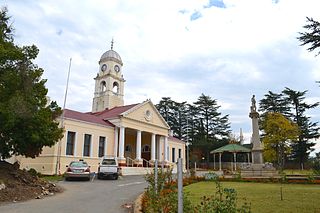
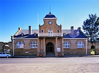
Kokstad is a town in the Harry Gwala District Municipality of KwaZulu-Natal Province, South Africa. Kokstad is named after the Griqua chief Adam Kok III who settled here in 1863. Kokstad is the capital town of the East Griqualand region, as it is also the biggest town in this region. It was built around Mount Currie, a local mountain range, by the city's founder Adam Kok III, for whom the town is named. Stad is the Dutch and Afrikaans word for "city". Kokstad has a population of about 50,000 people, making it the most populous town in East Griqualand, with most of its population being Xhosa people.
KwaDukuza is a town in KwaZulu-Natal, South Africa. In 2006, its official name was changed from Stanger to KwaDukuza, but the Zulu people in the area called it "Dukuza" well before then, and many South Africans still use the name "Stanger". "Stanger" has also been used on new road signs in the area.

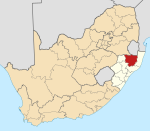
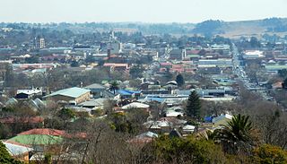
Barberton is a town in the Mpumalanga province of South Africa, which has its origin in the 1880s gold rush in the region. It is situated in the De Kaap Valley and is fringed by the Makhonjwa Mountains. It is 43 kilometres (27 mi) south of Mbombela and 360 kilometres (220 mi) east of Johannesburg.

Orange Farm ("Farma") is a township located approximately 45 km (28 mi) from Johannesburg, Gauteng Province, South Africa. It is the southernmost township of the City of Johannesburg Metropolitan Municipality. Its name, a misnomer given that oranges are grown in orchards instead of farms, has Dutch origins. It is one of the youngest townships in South Africa, with the original inhabitants, laid-off farm workers, taking up residency in 1988. Support for the population came slowly mostly from people who were tenants at the larger township of Soweto.
Utrecht is a town in the foothills of the Balele Mountains, in the northwestern corner of KwaZulu-Natal, South Africa. Newcastle, Kwazulu-Natal's third-largest urban centre, is 50 km from Utrecht. Utrecht has a population of approximately 32,000.
Pongola is a town on the left (north) bank of the Phongolo River, in a fertile valley on the N2, near the Lubombo Mountains, in the valleys of Zululand, easily accessible to the Swaziland border posts. It was part of the Transvaal panhandle between the Phongolo (Natal) and Swaziland until 1994, when it was transferred to KwaZulu-Natal.
Bethlehem is a large town in the eastern Free State province of South Africa that is situated on the Liebenbergs river along a fertile valley just north of the Rooiberg Mountains on the N5 road. It is the fastest growing town in the Free state province, with its target of being the Fourth largest city after Kroonstad in balance.

Rosendal is a small farming town and arts colony 49 km north of Ficksburg in the Free State province of South Africa which was founded in 1908. It has become a popular tourist destination, known for spectacular scenery, including the surrounding mountains, and is home to a community of artists and small business owners. The town has a number of attractive buildings and early-20th-century homes. There are several art galleries and several small cafes cum restaurants as well as a heritage district of restored buildings in the former downtown. Until recently live theatre was hosted here by well known Afrikaans language actor, Chris Van Niekerk.
Pinetown is a town that is part of the eThekwini Metropolitan Municipality, inland from Durban in KwaZulu-Natal, South Africa. Pinetown is situated 16 km west of Durban at an elevation of 1,000 to 1,300 feet.
Inanda is a township in KwaZulu-Natal, South Africa that is situated 30 km north-west of the Durban CBD; it forms part of eThekwini, the Greater Durban Metropolitan Municipality. Populated primarily by Zulu-speaking Black Africans, Inanda Township is the home of John Langalibalele Dube, first president of the African National Congress (ANC), as a residence/base of operations of Mahatma Gandhi, and as birthplace of the syncretic Nazareth Baptist Church
The people who reside in Molepolole are the Bakwena, who are one of the eight major tribes in Botswana. The Bakwena Kgosi (Chief), Sebele I was among the three chiefs who went to England to seek protection from the British in the colonial era. Molepolole serves as the capital of the Bakwena. It was named after the Molepolole river.

KwaBhaca, formerly Mount Frere, is a town located in the Eastern Cape province, previously known as the Transkei region, of South Africa. Its name in Xhosa is kwaBhaca, or "place of the Bhaca people", who settled here early on.

Woodstock is a suburb of Cape Town, South Africa, between the docks of Table Bay and the lower slopes of Devil's Peak, about 1 kilometre (0.6 mi) east of the city centre of Cape Town. Woodstock is served by Woodstock and Esplanade railway stations, and has the postal code 7925 for street addresses and 7915 for post office box deliveries.

Emmarentia is a suburb of Johannesburg, South Africa.

Beerwah also pronounced as Beeru is a subdistrict and one of the oldest town of Jammu and Kashmir and a municipal committee in Budgam district in the Indian administered union territory of Jammu and Kashmir. It is also one of the oldest tehsil of Jammu and Kashmir with one of the largest towns in Budgam district. Beerwah tehsil is known as the headquarter tehsil of all the tehsils of Jammu and Kashmir. Beerwah is 36 km away from the summer capital Srinagar via Magam, 33 km via Budgam & 27 km via Soibugh. Beerwah subdistrict has 4 tehsils namely Beerwah, Magam, Narbal, and Khag.

AbaQulusi Local Municipality is a local municipality in Zululand in the KwaZulu-Natal province of South Africa. It is named after the AbaQulusi, a Zulu clan whose descendants live in the vicinities of Vryheid, Utrecht, eDumbe and eNgoje. They hailed from different origins but were unified by their allegiance to local Zulu royal homesteads. Historically they were not drafted into ordinary "amabutho" regiments but rather into a royal section, and no "umnumzane" chief presented them in the Zulu king's council.
Mtwalume is a settlement in Ugu District Municipality in the KwaZulu-Natal province of South Africa.

Hoërskool Voortrekker is a public Afrikaans medium co-educational high school situated in the municipality of Boksburg in the city of Ekurhuleni in the Gauteng province of South Africa. The academic school was established in 1920.

Stora Blåsjön is a hamlet in Frostviken, Strömsund Municipality, Jämtland, Sweden. The area is known for its wilderness and skiing opportunities. Vildmarksvägen, a 360 kilometres (220 mi) wilderness road, bypasses the hamlet. Stora Blåsjön has a moose farm and a school museum.