
Rayagada district is a district in southern Odisha, a state in India, which became a separate district in October 1992. Its population consists mainly of tribes, primarily the Khonds and the Soras. In addition to Odia, Kui and Sora are spoken by the district's indigenous population. It was founded by Maharajah Biswanatha Deba Gajapati of the Surjyabansha dynasty of Jeypore.

Ganjam district is a district in the Indian state of Odisha. Ganjam's total area is 8,206 km² (3,168 mi²). The district headquarters is Chhatrapur. Ganjam is divided into three sub-divisions: Chhatrapur, Berhampur, and Bhanjanagar. The Imperial Gazetteer of India 1908 lists Ganjam, along with the Thanjavur and South Canara districts, as the three districts of the Madras Presidency where Brahmins were most numerous. As of 2011, it is the most populous district of Odisha.

Gajapati district is a district of Odisha State in India. It was carved out of Ganjam District on 2 October, 1992. As of 2011 it is the third least populous district of Odisha, after Debagarh and Boudh. Gajapati district was named after Krushna Chandra Gajapati Narayan Deb, the King of the Paralakhemundi estate and the first Prime Minister of Orissa, who is remembered for his contribution to the formation of a separate state, and inclusion of his estate in Odisha. The district headquarters at Paralakhemundi, formerly a Zamindari, has been clustered within a radius of approximately 5 kilometers around the geometric centre of Paralakhemundi.

Subarnapur District, also called Sonepur District or Sonapur District, is an administrative district in Odisha state in eastern India. The town of Sonpur is the district headquarters. Sonepur is known as the Mandiramalini town of Odisha with more than hundred temples. The people of the Sonepur region are referred to as Sonepuria. From ancient times, Sonepur is considered as a holy city.

Jajpur is a district of Odisha state in eastern India. The Odisha Government carried out a re-organisation of districts of Odisha in 1993. The erstwhile Cuttack district was split into multiple districts with Jajpur being one of them. The district came into being on 1 April 1993.
Balasore District, also known as Baleswar District, is an administrative district of Odisha state, in eastern India. Balasore is one of the coastal districts of Odisha and lies on the northernmost part of the state.

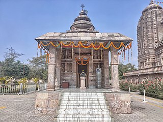
Paralakhemundi shortly known as Parala is district Headquarter of Gajapati district and one of the oldest Municipality established in 1885, in the Indian state of Odisha. Majority of the people in the town speak Odia. The city and the District share its boundaries with Andhra Pradesh. The adjacent town of Pathpatnam is separated by the River Mahendra Tanaya.In later medieval period it became capital of Paralakhemundi Estate of Eastern Ganga dynasty kings of Khemundi Branch. The town is well known for being an ancient cultural center of Odisha and birthplace of noted personalities including poet Gopalakrusna Pattanayaka, statesman Krushna Chandra Gajapati Narayan Deo, lexicographer Gopinatha Nanda Sharma and historian Satyanarayana Rajguru. This town is also known for its century old temples, monasteries, palaces and heritage buildings.
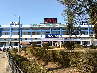
Rayagada is a municipality in Rayagada district in the Indian state of Odisha. It is the administrative headquarters of Rayagada district.
Barpali is a small town and a block (Tehsil) within the Bargarh district in the state of Odisha, India. Barpali is largely famous for renowned Odia Poet Swabhaba Kabi Gangadhar Meher who was born here. However, there are several other cultural notations which have made Barpali famous nationally and internationally, like: the indigenous sambalpuri saree weaving art and the earthen pottery handicrafts (Terracotta) etc, creations from the native inhabitants of Barpali. Among others, the name Barpali also draws attention towards the past studies, wide usage and then outward expansion of preliminary versions of sanitary toilets started by foreigners here, known as 'Barpali Toilets' nearly 40 years ago.
Bissam Cuttack is a town and Notified Area Council in the Rayagada district of Odisha, India.

Surada is a town and a Notified Area Council in Ganjam district in the Indian state of Odisha.
Badagam is a small village in the Rayagada Block and Parlakhemundi municipality in Gajapati district in the Indian state of Odisha. The major languages spoken in this place are Kui and Oriya.
G. Udayagiri is a Vidhan Sabha constituency of Kandhamal district, Odisha.

Mohana is a Vidhan Sabha constituency of Gajapati district, Odisha, India.
Badagada is a census town and former Zamindari estate in the Surada Block of Ganjam district, Odisha, India.

Durgi is a census village & Panchayat Headquarter of Bissam Cuttack Block in Rayagada district of Odisha, India. There are total 439 families residing in this village. The wards/ villages comes under Durgi Panchayat are:- Durgi, Bhaleri, Kundanpadar, Rengabai, Barangpadar, Thambalpadhu, Budhanagar, Kachapai, Kalipadar, Kurankul, Tentili Kalipadar, Mulipada, Dharamguda, Balipadar, Haduguda, Huruguda, Khariguda and IAY Colony.

R. Udaygiri is a village as well as tehsil and a community development block in the Gajapati District of Odisha, India. It is located 60 km from Paralakhemundi.
Aul is a town and the headquarters of Aul CD Block and Aul Tehsil in Kendrapara district in the Indian state of Odisha. It is 17 km from Chandabali. Aul is surrounded by the river Kharasrota and Brahmani on north and south respectively. To its east is Bhitarkanika National Park.

Mohana is Hill Valley town and community development block in the Gajapati district of Odisha state in India. The town comes under the administrative control of Mohana Police station.
Rayagada is a village and Community Development Block in the Gajapati District of Odisha state in India. The Block had a population of 99,568 in 2020 census. Mohana is its Vidhan Sabha constituency. This constituency includes Mohana block, R.Udayagiri block, Nuagada block and Rayagada block.


