Nuggety Gully Water Race and Chinese Camp

Last updated

Nuggety Gully Water Race and Chinese Camp
Nuggety Gully stone pitching (2014).jpg
Stone retaining walls at Nuggety Gully, 2014 (mobile phone in lower left for scale)
Location Mareeba Mining District, Lakeland, Shire of Cook, Queensland, Australia
Coordinates 15°58′39″S144°55′58″E / 15.9776°S 144.9328°E / -15.9776; 144.9328 Coordinates: 15°58′39″S144°55′58″E / 15.9776°S 144.9328°E / -15.9776; 144.9328
Design period 1870s - 1890s (late 19th century)
Builtc.1878 - c.1886
Official name: Nuggety Gully Water Race and Chinese Camp, Greasy Bill Creek water race, Prospect Creek Stone Walls, Star of Normanby Mine
Type state heritage (built, archaeological)
Designated 21 October 1992
Reference no. 600426
Significant periodc.1878-c.1886 (fabric)
Significant components terracing, shaft, water race, fireplace, mine - open cut, wall/s - retaining
Australia Queensland location map.svg
Red pog.svg
Location of Nuggety Gully Water Race and Chinese Camp in Queensland
Australia location map.svg
Red pog.svg
Nuggety Gully Water Race and Chinese Camp (Australia)

Nuggety Gully Water Race and Chinese Camp is a heritage-listed mining camp at Mareeba Mining District, Lakeland, Shire of Cook, Queensland, Australia. It was built from c.1878 to c.1886. It is also known as Greasy Bill Creek water race, Prospect Creek Stone Walls, and Star of Normanby Mine. It was added to the Queensland Heritage Register on 21 October 1992. [1]

Lakeland, Queensland Town in Queensland, Australia

Lakeland is a town and locality in the Shire of Cook, Queensland, Australia. In the 2011 census, Lakeland had a population of 227 people.

Shire of Cook Local government area in Queensland, Australia

The Shire of Cook is a local government area in Far North Queensland, Australia. The Shire covers most of the eastern and central parts of Cape York Peninsula, the most northerly section of the Australian mainland.

Queensland North-east state of Australia

Queensland is the second-largest and third-most populous state in the Commonwealth of Australia. Situated in the north-east of the country, it is bordered by the Northern Territory, South Australia and New South Wales to the west, south-west and south respectively. To the east, Queensland is bordered by the Coral Sea and Pacific Ocean. To its north is the Torres Strait, with Papua New Guinea located less than 200 km across it from the mainland. The state is the world's sixth-largest sub-national entity, with an area of 1,852,642 square kilometres (715,309 sq mi).

Contents

History

Gold was first discovered "officially" in the West Normanby River area, southwest of Cooktown, in November 1874. The first official figures estimate that by the end of January 1875, over 600 men were on the field, many from Maytown. At this point no Chinese appear to have been allowed (by Mining Warden Phillip Sellheim) to enter the diggings. However, by February 1878, at least 200 Chinese were reported to be working the alluvials. [1]

Normanby River river in northern Queensland, Australia

The Normanby River, comprising the East Normanby River, the West Normanby River, the East Normanby River North Branch, the East Normanby River South Branch and the Granite Normanby River, is a river system located in Far North Queensland, Australia.

Cooktown, Queensland Town in Queensland, Australia

Cooktown is a town and locality in the Shire of Cook, Queensland, Australia. Cooktown is located about 2,000 kilometres (1,200 mi) north of Brisbane and 328 kilometres (204 mi) north of Cairns, by road. Cooktown is about 857 kilometres (533 mi) south of Cape York by road. At the time of the 2016 census, Cooktown had a population of 2,631.

Maytown, Queensland ghost town in Queensland, Australia

Maytown was the main township on the Palmer River goldfields in Far North Queensland, Australia. It is now a ghost town within locality of Palmer in the Shire of Cook, having been active from c. 1874 to the 1920s. It was added to the Queensland Heritage Register on 1 June 2004.

In May 1886 Mining Warden Howard Saint George visited the diggings and reported 34 Europeans working the reefs and thirty to forty Chinese employed exclusively in alluvial workings and in gardening. There were three gardens principally devoted to maize, for which there was a ready sale at the reefs. [1]

In 1898 R. L. Jack, the Government Geologist, took a hurried look at the reefs long after most of the diggings had been abandoned. His map shows Chinese camps in the district but not at Nuggety Gully, between "Prospector's Gully" and the Star of Normanby reef. Therefore it is likely that the retaining walls and terraced camp site were constructed between 1878 (the heyday of early mining) and 1886. [1]

Description

Nuggety Gully is a deep ravine with a dry rocky watercourse which drains into Prospect (originally Prospector's) Creek The place includes a series of stone-pitched retaining walls that extend intermittently along Nuggety Gully for a distance of 600 metres (2,000 ft) north of the Prospect Creek junction from co-ordinates 15.58.53 S - 144.55.54 E to 15.58.37 S - 144.55.56 E. The retaining walls are constructed predominantly on the western side of the Gully. On some bends they are constructed on both sides of the creek, and in two or more tiers. The narrowest sections of the creek between retaining walls are about 2 metres (6 ft 7 in) in width. The walls vary from 1 to 2 metres (3 ft 3 in to 6 ft 7 in) in height. [1]

The Star of Normanby gold mine workings, comprising a small open cut and a caved shaft, extend across Nuggety Gully about 300 metres (980 ft) north of Prospect Creek and are in direct association with the retaining walls. [1]

A Chinese settlement site is located on Prospect Creek at its junction with Nuggety Gully. The site comprises nine small earth terraces, several containing stone edging and two containing fireplaces. The larger stone fireplace or oven has recently been partially reconstructed and sticks have been placed across the top. This structure has been wrongly described in a nomination to the Australian Heritage Commission for entry on the Register of the National Estate as "a fort in which Chinese miners hid from attacking Aborigines and fired on them". [1]

Heritage listing

Nuggety Gully Water Race and Chinese Camp was listed on the Queensland Heritage Register on 21 October 1992 having satisfied the following criteria. [1]

The place is important in demonstrating the evolution or pattern of Queensland's history.

The Nuggety Gully stone-pitched retaining walls and Chinese camp are significant in Queensland's history as the finest and most extensive surviving example of Chinese stonework. [1]

The place demonstrates rare, uncommon or endangered aspects of Queensland's cultural heritage.

The direct associations of stone retaining walls, Chinese camp sites and conventional mine workings is exceptional. [1]

The place has potential to yield information that will contribute to an understanding of Queensland's history.

Further archaeological and archival investigation could yield information on the extent of Chinese activities and involvement in the Star of Normanby mine area. [1]

The place is important in demonstrating the principal characteristics of a particular class of cultural places.

The quality of the stonework is significant and it has remained intact due to the broken nature of the country and the difficulties in achieving vehicle access, discouraging subsequent attempts at remining. [1]

Related Research Articles

Palmer River river in Queensland, Australia

The Palmer River is a river located in Far North Queensland, Australia. The area surrounding the river was the site of a gold rush in the late 19th century which started in 1873.

Norton Goldfield

Norton Goldfield is a heritage-listed former mine at Norton Road, near Nagoorin, Boyne Valley, Gladstone Region, Queensland, Australia. It was built from 1870s to 1941. It is also known as Milton Goldfield. It was added to the Queensland Heritage Register on 27 October 2006.

Wenlock Goldfield

Wenlock Goldfield is a heritage-listed mine in Archer River, Shire of Cook, Queensland, Australia. It was built from 1892 to 1950s. It is also known as Batavia Goldfield and Lower Camp (Wenlock). It was added to the Queensland Heritage Register on 3 March 2006.

Ebagoola Township and Battery

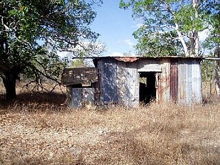
Ebagoola Township and Battery is a heritage-listed mining camp at Yarraden, Shire of Cook, Queensland, Australia. It was built from 1900 to 1913. It is also known as Ada Stewart Battery and Ebagoolah Township. It was added to the Queensland Heritage Register on 15 May 2006.

Alexandra Mine and Battery

Alexandra Mine and Battery is a heritage-listed mine at Palmerville Station, Maytown, Shire of Cook, Queensland, Australia. It was built from c. 1878 to 1898. It is also known as Alexandra PC.It was added to the Queensland Heritage Register on 21 October 1992.

Wild Irish Girl Mine and Battery

Wild Irish Girl Mine and Battery is a heritage-listed mine at Conglomerate Range, Maytown, Shire of Cook, Queensland, Australia. It was built from c. 1894 to 1980s. It is also known as Emily Battery. It was added to the Queensland Heritage Register on 21 October 1992.

Stonyville Township

Stonyville Township, Water Race and Cemetery is a heritage-listed mining camp at Mareeba Mining District, Palmer, Shire of Cook, Queensland, Australia. It was built from the 1870s to c. 1900. It is also known as Stony Creek Township, Stonyville Water Race, and Stonyville Cemetery. It was added to the Queensland Heritage Register on 21 October 1992.

Great Northern Mine

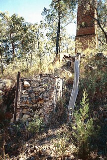
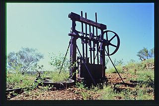
Great Northern Mine is a heritage-listed mine off Jacks Road, Herberton, Tablelands Region, Queensland, Australia. It was built from 1880 to 1940s. It was added to the Queensland Heritage Register on 21 October 1992.

Coolgarra Battery

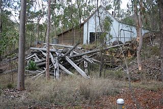
Coolgarra Battery is a heritage-listed stamper battery at Coolgarra Station, Silver Valley, Tablelands Region, Queensland, Australia. It was built from 1896 to 1901. It is also known as Coolgarra Old Furnace. It was added to the Queensland Heritage Register on 25 August 2000.

Anglo Saxon Mine

Anglo Saxon Mine is a heritage-listed mining camp at Groganville, Shire of Mareeba, Queensland, Australia. It was built from 1886 to 1897. It is also known as Groganville Township and Limestone Cemetery. It was added to the Queensland Heritage Register on 3 October 2003.

Fischerton Water Race

Fischerton Water Race is a heritage-listed aqueduct at Tate-Almaden Road, Crystalbrook, Shire of Mareeba, Queensland, Australia. It was designed by George Bell and built in 1894. It was added to the Queensland Heritage Register on 21 November 2003.

Mount Moran Battery

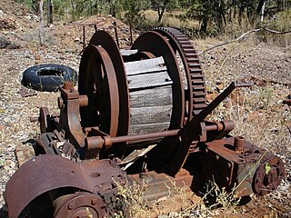
Mount Moran Battery is a heritage-listed former stamper battery at New Woolgar Road, Gilberton, Shire of Etheridge, Queensland, Australia. It was built from 1924 to c. 1936. It was added to the Queensland Heritage Register on 22 September 2000.

Ortona Mine and Battery

Ortona Mine and Battery is a heritage-listed mine at Forsayth-Agate Creek - Ortona (Iona) Station Road, Gilberton, Shire of Etheridge, Queensland, Australia. It was built from 1899 to 1908. It was added to the Queensland Heritage Register on 25 August 2000.

Aspasia Mine and Battery

Aspasia Mine and Battery is a heritage-listed mine and stamper battery at Gulf Developmental Road, Georgetown, Shire of Etheridge, Queensland, Australia. It was built from 1916 to 1952. It is also known as Mount Turner Battery. It was added to the Queensland Heritage Register on 13 April 2006.

Joseph Morris Mine mine in Australia

Joseph Morris Mine is a heritage-listed former mine at Georgetown Mining District, Gilberton, Shire of Etheridge, Queensland, Australia. It was built from 1903 to 1910. It was added to the Queensland Heritage Register on 5 April 2004.

Homeward Bound Battery and Dam dam in Australia

Homeward Bound Battery and Dam is a heritage-listed stamping mill and reservoir at Croydon, Shire of Croydon, Queensland, Australia. It was built in 1888 by Mr Schumacher. It was added to the Queensland Heritage Register on 21 October 1992.

Golden Gate Mining and Town Complex

Golden Gate Mining and Town Complex is a heritage-listed mining camp at Normanton Road, Croydon, Shire of Croydon, Queensland, Australia. It commenced in 1886. It is also known as Golden Gate Township, Croydon Consols Pump Shaft, Golden Gate No.10 North Mine, Golden Gate Cemetery, Croydon Consols Battery and Cyanide Plant, and Golden Gate Mine. It was added to the Queensland Heritage Register on 14 August 2009.

Bower Bird Battery

Bower Bird Battery is a heritage-listed former stamper battery in the Mount Isa Mining District, Mount Isa, City of Mount Isa, Queensland, Australia. It was built from c. 1895 to c. 1909. It was added to the Queensland Heritage Register on 13 December 2002.

Ravenswood Mining Landscape and Chinese Settlement Area

Ravenswood Mining Landscape and Chinese Settlement Area is a heritage-listed former mining town and archaeological site on the reserve bounded by School Street, Cemetery Road, Railway Street and Burdekin Falls Dam Road, Ravenswood, Charters Towers Region, Queensland, Australia. It was added to the Queensland Heritage Register on 14 October 2016.

References

  1. 1 2 3 4 5 6 7 8 9 10 11 12 "Nuggety Gully Water Race and Chinese Camp (entry 600426)". Queensland Heritage Register . Queensland Heritage Council. Retrieved 1 August 2014.

Attribution

CC-BY-icon-80x15.png This Wikipedia article was originally based on "The Queensland heritage register" published by the State of Queensland under CC-BY 3.0 AU licence (accessed on 7 July 2014, archived on 8 October 2014). The geo-coordinates were originally computed from the "Queensland heritage register boundaries" published by the State of Queensland under CC-BY 3.0 AU licence (accessed on 5 September 2014, archived on 15 October 2014).

Commons-logo.svg Media related to Nuggety Gully at Wikimedia Commons