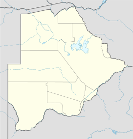
Botswana is a landlocked country located in Southern Africa, north of South Africa. Botswana occupies an area of 581,730 square kilometres (224,610 sq mi), of which 566,730 km2 (218,820 sq mi) are land. Botswana has land boundaries of combined length 4,347.15 kilometres (2,701.19 mi), of which the constituent boundaries are shared with Namibia, for 1,544 km (959 mi); South Africa 1,969 km (1,223 mi); Zimbabwe, 834 km (518 mi) and Zambia, 0.15 km (0.093 mi). Much of the population of Botswana is concentrated in the eastern part of the country.
The Kalahari Desert is a large semi-arid sandy savannah in Southern Africa extending for 900,000 square kilometres (350,000 sq mi), covering much of Botswana, and parts of Namibia and South Africa.
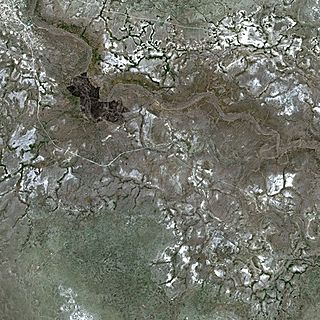
Lake Makgadikgadi ( məˈkɑːdiˈkɑːdi) was a paleolake that existed in what is now the Kalahari Desert in Botswana from 2,000,000 years BP to 10,000 years BP. It may have once covered an area of from 80,000 to 275,000 km2 and was 30 m deep. The Okavango, Upper Zambezi, and Cuando rivers once all emptied into the lake. Its remains are seen in the Makgadikgadi salt pans, one of the largest salt pans in the world.

The Boteti River is a natural watercourse in Botswana. It derives flow from the core Okavango Delta through the Thamalakane River in Maun.

Ghanzi is a district in western Botswana, bordering Namibia in the west and extending east into much of the interior of the country. The district's administrative centre is the town of Ghanzi. Most of the eastern half of Ghanzi makes up the Central Kalahari Game Reserve. The human population at the 2001 census was 43,370, less populous than that of any other district in Botswana. Ghanzi's area is 117,910 km².

The Makgadikgadi Pan, a salt pan situated in the middle of the dry savanna of north-eastern Botswana, is one of the largest salt flats in the world. The pan is all that remains of the formerly enormous Lake Makgadikgadi, which once covered an area larger than Switzerland, but dried up tens of thousands of years ago. Recent studies of human mitochondrial DNA suggest that modern Homo sapiens first began to evolve in this region some 200,000 years ago, when it was a vast, exceptionally fertile area of lakes, rivers, marshes, woodlands and grasslands especially favorable for habitation by evolving hominins and other mammals.

The Kalahari Basin, also known as the Kalahari Depression or the Okavango Basin, is an endorheic basin and large lowland area covering over 2.5 million km2 covering most of Botswana and Namibia, as well as parts of Angola, South Africa, Zambia, and Zimbabwe. The outstanding physical feature in the basin, and occupying the centre, is the large Kalahari Desert.

Nxai Pan National Park is a national park in north-eastern Botswana, consisting of Nxai Pan, which is one of the Makgadikgadi Pan salt flats. Nxai Pan National Park lies just north of the Maun-Nata main road and adjoins Makgadikgadi Pans National Park on its northern border. The pan itself is a fossil lakebed about 40 square km in size.
Kubu Island (Ga'nnyo) is a dry granite rock island located in the Makgadikgadi Pan area of Botswana. The island is located a few kilometers away from Orapa and Letlhakane mining towns and can be accessed through Mmatshumo in the Boteti district. The entire island is a national monument, and is considered a sacred site by the indigenous people of the area.

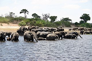
The wildlife of Botswana refers to the flora and fauna of Botswana. Botswana is around 90% covered in savanna, varying from shrub savanna in the southwest in the dry areas to tree savanna consisting of trees and grass in the wetter areas. Even under the hot conditions of the Kalahari Desert, many different species survive; in fact the country has more than 2500 species of plants and 650 species of trees. Vegetation and its wild fruits are also extremely important to rural populations living in the desert and are the principal source of food, fuel and medicine for many inhabitants.

Mopipi is a village in Central District of Botswana. It is located close to Makgadikgadi Pan.It lies at the latitude 21.2001° S, 24.8656° E. The population was 3,066 in 2001 census.This village was named after a tree called Mopipi,which is commonly found in the region.. This area has witnessed steady acidification and desertification since the Pleistocene, but perhaps most dramatically since the 19th century. In particular, the Boteti River used to flow year around in this area on its way to discharge to the Makgadikgadi Pans, but presently this flow is only in the rainy season.
The Ntwetwe Pan is a large salt pan within the Makgadikgadi region of Botswana. The Ntwetwe is one of three large pans within the Makgadikgadi, the other two being Nxai Pan and Sua Pan. Ntwetwe Pan is now a seasonal lake with filling occurring in the rainy season. Ntwetwe was first described to the European world by David Livingstone, pursuant to his explorations in this region. Significant archaeological recoveries have occurred within the Nwetwe Pan, including Stone Age tools from people who lived in this area, in an earlier time of prehistory when a large year round lake occupied the Nwetwe Pan area within the Makgadikgadi.
The Sua Pan or Sowa Pan is a large natural topographic depression within the Makgadikgadi region of Botswana. It is located near the village of Sowa, whose name means salt in the language of the San. The Sua salt pan is one of three large pans within the Makgadikgadi, the other two being Nxai Pan and Nwetwe Pan.
The Nata River or Manzamnyama River is a natural watercourse in Southern Africa. It is an ephemeral river flowing in Zimbabwe and Botswana. It has a length of 330 km from its source to mouth, 210 km in Zimbabwe and 120 km in Botswana. Its total catchment area is 24,585 km2. The river originates in Sandown, a small farming town located on the Zimbabwean central watershed 50 km south west of Bulawayo and ends in the Makgadikgadi Pans in Botswana. There is no outlet from the salt pans which can be considered as the “dead sea” of the south. The upper reaches of the river are located in a commercial farming area where good environmental and farming practices have resulted in the river experiencing very little siltation/sedimentation. Impressive sedimentation starts occurring about 65 km along the river course marking the beginning of a 90 km stretch in Zimbabwe where the river passes through communal farming areas. It is on this stretch where the sand-abstraction potential of the river is realised and communities rely on the sand river water for domestic, farming and livestock purposes. Within the country of Botswana the Nata River is a source of water to the ephemeral wetlands of the Makgadikgadi Pans, where a number of species of limited distribution thrive. Specifically the Nata River discharges to Sua Pan, draining parts of eastern Botswana and southwestern Zimbabwe.

Tsumkwe is a settlement in the Otjozondjupa Region of Namibia and the district capital of the Tsumkwe electoral constituency.

Kalahari Acacia-Baikiaea woodlands is an ecoregion located in Botswana, northern Namibia, South Africa and Zimbabwe.
Kavango–Zambezi Transfrontier Conservation Area was a conservation proposal for a region of Southern Africa where the international borders of five countries converge. It was to include a major part of the Upper Zambezi River and Okavango basins and Delta, the Caprivi Strip of Namibia, the southeastern part of Angola, southwestern Zambia, the northern wildlands of Botswana and western Zimbabwe. The centre of this area is at the confluence of the Zambezi and Chobe Rivers where the borders of Botswana, Namibia, Zambia and Zimbabwe meet. It would have incorporated Chobe National Park, Hwange National Park, and the Victoria Falls.

Gweta is a small village in Botswana. It lies about 205 kilometres (127 mi) away from Maun and about 100 kilometres (62 mi) from Nata.

The Nata Bird Sanctuary, the only protected reserve in Botswana in the northeastern periphery of Sowa Pan, is a community-managed project, with assistance from the Nata Conservation Committee and national and international organizations. Founded in 1988, it opened for operations in 1993; it encompasses an area of 230 square kilometres (89 sq mi), with the objective of conservation of wildlife. The community project is managed by a Trust titled the "Kalahari Conservation Society", which has members drawn from the four villages of Nata, Sepako, Maposa and Manxotae in the vicinity of the sanctuary.