
Burundi is located in East Africa, to the east of the Democratic Republic of the Congo, at the coordinates 3°30′S30°0′E.
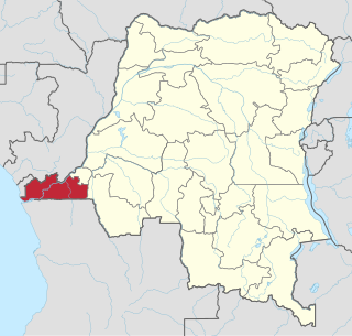
Kongo Central, formerly Bas-Congo is one of the 26 provinces of the Democratic Republic of the Congo. Its capital is Matadi.

Bandundu is one of eleven former provinces of the Democratic Republic of the Congo. It bordered the provinces of Kinshasa and Bas-Congo to the west, Équateur to the north, and Kasai-Occidental to the east. The provincial capital is also called Bandundu.

Équateur was a province in the northwest of the Belgian Congo and the successor Republic of the Congo, now known as Democratic Republic of the Congo. It had its origins in the Équateur District of the Congo Free State, the private property of King Leopold II of Belgium. It was upgraded to the status of a province in 1917. Between 1933 and 1947 it was named Coquilhatville. In 1962 it was divided into three smaller provinces, but there were recombined in 1966. Équateur was one of the eleven provinces of the Democratic Republic of the Congo until 2015, when it was split into the new, smaller Équateur province, as well as the Tshuapa, Mongala, Nord-Ubangi and Sud-Ubangi provinces.
Kasaï-Occidental was one of the eleven provinces of the Democratic Republic of the Congo between 1966 and 2015, when it was split into the Kasaï-Central and the Kasaï provinces.

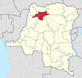
North Kivu is a province bordering Lake Kivu in the eastern Democratic Republic of the Congo. Its capital is Goma.
Orientale Province is one of the former provinces of the Democratic Republic of the Congo and its predecessors the Congo Free State and the Belgian Congo. It went through a series of boundary changes between 1898 and 2015, when it was divided into smaller units.
Ituri Province is one of the 21 new provinces of the Democratic Republic of the Congo created in the 2015 repartitioning. Ituri, Bas-Uele, Haut-Uele, and Tshopo provinces are the result of the dismemberment of the former Orientale province. Ituri was formed from the Ituri district whose town of Bunia was elevated to capital city of the new province.
Kananga, formerly known as Luluabourg or Luluaburg, is the capital city of the Kasai-Central Province in the Democratic Republic of the Congo and was the capital of the former Kasaï-Occidental Province. It is the fourth most populous urban area in the country, with an estimated population of 1,524,000 in 2021.

Équateur is one of the 21 new provinces of the Democratic Republic of the Congo created in the 2015 repartitioning. Équateur, Mongala, Nord-Ubangi, Sud-Ubangi, and Tshuapa provinces are the result of the dismemberment of the former Équateur province. The new province was formed from the Équateur district and the independently administered city of Mbandaka which retained its status as a provincial capital.
Mufulira is a town in the Copperbelt Province of Zambia. Mufulira means "Place of Abundance and Peace". The town developed around the Mufulira Copper Mine in the 1930s. The town also serves as the administrative capital of Mufulira District.

Kindu is a city in the Democratic Republic of Congo, the capital of Maniema province. It has a population of about 200,000 and is situated on the Lualaba River at an altitude of about 500 metres, and is about 400 km west of Bukavu.
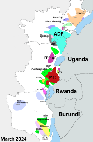
The Kivu conflict is an umbrella term for a series of protracted armed conflicts in the North Kivu and South Kivu provinces in the eastern Democratic Republic of the Congo which have occurred since the end of the Second Congo War. Including neighboring Ituri province, there are more than 120 different armed groups active in the eastern Democratic Republic of Congo. Currently, some of the most active rebel groups include the Allied Democratic Forces, the Cooperative for the Development of the Congo, the March 23 Movement, and many local Mai Mai militias. In addition to rebel groups and the governmental FARDC troops, a number of national and international organizations have intervened militarily in the conflict, including the United Nations force known as MONUSCO, and an East African Community regional force.

Angola is located on the western Atlantic Coast of Southern Africa between Namibia and the Republic of the Congo. It also is bordered by the Democratic Republic of the Congo and Zambia to the east. The country consists of a sparsely watered and somewhat sterile coastal plain extending inland for a distance varying from 50 to 160 km. Slightly inland and parallel to the coast is a belt of hills and mountains and behind those a large plateau. The total land size is 1,246,700 km2 (481,400 sq mi). It has an Exclusive Economic Zone of 518,433 km2 (200,168 sq mi).

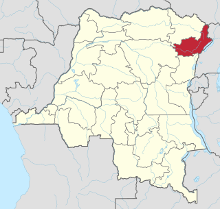
Haut-Uélé is one of the 21 new provinces of the Democratic Republic of the Congo created in the 2015 repartitioning. Haut-Uélé, Bas-Uélé, Ituri, and Tshopo provinces are the result of the dismemberment of the former Orientale province. Haut-Uélé was formed from the Haut-Uélé district whose town of Isiro was elevated to capital city of the new province.
Mongala is one of the 21 new provinces of the Democratic Republic of the Congo created in the 2015 repartitioning. Mongala, Équateur, Nord-Ubangi, Sud-Ubangi, and Tshuapa provinces are the result of the dismemberment of the former Équateur province. Mongala was formed from the Mongala District whose town of Lisala was elevated to capital city of the new province.

Tshuapa is one of the 21 new provinces of the Democratic Republic of the Congo created in the 2015 repartitioning. Tshuapa, Équateur, Mongala, Nord-Ubangi, and Sud-Ubangi provinces are the result of the dismemberment of the former Équateur province. Tshuapa was formed from the Tshuapa District whose town of Boende was elevated to capital city of the new province.

Kwango is a province of the Democratic Republic of the Congo. It's one of the 21 provinces created in the 2015 repartitioning. Kwango, Kwilu, and Mai-Ndombe provinces are the result of the dismemberment of the former Bandundu province. Kwango was formed from the Kwango district whose town of Kenge was elevated to capital city of the province.

The Allied Democratic Forces insurgency is an ongoing conflict waged by the Allied Democratic Forces in Uganda and the Democratic Republic of the Congo, against the governments of those two countries and the MONUSCO. The insurgency began in 1996, intensifying in 2013, resulting in hundreds of deaths. The ADF is known to currently control a number of hidden camps which are home to about 2,000 people; in these camps, the ADF operates as a proto-state with "an internal security service, a prison, health clinics, and an orphanage" as well as schools for boys and girls.

