In neuroscience, synaptic plasticity is the ability of synapses to strengthen or weaken over time, in response to increases or decreases in their activity. Since memories are postulated to be represented by vastly interconnected neural circuits in the brain, synaptic plasticity is one of the important neurochemical foundations of learning and memory.
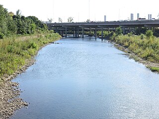
The Olentangy River is a 97-mile-long (156 km) tributary of the Scioto River in Ohio, United States.

Cranfield Point is the southernmost point of Northern Ireland. It is located at the mouth of Carlingford Lough in the townland of Cranfield, County Down.

Scupi is an archaeological site located between Zajčev Rid and the Vardar River, several kilometers from the center of Skopje in North Macedonia. A Roman military camp was founded here in the second century BC on the site of an older Dardanian settlement. It became later Colonia Flavia Aelia Scupi and many veteran legionnaires were settled there. A Roman town was founded in the time of Domitian and Scupi became the chief center for romanizing Dardania. It was abandoned in AD 518 after an earthquake destroyed the city.

Jacaranda FM, previously known as Jacaranda 94.2, is a South African radio station, broadcasting in English and Afrikaans, with a footprint that covers Gauteng, Limpopo, Mpumalanga and the North West Province and boasts a listening audience of 2 million people a week and a digital community of more than 1,1 million people a month. The station's format is mainstream with programming constructed around a playlist of hit music from the 1980s, 1990s and now.

Musgrave Park is a park in South Brisbane, Queensland, Australia. The park is bordered by Edmonstone, Russell, and Cordelia Streets, and Brisbane State High School, and has an area of 63,225 square metres (680,550 sq ft). The park is of cultural significance to Aboriginal Australians.

Broadbeach Waters is a suburb in the City of Gold Coast, Queensland, Australia. In the 2016 census, Broadbeach Waters had a population of 7,779 people.

Carrara is a suburb in the City of Gold Coast, Queensland, Australia. In the 2016 census, Carrara had a population of 12,060 people.
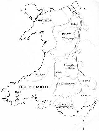
The Kingdom of Ceredigion was one of several Welsh kingdoms that emerged in 5th-century post-Roman Britain. Cardigan Bay to the west and the surrounding hilly geography made it difficult for foreign invaders to conquer. Its area corresponded roughly to that of the county of Ceredigion. Ceredigion transparently means "the people of Ceredig."

Wowan is a rural town and locality in the Shire of Banana, Queensland, Australia. In the 2016 census, the locality of Wowan had a population of 216 people.

Ravenswood is a rural town and locality in the Charters Towers Region, Queensland, Australia. In the 2016 census, the locality of Ravenswood had a population of 255 people.
The magnocellular red nucleus is located in the rostral midbrain and is involved in motor coordination. Together with the parvocellular red nucleus, the mRN makes up the red nucleus. Due to the role it plays in motor coordination, the magnocellular red nucleus may be implicated in the characteristic symptom of restless legs syndrome (RLS). The mRN receives most of its signals from the motor cortex and the cerebellum.

Rollingstone is a rural town and coastal locality in the City of Townsville, Queensland, Australia. In the 2016 census, the locality of Rollingstone had a population of 125 people.
The Emx gene family has two members: EMX1 and EMX2. The Emx genes are responsible for encoding these two transcription factors; the homeodomain is responsible for binding to target DNA sequences to regulate transcription.
Asyab Qashqa is a village in Pasakuh Rural District, Zavin District, Kalat County, Razavi Khorasan Province, Iran. At the 2006 census, its population was 23, in 12 families.

LY-215,840 is an ergoline derivative drug developed by Eli Lilly, which acts as a potent and selective antagonist at the serotonin 5-HT2 and 5-HT7 receptors. It has anti-hypertensive and muscle relaxant effects in animal studies.

Bill's is a British restaurant and bar chain, founded by Bill Collison in 2001 when he opened a small greengrocery in Lewes, East Sussex.

Euramo is a rural locality in the Cassowary Coast Region, Queensland, Australia. In the 2016 census, Euramo had a population of 147 people.
Gilla is a rural locality in the Toowoomba Region, Queensland, Australia. In the 2016 census Gilla had a population of 32 people.
Foveran Castle was a 12th- or 13th-century castle, about 4.5 miles (7.2 km) south -ast of Ellon, Aberdeenshire, Scotland, at Foveran, 1 mile (1.6 km) west of the mouth of River Ythan. It may also be known as Turing's Tower, or replace that castle. Foveran House Hotel lies 75 metres (246 ft) south -ast.