
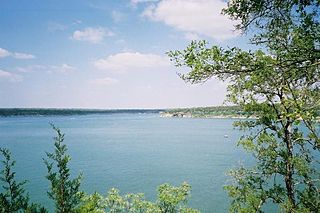
Lake Travis is a reservoir on the Colorado River in central Texas in the United States. It is named in honor of William B. Travis.
Lake Houston is a reservoir on the San Jacinto River, 15 miles (24 km) northeast of downtown Houston, Texas, United States. The reservoir is the primary municipal water supply for the city of Houston.

Somerville Lake is a U.S. Army Corps of Engineers reservoir on Yegua Creek in the Brazos River basin, 10 miles (16 km) northwest of Brenham, Texas, United States. The town of Somerville in Burleson County is adjacent to the reservoir. The lake extends into portions of Burleson County, Washington County, and Lee County. The dam lies in Washington County. The dam and lake are managed by the Fort Worth District of the U.S. Army Corps of Engineers. The reservoir was officially impounded in 1967, and serves to provide flood control and water for irrigation for the communities downstream. Somerville Lake is a popular recreational destination.
Lake Whitney is a flood control reservoir on the main stem of the Brazos River in Texas. It is located on River Mile Marker 442 and controls drainage for 17,656 square miles (45,730 km2) of Texas and parts of New Mexico. The reservoir encompasses a surface area of more than 23,500 acres and 225 miles (362 km) of shoreline. The area consists of rolling, tallgrass prairies; cedar trees; hardwood timber; and 100 ft (30 m) bluffs and rock points. Lake Whitney is also part of the Texas Lakes Trail Region of North Texas.
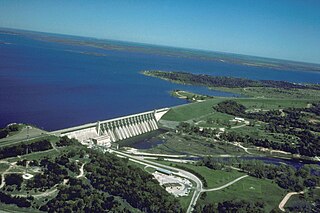
Lake Georgetown is a reservoir on the north fork of the San Gabriel River in central Texas in the United States. Lake Georgetown is a U.S. Army Corps of Engineers reservoir formed on the San Gabriel by the North San Gabriel Dam, which is located about three miles west of Georgetown, Texas. The dam, lake and all adjacent property are managed by the Fort Worth District of the Corps of Engineers. The dam was officially completed on October 5, 1979, and serves to provide flood control for the community of Georgetown. Lake Georgetown, a popular recreational destination, is also a source of drinking water for Georgetown and the nearby city of Round Rock.

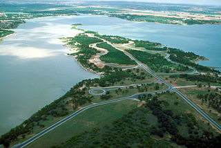
Canyon Lake is a reservoir on the Guadalupe River in the Texas Hill Country in the United States. Canyon Lake is a U.S. Army Corps of Engineers reservoir formed on the Guadalupe River in Comal County by Canyon Dam, which is located about sixteen miles northwest of New Braunfels. The dam, lake, and all adjacent property are managed by the U.S. Army Corps Of Engineers. Water rights, waste water treatment, and hydroelectric generating facilities are managed by the Guadalupe-Blanco River Authority. Construction of the dam began in 1958 and was completed in 1964. The reservoir serves to provide flood control and water supply for the communities downstream from the dam. The lake is also a popular recreational destination.

Choke Canyon Reservoir is a reservoir in South Texas, United States. The lake and the dam that creates it are owned by the United States Bureau of Reclamation and managed by the City of Corpus Christi.

Brady Creek Reservoir is a reservoir on Brady Creek in McCulloch County, Texas in the United States. The lake is about 3 miles west of downtown Brady, Texas. The dam and lake are managed by the City of Brady. The reservoir was officially impounded in 1963. The reservoir is also sometimes called Brady Reservoir or Brady Lake. The dam for Brady Creek Reservoir is 8,400 ft. long and 104 ft. high and has a storage capacity of 30,430 acre-Ft.

Lake Casa Blanca is a reservoir on the Chacon Creek, 5 miles (8 km) northeast of downtown Laredo, Texas, United States. The reservoir was formed in 1951 by the construction of a dam to provide recreational opportunities for the residents of Webb County. The current dam is the second built across the creek - a previous dam built in 1946 failed the following year during the initial attempted impounding of a reservoir. There are residential properties along the lake as well as a Texas state park. Surrounding the lake is a 525-acre (212 ha) park that was operated jointly by the City of Laredo and Webb County before it was leased by the state in 1990 and opened in March 1991 as the Lake Casa Blanca International State Park. Lake Casa Blanca is fed by the Chacon Creek and San Ygnacio Creek.

Lake Corpus Christi is a reservoir in coastal southern Texas. The lake was created by impoundment of the Nueces River by the Wesley E. Seale Dam opened in 1958. The lake and the dam that creates it are managed by the City of Corpus Christi. Lake Corpus Christi was originally known as Lake Lovenskiold. It is often referred to as Lake Mathis because of its location.

Stillhouse Hollow Lake is a U.S. Army Corps of Engineers reservoir on the Lampasas River in the Brazos River basin, 5 miles (8 km) southwest of Belton, Texas, United States. Stillhouse Hollow Dam and the reservoir are both managed by the Fort Worth District of the U.S. Army Corps of Engineers. The reservoir was officially impounded in 1968, and serves to provide flood control for the communities downstream. The lake also functions as a water supply for several of the surrounding communities. Stillhouse Hollow Lake is a popular recreational destination.

Belton Lake is a U.S. Army Corps of Engineers reservoir on the Leon River in the Brazos River basin, 5 miles (8 km) northwest of Belton, Texas, United States. The lake extends into both Bell County and Coryell County. Belton Dam and the lake are both managed by the Fort Worth District of the U.S. Army Corps of Engineers. The reservoir was officially impounded in 1954, and serves to provide flood control and drinking water for Belton, Temple, and the surrounding communities. Belton Lake is a popular recreational destination. In the fall of 2018 Lake Belton was host to the annual “Lonestar Throwdown” kayak fishing tournament. Teams from the North, South, Central, and West Texas regions battled it out for bragging rights and ultimately North Texas took home the coveted trophy.
Proctor Lake is a U.S. Army Corps of Engineers reservoir along the Leon River located in Comanche County in the U.S. state of Texas, around 3 miles (5 km) west of Proctor, Texas. Proctor Lake Dam and the reservoir are managed by the Fort Worth District of the U.S. Army Corps of Engineers. The reservoir was officially impounded in 1963, and serves to provide flood control and drinking water for the communities downstream. Proctor Lake is a popular recreational destination.

Lavon Lake is a freshwater reservoir located in southeast Collin County, Texas, on the East Fork of the Trinity River near Wylie, off State Highway 78. It is commonly called Lake Lavon for commercial and recreational purposes, but Lavon Lake is its official name according to the U.S. Army Corps of Engineers. It was originally called Lavon Reservoir.

Aquilla Lake is an artificial lake (reservoir) in Hill County, Texas, USA. The dam was constructed by the U.S. Army Corps of Engineers. The dam is part of the overall flood control project in the Brazos River basin. The lake is located approximately 23 miles (37 km) north of Waco, Texas, and directly north of the town of Aquilla.

E.V. Spence Reservoir is an artificial lake located west of the town of Robert Lee, Texas. The reservoir was impounded by the creation of Robert Lee Dam in 1969, with the support of the Upper Colorado River Authority, to provide a reliable water supply for Robert Lee and the surrounding communities in Coke County. The lake also serves as a recreational venue for fishing, boating, and swimming. Robert Lee Dam is managed by the Colorado River Municipal Water District.
Twin Buttes Reservoir is an artificial lake located about 6 mi (9.7 km) southwest of the city of San Angelo, Texas, and immediately upstream from Lake Nasworthy. Construction on Twin Buttes Dam to form the reservoir was completed in 1963. The dam is an unusual one – it dams the Middle and South Concho Rivers separately; a stabilization channel runs between the two sides of the lake. Water levels fell significantly during the 2010–13 Southern United States drought and remained low into 2014.

San Angelo State Park is a Texas state park in San Angelo, Texas in the United States. It encompasses 7,677 acres (3,107 ha) leased by Texas Parks and Wildlife Department from the United States Army Corps of Engineers. It opened in 1995 and is located on the shores of the O.C. Fisher Reservoir.

Lake Alan Henry is a reservoir situated in the upper Brazos River Basin in the United States. Created by the construction of the John T. Montford Dam in 1993, it is operated and used as a future tertiary water supply by the city of Lubbock, Texas and serves as a recreational spot for the region of West Texas. The surface area of the lake is 2,880 acres (1,170 ha) with a mean depth of 40 ft (12 m). Lake Alan Henry is located 4 mi (6.4 km) east of Justiceburg, Texas, and 45 mi (72 km) south of Lubbock.

