Related Research Articles

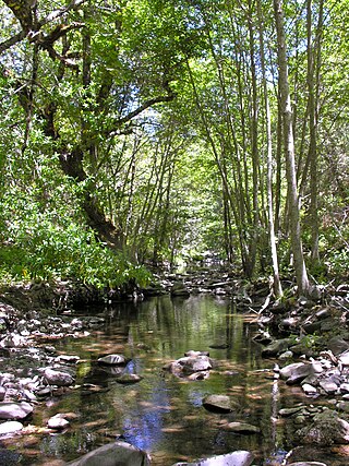
Arroyo Hondo is a northwestward-flowing 13-mile-long (20.9 km) river in Santa Clara County, California, United States, that lies east of Milpitas. The area is privately owned by the San Francisco Water Department and is closed to public access because of its usage as drinking water. Bounded to the east by Oak Ridge and to the west by Poverty Ridge, Arroyo Hondo empties into the Calaveras Reservoir where it joins Calaveras Creek. It is formed by the confluence of Smith Creek and Isabel Creek which drain the west and east slopes of Mount Hamilton, respectively.

The Great Mall of the Bay Area is a large indoor outlet shopping mall in Milpitas, California built by Ford Motor Land Development and Petrie Dierman Kughn in 1994. It was acquired by Mills Corporation in 2003, and by the Simon Property Group in April 2007. The mall contains approximately 1.4 million square feet of gross leaseable area. The anchor stores are Century Theatres, Kohl's, Dick's Sporting Goods, Home Interiors Furniture, Q, Saks Off 5th, Marshalls, Burlington, Dave & Buster's and the Legoland Discovery Center.

Black Mountain, also known as Mount Day, is a mountain in the Diablo Range of eastern Santa Clara County, California, east of Poverty Ridge and Arroyo Hondo, and about 10 miles (16 km) from Milpitas.

The Diablo Range is a mountain range in the California Coast Ranges subdivision of the Pacific Coast Ranges in northern California, United States. It stretches from the eastern San Francisco Bay Area at its northern end to the Salinas Valley area at its southern end.

Berryessa Creek is a seasonal creek in northeastern San Jose and Milpitas. Its main source is located in the Los Buellis Hills slightly west of Felter Road. Berryessa Creek has many tributaries, including Piedmont Creek and Calera Creek. In the summer, Berryessa Creek is mostly dry except in Milpitas, where much of its water comes from urban runoff and tributaries. In winter, however, the water can rise high and pose a hazard for surrounding residences. The creek was named after a member of the prominent Basque–Spanish Berreyesa family: Nicolas Berreyesa, a Californio settler granted the Rancho Milpitas in 1834.
Poverty Ridge is a ridge in unincorporated Santa Clara County, California, east of Milpitas. Calaveras Valley lies to its west, while its east side slopes down to meet Arroyo Hondo. Creeks that originate on Poverty Ridge include Calaveras and Penitencia Creeks.
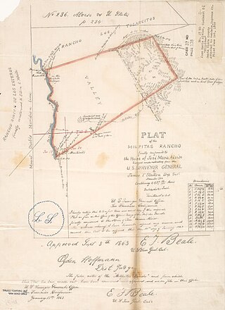
Rancho Milpitas was a 4,458-acre (18.04 km2) Mexican land grant in Santa Clara County, California. The name comes from the Nahuatl "milpan", a term meaning "in the field". Therefore, Milpitas could be translated as "little fields". The grant included what is now the city of Milpitas.
Smith Creek is a 14-mile-long (23 km) perennial stream which flows along the western flank of Mount Hamilton in Santa Clara County. The creek begins near Bollinger Ridge, about 7.7 km SxSW of Mount Hamilton.

Eaton Canyon is a major canyon beginning at the Eaton Saddle near Mount Markham and San Gabriel Peak in the San Gabriel Mountains in the Angeles National Forest, United States. Its drainage flows into the Rio Hondo river and then into the Los Angeles River. It is named after Judge Benjamin S. Eaton, who lived in the Fair Oaks Ranch House in 1865 not far from Eaton Creek.

La Honda Creek is a 7 miles (11 km) long stream on the Pacific slope of the Santa Cruz Mountains and is a tributary of San Gregorio Creek. From its source near Bear Gulch Road and Skyline Boulevard (CA 35) in San Mateo County, California, La Honda Creek's water flow south to its confluence with Alpine Creek to form San Gregorio Creek in La Honda, and thence to the Pacific Ocean.
Rancho Milpitas was a 43,281-acre (175.15 km2) Mexican land grant in present-day Monterey County, California given in 1838 by governor Juan Alvarado to Ygnacio Pastor. The grant encompassed present day Jolon.
Amador Valley is a valley in eastern Alameda County, California and is the location of the cities of Dublin and Pleasanton. Part of Tri-Valley, the valley is bounded by the foothills of the Diablo Range on the north and south, Pleasanton Ridge to the west, and Livermore Valley to the east.
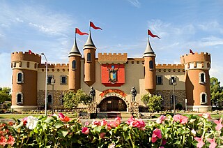
Golfland Entertainment Centers are a chain of family amusement centers, miniature golf courses, and water parks located in California and Arizona. The company was founded in 1953.
Rancho Arroyo del Rodeo was a 1,473-acre (5.96 km2) Mexican land grant in present-day Santa Cruz County, California, USA, given in 1834 by Governor José Figueroa to Francisco Rodríguez. The grant extended from the Pacific Ocean between Rodeo Creek Gulch on the west and Soquel Creek on the east, encompassing portions of several present-day communities: eastern Live Oak, western Soquel and western Capitola.
The Newby Island Landfill (NISL) is one of the largest active landfills on the shores of the San Francisco Bay. It is located in Santa Clara County, California in the United States. The site is located within the city limits of San Jose, California at the western terminus of Dixon Landing Road. The address is 1601 Dixon Landing Road, Milpitas. Although the address and public street access to the site are both in the City of Milpitas, the landfill property is entirely within the City of San Jose. Newby Island Landfill has a length of 5.07 km (3.15 mi). It is located West of the City of Milpitas near Dixon Landing Road and Interstate 880. It is the terminus for waste for all of San Jose (62%), Santa Clara (14%), Milpitas (10%), Cupertino (5%), Los Altos (2%) and other cities (7%). The 342-acre pile is currently permitted to operate until 2041 and may extend up to 245 feet. The landfill is an island surrounded by a levee which keeps its runoff from directly entering the bay, and the water that drains from it is treated in the landfill's own treatment plant. Electricity for the landfill is generated by burning the methane collected from the decomposition of the waste. Dried sewage sludge from the nearby San José–Santa Clara Regional Wastewater Facility is the material used as cover, mixed in with the trash, blending San Jose's waste streams. It is operated by Republic Services (Republic), which, along with Waste Management Incorporated, transports and disposes of most of the household trash in the United States.

Isabel Creek is a 18-mile-long (29 km) perennial stream which flows northwesterly along the eastern then northern flank of Mount Hamilton in Santa Clara County. It joins Smith Creek to form Arroyo Hondo north of Mt. Hamilton and is part of the southernmost Alameda Creek watershed.
La Vereda del Monte was a backcountry route through remote regions of the Diablo Range, one of the California Coast Ranges. La Vereda del Monte was the upper part of La Vereda Caballo,, used by mesteñeros from the early 1840s to drive Alta California horses to Sonora for sale.
Paradise Flat is a flat in the Diablo Range, within Henry W. Coe State Park in Stanislaus County, California. It lies at an elevation of 1,224 / 373 meters along north bank of the South Fork Orestimba Creek, just above the Rooster Comb.
Mustang Flat is a flat in the Diablo Range in Stanislaus County, California. It lies at an elevation of 1,329 feet south of the South Fork Orestimba Creek, north of Mustang Peak.
Red Hill is a summit on the eastern slope of the Diablo Range, in Merced County, California. Its highest elevation is 2,326 feet. The summit is part of a long ridge where its high point is between 37°07′35″N121°11′31″W and 37°07′27″N121°11′50″W. The Red Mountain Road, runs over this ridge between Fifield Road on the divide of the Diablo Range and McCabe Road on Romero Creek.
References
- ↑ Loomis, Patricia. Milpitas: A Century of Little Cornfields, 1852–1952. Milpitas Local History Studies, vol. 30.
- "Oak Ridge". Geographic Names Information System . United States Geological Survey, United States Department of the Interior. 19 January 1981. Retrieved 2009-11-15.
37°27.6′N121°43.3′W / 37.4600°N 121.7217°W
| | This Santa Clara County, California-related article is a stub. You can help Wikipedia by expanding it. |