Oakura

Last updated

Oakura
NZ-Taranaki plain map.png
Disc Plain red.svg
Oakura
Coordinates: 39°7′3″S173°57′16″E / 39.11750°S 173.95444°E / -39.11750; 173.95444
Country New Zealand
Region Taranaki
District New Plymouth District
Population (2013)
  Total 1,380

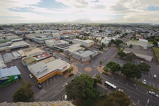
Oakura is a small township in New Plymouth District, Taranaki, in the western North Island of New Zealand. It is located on State Highway 45, 15 kilometres south-west of New Plymouth. Okato is 12 km further south-west. The Oakura River flows past the town and into the North Taranaki Bight. To the south is the Kaitake Range, part of Egmont National Park. [1] [2]

New Plymouth District Territorial authority in Taranaki, New Zealand

The New Plymouth District is one of the districts of New Zealand within Taranaki. It includes the city of New Plymouth and smaller towns such as Inglewood, Oakura and Waitara.

Taranaki Region of New Zealand in North Island

Taranaki is a region in the west of New Zealand's North Island, administered by the Taranaki Regional Council. It is named after its main geographical feature, the stratovolcano of Mount Taranaki.

North Island The northern of the two main islands of New Zealand

The North Island, also officially named Te Ika-a-Māui, is one of the two main islands of New Zealand, separated from the larger but much less populous South Island by Cook Strait. The island's area is 113,729 square kilometres (43,911 sq mi), making it the world's 14th-largest island. It has a population of 3,749,200.

Contents

The population of Oakura was 1,380 in the 2013 census, an increase of 21 from 2006. [3]

The 2013 New Zealand census was the thirty-third national census. "The National Census Day" used for the census was on Tuesday, 5 March 2013. The population of New Zealand was counted as 4,242,048, – an increase of 214,101 or 5.3% over the 2006 census.

The Oakura Messenger (TOM) is a monthly publication delivered to all letterboxes in the area. It began in October 2000. [4]

On 5 July 2007 the town was hit by a tornado, which damaged 60 houses. [5]

Oakura is well known for its beach—Oakura Beach. One of only three beaches along the west coast of New Zealand which is north facing, in 2007 it became one of the first Blue Flag accredited beaches in Oceania. Only two others—Fitzroy and East End beach in nearby New Plymouth—received the same award that year. As of 2010, Oakura Beach has retained its blue flag status. [6]

Blue Flag beach Certification for high quality beaches

The Blue Flag is a certification by the Foundation for Environmental Education (FEE) that a beach, marina, or sustainable boating tourism operator meets its stringent standards.

The Oakura River (and therefore Oakura township itself) was named after the female ancestor Akura-matapū of the Kurahaupō waka. Oakura-matapu was the original name of the river, and it literally means "Belonging to Akura-matapū". Akura was married to Okorotua. Ngāti Tairi hapū holds mana whenua in Oakura. Ngāti Tairi belongs to the larger descent group of Ngā Mahanga a Tairi. Ngāti Tairi and Ngā Māhanga a Tairi are a part of the tribe Taranaki. Ngāti Tairi retain their take ahi-kā (rights of ownership) through the marae Oakura Pā beside the southern side of the Oakura River. People have been living in the area of Oakura for hundreds of years.

When war broke out in 1860, Ngāti Tairi as part of Nga Mahanga and Taranaki joined in the offensives against the British. The nearby Tapuae ridge (north of Oakura) was a continual site of conflict. On 4 May 1863 a party of about 40 Māori warriors ambushed a small military party on a coastal road west of the town, killing nine of the 10 soldiers. The revenge attack on the military party, escorting a British defaulter to New Plymouth for trial, reignited hostilities in the Taranaki War. [7] [8]

Second Taranaki War

The Second Taranaki War is a term used by some historians for the period of hostilities between Māori and the New Zealand Government in the Taranaki district of New Zealand between 1863 and 1866. The term is avoided by some historians, who either describe the conflicts as merely a series of West Coast campaigns that took place between the Taranaki War (1860–1861) and Titokowaru's War (1868–69), or an extension of the First Taranaki War.

Amenities and Services

South Road (better known as Surf Highway 45) is Oakura's main street, and most local businesses and services are situated around here.

Features and attractions

Apart from its well-known beach, Oakura's main attraction is Butlers Reef – a bar and music venue that has showcased many well-known New Zealand and international acts, including Dave Dobbyn, Trinity Roots, Gin Wigmore, Katchafire, Supergroove and Jimmy Barnes.

Other places of interest include the township's three parks – Matekai, Corbett and the Shearer Reserve. Also, within five minutes drive south west is Lucy's Gully, a popular beauty spot in the Kaitake ranges that hit the national headlines in 2005 when the body of murdered German tourist Birgit Brauer was discovered there. [9]

Koru is a historic reserve situated 3 km south-east of Oakura township. Thought to be one of the first Māori settlements in Taranaki, Māori tradition recognises that it may have been built as early as 1000AD by Nga Mahanga a Tairi, a hapū of the Taranaki iwi. [10]

Ringcraft Moana is a manufacturing jewellery business with showroom, garden and a large pearl collection of abalone pearls. [11] The Wavehaven, on Surf Highway 45 just south of Oakura, offers accommodation and access to surfing beaches. [12]

Once a year Oakura's artists are opening up their studios to the public in a two weekend event. The Oakura Arts Trail can be found online [13]

Education

Oakura School is a coeducational full primary (years 1-8) school with a decile rating of 10 [14] and a roll of 321 students as of February 2018. [15] The school was founded in 1866. [16]

Oakura PlayCentre is a registered Early Childhood Facility that caters to children from ages 0 – 6 years. It is licensed for 3 mornings a week; Mondays, Wednesdays and Fridays. Playcentre philosophy is based on child-initiated play and recognises the parents as the first and best educators of their own children. Playcentre families receive a unique early childhood experience with opportunities for whānau/families to learn together.

Notable residents

Related Research Articles

Inglewood, New Zealand Place in Taranaki, New Zealand

Inglewood is a town in the Taranaki Region of New Zealand's North Island. The population was 3,090 in the 2006 census, an increase of 144 from 2001. In 2013 it had risen to 3,243.

Ngāti Whātua Māori iwi (tribe) in Aotearoa New Zealand

Ngāti Whātua is a Māori iwi (tribe) of the lower Northland Peninsula of New Zealand's North Island. It comprises a confederation of four hapū (subtribes) interconnected both by ancestry and by association over time: Te Uri-o-Hau, Te Roroa, Te Taoū, and Ngāti Whātua-o-Ōrākei. The four hapū can act together or separately as independent tribes.

Ngāti Porou Māori iwi (tribe) in Aotearoa New Zealand

Ngāti Porou is a Māori iwi traditionally located in the East Cape and Gisborne regions of the North Island of New Zealand. Ngāti Porou is affiliated with the 28th Maori Battalion and has the second-largest affiliation of any iwi in New Zealand, with 71,910 registered members in 2006. The traditional rohe or tribal area of Ngāti Porou extends from Pōtikirua and Lottin Point in the north to Te Toka-a-Taiau in the south.

Waitara, New Zealand Place in Taranaki, New Zealand

Waitara is a town in the northern part of the Taranaki region of the North Island of New Zealand. Waitara is located just off State Highway 3, 15 kilometres (9.3 mi) northeast of New Plymouth. Its population was 6312 in the 2013 census, an increase of 24 from 2006.

Opunake Minor urban area in Taranaki, New Zealand

Opunake is a small town on the southwest coast of Taranaki in New Zealand's North Island. It is located 45 kilometres southwest of New Plymouth. Rahotu is 16 km to the northwest. Manaia is 29 km to the southeast. State Highway 45 passes through the town.

Hawera Place in Taranaki, New Zealand

Hawera is the second-largest town in the Taranaki region of New Zealand's North Island, with a population of 12,150. It is near the coast of the South Taranaki Bight. The origins of the town lie in a government military base that was established in 1866, and the town of Hawera grew up around a blockhouse in the early 1870s.

Ngāi Te Rangi Māori iwi (tribe) in Aotearoa New Zealand

Ngāi Te Rangi or Ngāiterangi is a Māori iwi, based in Tauranga, New Zealand. Its rohe extends to Mayor Island / Tuhua and Bowentown in the north, to the Kaimai Range in the west, south of Te Puke and to Maketu in the east.

Waikato Tainui, Waikato or Tainui is a group of Māori people iwi based in Waikato Region, in the western central region of New Zealand's North Island. It is part of the larger Tainui confederation of Polynesian settlers who arrived to New Zealand on the Tainui waka. The tribe is named after the Waikato River, which plays a large part in its history and culture.

Okato Place in Taranaki, New Zealand

Okato is a small township in rural Taranaki, New Zealand. The population was 561 in the 2013 census, an increase of 30 from 2006. It is situated about 25 minutes drive around the coast from New Plymouth on State Highway 45. Oakura is 12 km to the north-east, and Warea is 9 km to the south-west. The place offers popular rocky surfing spots around coastal beaches.

Ngaere Place in Taranaki, New Zealand

Ngaere is a village situated on State Highway 3, 4 kilometres (2.5 mi) south of Stratford, New Zealand. The name "Ngaere" literally means "swamp" in English, and before settlement, the area was covered by a vast and ancient wetland.

Ngāti Pūkenga Māori iwi (tribe) in Aotearoa New Zealand

Ngāti Pūkenga is a Māori iwi centred in Tauranga in the Bay of Plenty region of New Zealand. Its rohe extends to Mayor Island / Tuhua and Waihi in the north, to the Kaimai Range in the west, south of Te Puke and to Maketu in the east, and it has tribal holdings in Whangarei, Hauraki and Maketu.

Mokoia Place in Taranaki, New Zealand

Mokoia is a small settlement in south Taranaki, in the western North Island of New Zealand. It is located on State Highway 3, 10 kilometres (6.2 mi) to the east of Hawera and about 17 km northwest of Patea.

Urenui Place in Taranaki, New Zealand

Urenui is a settlement in northern Taranaki, in the North Island of New Zealand. It is located on State Highway 3 close to the shore of the North Taranaki Bight, 13 kilometres east of Waitara and 6 km south-west of Mimi. The Urenui River flows past the settlement into the North Taranaki Bight.

Awakino human settlement in New Zealand

Awakino is a settlement in the south of Waitomo District, in the North Island of New Zealand. It is located on State Highway 3 at the mouth of the Awakino River, five kilometres north of Mokau. It is 79 km southwest of Te Kuiti, and 98 km northeast of New Plymouth.

Ngāti Whare is a Māori iwi of New Zealand.

Matapu Place in Taranaki, New Zealand

Matapu is a locality in southern Taranaki Region of New Zealand. Hawera is to the south-east, Eltham to the north-east, Kaponga to the north-west and Manaia to the south-west.

Ohangai Place in Taranaki, New Zealand

Ohangai is a locality in South Taranaki, New Zealand. It is approximately 10 km east of Hawera and 6 km north of Mokoia

Waitotara Place in Taranaki, New Zealand

Waitotara is a town in South Taranaki, New Zealand. Waverley is 10 km to the north-west, and Wanganui is 34 km to the south-east. State Highway 3 passes through it. The Waitotara River flows past the east side of the town.

The Ngāti Māhanga tribe is part of the Waikato Confederation of Tribes. The tribe's Ancestral Estate extended from Raglan Harbour to the West Bank of the Waikato River in the city of Hamilton, New Zealand. The Waikato Land Confiscation of 1864 meant that Ngāti Māhanga and their associated hapu were pushed to the West of the Waipa River.

Bell Block, New Zealand Place in Taranaki, New Zealand

Bell Block is a town in Taranaki, New Zealand. State Highway 3 runs through it. It is 6 km north-east of the centre of New Plymouth and 1 km from the outer edge of New Plymouth at Waiwhakaiho. Waitara is about 9 km to the north-east. New Plymouth Airport is located immediately to the north-east of Bell Block.

References

  1. Peter Dowling (editor) (2004). Reed New Zealand Atlas. Reed Books. pp. map 34. ISBN   0-7900-0952-8.
  2. Roger Smith, GeographX (2005). The Geographic Atlas of New Zealand. Robbie Burton. pp. map 84. ISBN   1-877333-20-4.
  3. 2013 Census QuickStats about a place:Oakura
  4. "History". The Oakura Messenger. Archived from the original on 7 June 2007. Retrieved 2008-07-04.
  5. Dye, Stuart (7 July 2007). "Tornado victim: 'I thought we were going to die'". The New Zealand Herald . Retrieved 1 November 2011.
  6. "Blue Flag Beaches". Blue Flag. Retrieved 2011-01-23.
  7. Belich, James (1986). The New Zealand Wars and the Victorian Interpretation of Racial Conflict (1st ed.). Auckland: Penguin. p. 119. ISBN   0-14-011162-X.
  8. James Cowan, The New Zealand Wars: A History of the Maori Campaigns and the Pioneering Period: Vol I, Chapter 25, 1922
  9. "Police Media Release". New Zealand Police. Retrieved 2009-12-31.
  10. "Historic Koru Pa". Department of Conservation. Retrieved 2010-01-06.
  11. "New Zealand pearls". Ringcraft Moana. Archived from the original on 26 April 2012. Retrieved 11 September 2012.
  12. "About" Thewavehaven.co.nz. Retrieved 4 January 2014.
  13. |title=Oakuraarts.co.nz
  14. Te Kete Ipurangi schools database: Oakura School
  15. "Directory of Schools - as at 14 March 2018". New Zealand Ministry of Education. Retrieved 20 March 2018.
  16. 125th jubilee of Oakura School and districts, 1866-1991 : souvenir booklet. 1991.
  17. "Lucy's Gully" . Retrieved 2009-12-31.
  18. "NZ teen makes surfing history". Stuff.co.nz. Retrieved 4 January 2014.

Further reading

General historical works

  • "110th jubilee of Oakura School and districts, 1866-1976". New Plymouth, [N.Z.]: Taranaki Newspapers. 1976. 
  • "125th jubilee of Oakura School and districts, 1866-1991: souvenir booklet". New Plymouth, [N.Z.]: Original Print. 1991. 
  • New Plymouth Genealogical Group (1974). "Cemetery and memorial transcriptions : Stratford, Omata, Oakura". New Plymouth, [N.Z.]: New Plymouth Genealogical Group. 

Clubs and organisations

Environment

  • Franks, John A. (1980). "Oakura Stream Catchment: water and land use". Stratford, [N.Z.]: Taranaki Catchment Commission. 

Māori

  • New Zealand Native Land Court (1994). "Important judgments delivered in the Compensation Court and Native Land Court 1866-1879". n.p.: Southern Reprints. 
  • This is a reprint of a title published in Auckland: under the direction of the Chief Judge, Native Land Court by H. Brett, 1879.
  • Prickett, Nigel (1980). "Maori fortifications of the Omata and Oakura Districts, Taranaki". Auckland, [N.Z.]: Auckland Institute & Museum. 

New Zealand Wars

  • Great Britain War Office Topographical Depot (1864). "Rough eye sketch of ground reconnoitred for position for guns on north bank of Oakura River in front of rebel position Kaitake Ranges, Province of Taranaki, New Zealand [cartographic material]: shewing route followed in reconnaissance : transmitted with D.Qr.Mr. General's report and journal, July 7th 1863". London, [U.K.]: Topographical Depot of the War Office. 
  • This is Plate 5 from Journals of the Deputy Quartermaster General in New Zealand, 1864. An electronic copy is available from the National Library of New Zealand.

Maps

  • New Zealand Department of Lands & Survey (1907). "Town of Oakura, Wairau Survey Dist. [Scale = 1:4 752 (1/13.3 in. to the mile)]". Wellington, [N.Z.]: New Zealand Department of Lands & Survey. 
  • New Zealand Department of Lands & Survey (1927). "Town of Oakura, Wairau Survey Dist. [Scale = 1:4 752 (1/13.3 in. to the mile)]". Wellington, [N.Z.]: New Zealand Department of Lands & Survey. 

People

Schools

  • "110th jubilee of Oakura School and districts, 1866-1976". New Plymouth, [N.Z.]: Taranaki Newspapers. 1976. 
  • "125th jubilee of Oakura School and districts, 1866-1991: souvenir booklet". New Plymouth, [N.Z.]: Original Print. 1991. 
  • "Oakura, Koru and Kirihau Schools 80th jubilee thanksgiving service, Oakura Public Hall, Sunday 19th May [1957]". n.p.: n.p. n.d. 
  • Raill, Norman; Price, C.K.; Clegg, C.P. (1957). "Oakura, Koru and Kirihau Schools combined jubilee, 1876-1956: jubilee celebrations, May 18th, 19th and 20th, 1957: eighty years of progress". New Plymouth, [N.Z.]: Avery Press. 

Coordinates: 39°07′S173°57′E / 39.117°S 173.950°E / -39.117; 173.950