
Canterbury is a region of New Zealand, located in the central-eastern South Island. The region covers an area of 44,503.88 square kilometres (17,183.04 sq mi), making it the largest region in the country by area. It is home to a population of 666,300.

The South Island is the largest of the three major islands of New Zealand in surface area, the other being the smaller but more populous North Island and sparsely populated Stewart Island. It is bordered to the north by Cook Strait, to the west by the Tasman Sea, to the south by the Foveaux Strait and Southern Ocean, and to the east by the Pacific Ocean. The South Island covers 150,437 square kilometres (58,084 sq mi), making it the world's 12th-largest island, constituting 56% of New Zealand's land area. At low altitudes, it has an oceanic climate.

Kaikōura is a town on the east coast of the South Island of New Zealand, located on State Highway 1, 180 km north of Christchurch. The town has an estimated permanent resident population of 2,360. Kaikōura is the seat of the territorial authority of the Kaikōura District, which is part of the Canterbury region.
Wellington Harbour, officially called Wellington Harbour / Port Nicholson, is a large natural harbour on the southern tip of New Zealand's North Island. The harbour entrance is from Cook Strait. Central Wellington is located on parts of the western and southern sides of the harbour, and the suburban area of Lower Hutt is to the north and east.

Lake Hāwea is New Zealand's ninth largest lake.

The Dobson River is a river in the South Island of New Zealand. It flows south between the Neumann and Ohau ranges for 45 kilometres (28 mi) from its source to the east of Mount Hopkins, in the Southern Alps, before joining with the Hopkins River, close to the latter's entry into the northern end of Lake Ōhau in the Mackenzie Country. The river flows over wide shingle beds, and has no rapids of interest to whitewater enthusiasts. It was named by Julius von Haast in the 1860s for his father-in-law, Edward Dobson, who was the Canterbury Provincial Engineer. The Māori name, also given as Otao in some works, means "driftwood," and has also been applied to the Hopkins River into which the Dobson/Ōtaao flows.

The Clarence River is a major river which flows through the Kaikōura Ranges in the northeast of New Zealand's South Island. At roughly 209 kilometres (130 mi) long, it is the longest river in Canterbury and the eighth longest in New Zealand.

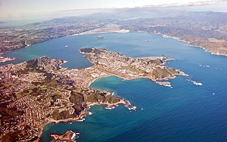
The Kaikōura Peninsula is located in the northeast of New Zealand's South Island. It protrudes 5 kilometres (3.1 mi) into the Pacific Ocean. The town of Kaikōura is located on the north shore of the peninsula. The peninsula has been settled by Maori for approximately 1000 years, and by Europeans since the 1800s, when whaling operations began off the Kaikōura Coast. Since the end of whaling in 1922 whales have been allowed to thrive and the region is now a popular whale watching destination.
The Ruahine Range is the largest of several mountain ranges in the North Island of New Zealand that form a ridge running parallel with the east coast of the island between East Cape and Wellington. The ridge is at its most pronounced from the central North Island down to Wellington, where it comprises the Ruahine, Tararua and Remutaka Ranges.

The Kaikōura District is a territorial authority district in Canterbury Region on the South Island of New Zealand. The district encompasses the eponymous town of Kaikōura, a number of small towns and settlements and the surrounding rural area in northern Canterbury. The district had an estimated population of 4,230 as of June 2023.
Kātiki is a small settlement in North Otago, New Zealand. It lies between the townships of Palmerston and Hampden on State Highway 1 at the northern end of Kātiki Beach, close to the Moeraki Peninsula. The tip of the peninsula, Kātiki Point, is the site of Kātiki Point Lighthouse. The scenic reserve of Trotter's Gorge is located just inland of Kātiki.
Ocean Grove, also known as Tomahawk, is a suburb in the southeast of the New Zealand city of Dunedin. A semi-rural residential suburb on the Pacific coast at the southwestern end of the Otago Peninsula, Ocean Grove is located 6.5 kilometres (4.0 mi) southeast of Dunedin city centre.
The Wharekōpae River is located in the northeast of New Zealand's North Island. A tributary of the Waikohu River, it rises on the slopes of Maungatapere, a 1,050-metre (3,440 ft) peak at the northeastern end of the Huiarau Range, and flows east, reaching the Waikohu River at the settlement of Waikohu, west of Te Karaka.

The Hāpuku River begins in the Seaward Kaikōura Range of New Zealand and flows south-east to enter the South Pacific at Hapuka, between Clarence and Kaikōura. The name comes from the Māori word hāpuku or hāpuka, a deep-water marine fish. Its main tributary is the Puhi Puhi River.
Waiwera South is a small settlement in the South Island of New Zealand, close to the boundary between the Otago and Southland regions. The settlement is located between Balclutha and Clinton, immediately to the south of State Highway 1, between branches of the Waiwera River and Kaihiku Stream, two minor tributaries of the Clutha River. The South Island Main Trunk railway also runs through the township. The settlement's population is around 100.

The 2016 Kaikōura earthquake was a 7.8 earthquake in the South Island of New Zealand that occurred two minutes after midnight on 14 November 2016 NZDT. Ruptures occurred on multiple faults and the earthquake has been described as the "most complex earthquake ever studied". It has been subsequently modelled as having a megathrust component set off by an adjacent rupture on the Humps Fault. It was the second largest earthquake in New Zealand since European settlement.
Tariki is a small farming community immediately to the east of Mount Taranaki in the west of New Zealand's North Island. It lies on SH 3 halfway between the towns of Inglewood and Stratford. Several small streams, all tributaries of the Manganui River, pass close to Tariki.
Waipapakauri is a small settlement in the Far North District of New Zealand. It is located on State Highway 1 at the isthmus of the Aupouri Peninsula. The larger settlement of Awanui lies to the southeast. Waipapakauri is some 12 kilometres to the north of Kaitaia, the nearest town.
The Kaikōura Canyon is a geologically active submarine canyon located southwest of the Kaikōura Peninsula off the northeastern coast of the South Island of New Zealand. It is 60 kilometres (37 mi) long, and is generally U-shaped. The canyon descends into deep water and merges into an ocean channel system that can be traced for hundreds of kilometres across the deep ocean floor. At the head of the Kaikōura Canyon, the depth of water is around 30 metres (98 ft), but it drops rapidly to 600 metres (2,000 ft) and continues down to around 2,000 metres (6,600 ft) deep where it meets the Hikurangi Channel. Sperm whales can be seen close to the coast south of Goose Bay, because the deep water of the Kaikōura Canyon is only one kilometre (0.62 mi) off the shoreline in this area.

Little Akaloa is a small settlement and bay on Banks Peninsula, in the South Island of New Zealand.
