
Passau is a town in Lower Bavaria, Germany, also known as the Dreiflüssestadt because the Danube is joined there by the Inn from the south and the Ilz from the north.

The Bavarian Forest is a wooded, low-mountain region in Bavaria, Germany that is about 100 kilometres long. It runs along the Czech border and is continued on the Czech side by the Bohemian Forest. Most of the Bavarian Forest lies within the province of Lower Bavaria, but the northern part lies within Upper Palatinate. In the south it reaches the border with Upper Austria.

The Bavarian Forest National Park is a national park in the Eastern Bavarian Forest immediately on Germany's border with the Czech Republic. It was founded on 7 October 1970 as the first national park in Germany. Since its expansion on 1 August 1997 it has covered an area of 24,250 hectares. Together with the neighbouring Czech Bohemian Forest the Bavarian Forest forms the largest contiguous area of forest in Central Europe. It should not be confused with the Bavarian Forest Nature Park.
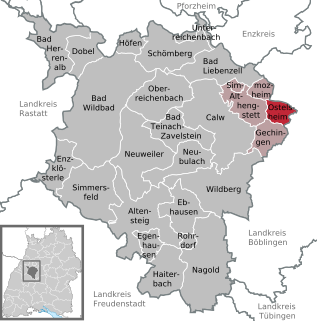
Ostelsheim is a municipality in the district of Calw in Baden-Württemberg in Germany.
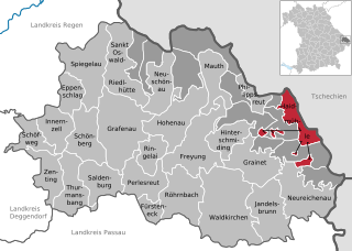
Haidmühle is a municipality in the district of Freyung-Grafenau in Bavaria in Germany.
Neuschönau is a municipality in the district of Freyung-Grafenau, in the Lower Bavaria region of Bavaria, in Germany.

Saldenburg is a municipality in the district of Freyung-Grafenau in Bavaria in Germany.
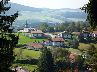
Spiegelau is a municipality in the district of Freyung-Grafenau in Bavaria in Germany. It lies in the heart of the Bavarian Forest.

Zenting is a municipality in the district of Freyung-Grafenau in Bavaria in Germany.

Lindberg is a municipality in the district of Regen in Bavaria in Germany in the immediate neighbourhood of the larger town Zwiesel.

Wegscheid is a municipality in the district of Passau in Bavaria in Germany.

Tutow is a municipality in the Vorpommern-Greifswald district, in Mecklenburg-Vorpommern, Germany.

Schardenberg is a municipality in the district of Schärding in the Austrian state of Upper Austria.
The building of the Zwiesel–Grafenau railway, today route number 906 in the timetable, was begun in 1884 by the Royal Bavarian State Railways and taken into service on 1 September 1890. With a total length of 32 km it linked the towns of Zwiesel and Grafenau in the Bavarian Forest. At Zwiesel railway station it connects to the Bavarian Forest railway from Plattling to Bayerisch Eisenstein, built by the Bavarian Ostbahn and opened on 16 September 1877, as well as the line to Bodenmais opened on 3 September 1928.

The Passau–Freyung railway, also known as the Ilz Valley Railway or Ilztalbahn, is a branch line in Bavaria, Germany. It runs from Passau to the town of Freyung in the Bavarian Forest. At Kalteneck it forms a junction with the branch line to Eging-Deggendorf. At Waldkirchen the Waldkirchen–Haidmühle line branches off towards the Czech border, where since 1945 there has been a junction with the Czech railway network.

The Spiegelau Forest Railway was a 600 mm narrow gauge forest railway built for the transportation of logs from the woods around Spiegelau in the Bavarian Forest in southern Germany.

Seen from the River Danube, the Brotjacklriegel is the first high mountain in the Bavarian Forest. It is 1,011 m above NHN and lies in the county of Freyung-Grafenau in the German federal state of Bavaria. It is a symbol of the Sonnenwald region which comprises the municipalities of Schöfweg, Zenting, Innernzell, Grattersdorf and Market Schöllnach.

The Dreisesselberg is a mountain in Bavaria, Germany, in the Bavarian Forest that is 1,333 metres high.

The Neuburg Forest is a largely forested hill ridge and natural region in Lower Bavaria in the county of Passau and the borough of Passau. It is named after the village of Neuburg am Inn.


