Oberreute

Last updated
Oberreute
Oberstaufen - Vorderreute nw - Oberreute v O, Tatzen.JPG
Oberreute seen from the east
DEU Oberreute COA.svg
Coat of arms
Location of Oberreute within Lindau district
Oberreute in LI.svg
Germany adm location map.svg
Red pog.svg
Oberreute
Bavaria location map.svg
Red pog.svg
Oberreute
Coordinates: 47°34′N9°56′E / 47.567°N 9.933°E / 47.567; 9.933 Coordinates: 47°34′N9°56′E / 47.567°N 9.933°E / 47.567; 9.933
Country Germany
State Bavaria
Admin. region Schwaben
District Lindau
Municipal assoc. Stiefenhofen
Government
   Mayor (202026) Stefan Schneider [1]
Area
  Total13.49 km2 (5.21 sq mi)
Highest elevation
1,041 m (3,415 ft)
Lowest elevation
860 m (2,820 ft)
Population
 (2020-12-31) [2]
  Total1,653
  Density120/km2 (320/sq mi)
Time zone UTC+01:00 (CET)
  Summer (DST) UTC+02:00 (CEST)
Postal codes
88179
Dialling codes 08387
Vehicle registration LI
Website www.oberreute.de

Oberreute is a municipality in the district of Lindau in Bavaria in Germany and member of the municipal association of Stiefenhofen. It is an acknowledged air health resort.

Contents

Geography

Oberreute is located in the Allgäu region, on the border with Austria.

History

The contemporary districts of Stadels and Schönebühl once were seat of a court. Oberreute was not formed until the end of the 18th century. In 1797 the first church was built by inhabitants. The town had been part of the Austrian authority of Bregenz-Hohenegg. Since the signing of the peace treaties of Brünn and Preßburg in 1805 the municipality belongs to Bavaria.

Population development

In 1970 1,040, in 1987 1,283 and in 2000 1,471 inhabitants were living in the municipality of Oberreute.

Politics

The mayor of the town is Stefan Schneider.

The revenue from the municipal tax added up to 693,000 € in 1999, of which the net business tax amounted to 101,000 €.

Economy and infrastructure

Economy, agriculture and forestry

According to the official statistics, in 1998 there were neither employees who were subject to social insurance contribution in the industrial sector, nor in the sector of trade and transport at place of work. At place of domicile there were 459 employees altogether. In the industrial sector there were six, in the main construction trade two businesses. Moreover, there were 54 agricultural businesses in 1999 with a total area of 881 ha.

Education

In 1999 there were the following institutions:

Related Research Articles

Geiselwind Place in Bavaria, Germany

Geiselwind is a market town in Lower Franconia (Bavaria) in the district of Kitzingen in Germany. It has a population of around 2,300.

Heinrichsthal Place in Bavaria, Germany

Heinrichsthal is a community in the Aschaffenburg district in the Regierungsbezirk of Lower Franconia (Unterfranken) in Bavaria, Germany, and a member of the Verwaltungsgemeinschaft of Heigenbrücken.

Emmering, Ebersberg Place in Bavaria, Germany

Emmering is a community in the Upper Bavarian district of Ebersberg. It is a member of the administrative community (Verwaltungsgemeinschaft) of Aßling.

Röthenbach (Allgäu) Place in Bavaria, Germany

Röthenbach (Allgäu) is a municipality in the administrative region of Swabia Lindau district and seat of the municipal association Röthenbach.

Bodolz Place in Bavaria, Germany

Bodolz is a municipality in the district of Lindau in Bavaria in Germany.

Gestratz Place in Bavaria, Germany

Gestratz is a municipality in the district of Lindau in Bavaria in Germany.

Grünenbach Place in Bavaria, Germany

Grünenbach is a municipality in the district of Lindau in Bavaria in Germany.

Heimenkirch Place in Bavaria, Germany

Heimenkirch is a municipality in the district of Lindau in Bavaria in Germany.

Hergensweiler Place in Bavaria, Germany

Hergensweiler is a municipality in the district of Lindau in Bavaria in Germany. It is member of the municipal association of Sigmarszell.

Maierhöfen Place in Bavaria, Germany

Maierhöfen is a municipality in the district of Lindau in Bavaria in Germany.

Nonnenhorn Place in Bavaria, Germany

Nonnenhorn is one of the three Bavarian towns on Lake Constance in the Swabian district of Lindau. The air health resort and famous wine town is located between Wasserburg (Bodensee) and Kressbronn am Bodensee (Baden-Württemberg).

Opfenbach Place in Bavaria, Germany

Opfenbach is a municipality in the district of Lindau in Bavaria in Germany.

Birkenfeld, Bavaria Place in Bavaria, Germany

Birkenfeld is a community in the Main-Spessart district in the Regierungsbezirk of Lower Franconia (Unterfranken) in Bavaria, Germany and a member of the Verwaltungsgemeinschaft of Marktheidenfeld.

Bischbrunn Place in Bavaria, Germany

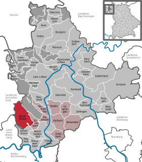
Bischbrunn is a community with around 1,800 (2013) inhabitants in the Main-Spessart district in the Regierungsbezirk of Lower Franconia (Unterfranken) in Bavaria, Germany and a member of the Verwaltungsgemeinschaft of Marktheidenfeld.

Gräfendorf Place in Bavaria, Germany

Gräfendorf is a community in the Main-Spessart district in the Regierungsbezirk of Lower Franconia (Unterfranken) in Bavaria, Germany and a member of the Verwaltungsgemeinschaft of Gemünden am Main.

Karbach, Bavaria Place in Bavaria, Germany

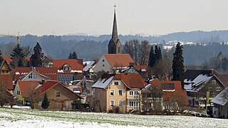
Karbach is a market community in the Main-Spessart district in the Regierungsbezirk of Lower Franconia (Unterfranken) in Bavaria, Germany and a member of the Verwaltungsgemeinschaft of Marktheidenfeld.

Karsbach Place in Bavaria, Germany

Karsbach is a municipality in the Main-Spessart district in the Regierungsbezirk of Lower Franconia (Unterfranken) in Bavaria, Germany and a member of the Verwaltungsgemeinschaft of Gemünden am Main.

Schneeberg, Bavaria Place in Bavaria, Germany

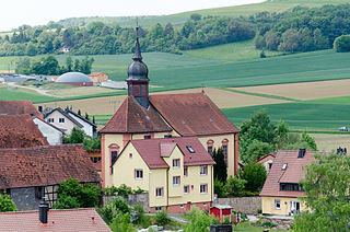
Schneeberg is a market municipality in the Miltenberg district in the Regierungsbezirk of Lower Franconia (Unterfranken) in Bavaria, Germany.

Mitterskirchen Place in Bavaria, Germany

Mitterskirchen is a municipality in the district of Rottal-Inn in Bavaria in Germany.

Zeilarn Place in Bavaria, Germany

Zeilarn is a municipality in the district of Rottal-Inn in Bavaria, Germany.

References

  1. Liste der ersten Bürgermeister/Oberbürgermeister in kreisangehörigen Gemeinden, Bayerisches Landesamt für Statistik, 15 July 2021.
  2. "Tabellenblatt "Daten 2", Statistischer Bericht A1200C 202041 Einwohnerzahlen der Gemeinden, Kreise und Regierungsbezirke". Bayerisches Landesamt für Statistik und Datenverarbeitung (in German). June 2021.