
A tsunami is a series of waves in a water body caused by the displacement of a large volume of water, generally in an ocean or a large lake. Earthquakes, volcanic eruptions and underwater explosions above or below water all have the potential to generate a tsunami. Unlike normal ocean waves, which are generated by wind, or tides, which are in turn generated by the gravitational pull of the Moon and the Sun, a tsunami is generated by the displacement of water from a large event.
Crescent City is the only incorporated city in Del Norte County, California; it is also the county seat. Named for the crescent-shaped stretch of sandy beach south of the city, Crescent City had a total population of 6,673 in the 2020 census, down from 7,643 in the 2010 census.

Ocean Shores is a city in Grays Harbor County, Washington, United States. The population was 6,715 at the 2020 census, and according to 2023 census estimates, the city is estimated to have a population of 7,549.

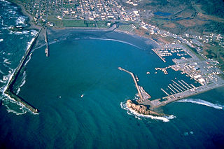
Westport is a city in Grays Harbor County, Washington, United States. It had a population of 2,213 at the 2020 census. Westport is located on a peninsula on the south side of the entrance to Grays Harbor from the Pacific Ocean.

Tokeland is a census-designated place (CDP) in Pacific County, Washington, United States. The population was 158 at the 2020 census, a slight increase from 151 at the 2010 census. It is located on the north side of Willapa Bay near the Shoalwater Bay Indian Reservation.

The 1964 Alaska earthquake, also known as the Great Alaska earthquake and Good Friday earthquake, occurred at 5:36 PM AKST on Good Friday, March 27, 1964. Across south-central Alaska, ground fissures, collapsing structures, and tsunamis resulting from the earthquake caused about 131 deaths.
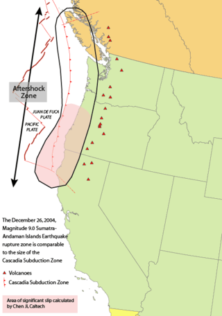
The 1700 Cascadia earthquake occurred along the Cascadia subduction zone on January 26, 1700, with an estimated moment magnitude of 8.7–9.2. The megathrust earthquake involved the Juan de Fuca plate from mid-Vancouver Island, south along the Pacific Northwest coast as far as northern California. The plate slipped an average of 20 meters (66 ft) along a fault rupture about 1,000 kilometers long.
Namie is a town located in Fukushima Prefecture, Japan. As of 29 February 2020 the town has a population of 1,238 in 794 households, although the official registered population was 17,114 in 6853 households. The total area of the town is 223.14 square kilometres (86.15 sq mi). The town was evacuated as a result of the Fukushima Daiichi nuclear disaster—being directly downwind from the power plant—and was within the exclusion zone set up in response to the disaster. Following ongoing clean-up efforts, Namie's business district and town hall have reopened, but access to more heavily contaminated western parts of the town remains restricted as decontamination continues to be carried out.

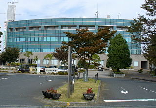
Onagawa is a town located in Miyagi Prefecture, Japan. As of 30 April 2020, the town had an estimated population of 6,319, and a population density of 97 persons per km2 in 3,110 households. The total area of the town is 65.35 square kilometres (25.23 sq mi).
Sasquatch Books LLC is an American book publishing company based in Seattle, Washington. It was founded in 1986 by David Brewster of the Seattle Weekly and primarily publishes nonfiction books about the western United States and Canada and cover topics such as nature, travel, gardening, entertainment, sports, food and wine. By 2003, it was publishing approximately 30 books per year and employed 18 people. In 2020, it launched a new imprint for young adult nonfiction called Spruce Books.

The Onagawa Nuclear Power Plant genshiryoku hatsudensho, Onagawa NPP) is a nuclear power plant located on a 1,730,000 m2 site in Onagawa in the Oshika District and Ishinomaki city, Miyagi Prefecture, Japan. It is managed by the Tohoku Electric Power Company. It was the most quickly constructed nuclear power plant in the world.
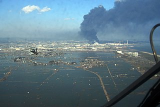
On 11 March 2011, at 14:46:24 JST, a 9.0–9.1 undersea megathrust earthquake occurred in the Pacific Ocean, 72 km (45 mi) east of the Oshika Peninsula of the Tōhoku region. It lasted approximately six minutes and caused a tsunami. It is sometimes known in Japan as the "Great East Japan Earthquake", among other names. The disaster is often referred to by its numerical date, 3.11.
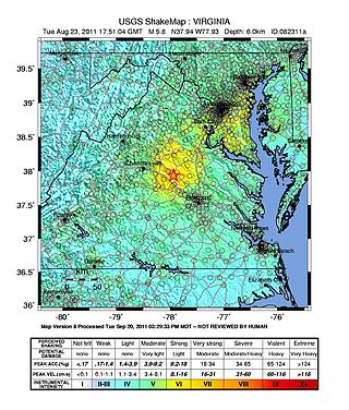
On August 23, 2011, a magnitude 5.8 earthquake hit the Piedmont region of the U.S. state of Virginia at 1:51:04 p.m. EDT. The epicenter, in Louisa County, was 38 mi (61 km) northwest of Richmond and 5 mi (8 km) south-southwest of the town of Mineral. It was an intraplate earthquake with a maximum perceived intensity of VIII (Severe) on the Mercalli intensity scale. Several aftershocks, ranging up to 4.5 in magnitude, occurred after the main tremor.

Vertical and horizontal evacuation are strategies for providing safety to humans in case of tsunami, hurricane or other natural disaster.
Ocosta School District No. 172 is a rural school district in Grays Harbor County, Washington and neighboring Pacific County. The school district serves Westport, Cohassett Beach, Grayland, Markham and Tokeland.

On January 23, 2018, at 00:31 AKST, an earthquake occurred in the Gulf of Alaska near Kodiak Island. The earthquake, measured at 7.9 on the scale, was approximately 280 kilometers (170 mi) southeast of Kodiak and happened at a depth of 25 kilometers (16 mi).

Odisha State Disaster Management Authority is an agency of the Department of Revenue & Disaster Management whose primary purpose is to carry out responses to natural or man-made disasters and for capacity-building in disaster resiliency and crisis response. It was established as the Odisha State Disaster Mitigation Authority by a resolution of the Department of Finance of the Government of Odisha on 28 December 1999, as a response to the death toll and damage caused by a 1999 supercyclone. The chief secretary of Government of Odisha is the ex-officio chairperson of the governing body of the authority.

At 02:10 PM local time (UTC-5) on 28 January 2020, an earthquake with a magnitude of 7.7 struck the north side of the Cayman Trough, north of Jamaica and west of the southern tip of Cuba, with the epicenter being 80 miles (130 km) east-southeast of Cayman Brac, Cayman Islands, and 83 miles (134 km) north of Montego Bay, Jamaica. Schools in Jamaica, as well as corporate and public buildings in Miami, were evacuated after shaking was experienced in parts of the U.S. state of Florida, a region not typically thought of in-relation to seismic activity. Light shaking was also reported on the Yucatán Peninsula in Mexico. The quake was the largest seismic event in the Caribbean since 1946. A tsunami warning for the Caribbean Sea was initially issued by the Pacific Tsunami Warning Center, later being withdrawn.

Sandi Doughton is an American author and science journalist for The Seattle Times.

Okawa Elementary School was an educational institution in Ishinomaki City, Miyagi Prefecture, Japan. The school was destroyed in the 2011 Tōhoku earthquake and tsunami. 74 of its 108 students, who had been sheltering in the school on the instructions of their teachers rather than evacuating to higher ground, were killed as the tsunami ran up the nearby Kitakami River. Only four of the students present when the tsunami struck the school survived. Ten of the school's eleven teachers also died. It was found that the school was unprepared for such an event, and that the scale of the tsunami had not been realized until it was too late.


