Ohio State Route 312

Last updated

OH-312.svg

State Route 312
OH 312 map.svg
Route information
Maintained by ODOT
Length 9.14 mi [1] (14.71 km)
Existed 1932 [2] [3] – present
Major junctions
South endOH-93.svg SR 93 near Logan
North endOH-664.svg SR 664 near Bremen
Location
Counties Hocking, Perry, Fairfield
Highway system
OH-311 (1960).svg SR 311 SR 313 OH-313.svg

State Route 312 (SR 312) is a northsouth state highway located in the southern portion of the U.S. state of Ohio. SR 312 runs from its southern terminus at a T-intersection with SR 93 approximately 4.25 miles (6.84 km) northeast of Logan to its northern terminus at a T-intersection with SR 664 nearly 1.25 miles (2.01 km) south of Bremen.

A state highway, state road, or state route is usually a road that is either numbered or maintained by a sub-national state or province. A road numbered by a state or province falls below numbered national highways in the hierarchy. Roads maintained by a state or province include both nationally numbered highways and un-numbered state highways. Depending on the state, "state highway" may be used for one meaning and "state road" or "state route" for the other.

U.S. state constituent political entity of the United States

In the United States, a state is a constituent political entity, of which there are currently 50. Bound together in a political union, each state holds governmental jurisdiction over a separate and defined geographic territory and shares its sovereignty with the federal government. Due to this shared sovereignty, Americans are citizens both of the federal republic and of the state in which they reside. State citizenship and residency are flexible, and no government approval is required to move between states, except for persons restricted by certain types of court orders. Four states use the term commonwealth rather than state in their full official names.

Ohio State of the United States of America

Ohio is a Midwestern state in the Great Lakes region of the United States. Of the fifty states, it is the 34th largest by area, the seventh most populous, and the tenth most densely populated. The state's capital and largest city is Columbus.

Contents

SR 312 was created in the early 1930s. Its generally maintained its same routing for the entirety of its history, excepting the first five years of its existence when it continued north along SR 664 a short distance through Bremen before coming to an end at SR 37. This two-lane highway traverses rural territory for its entire length.

Ohio State Route 37 highway in Ohio

State Route 37 is a northwest-southeast highway in Ohio. It is the ninth longest state route in Ohio. Its western terminus is at U.S. Route 224 and SR 12 in Findlay, and its eastern terminus is at SR 60 and SR 78 in McConnelsville.

Route description

Along its way, SR 312 traverses a very small portion of Hocking County, cuts across the southwestern most part of Perry County and enters into the southeastern corner of Fairfield County.

Hocking County, Ohio County in the United States

Hocking County is a county located in the U.S. state of Ohio. As of the 2010 census, the population was 29,380. Its county seat is Logan. The county was organized on March 1, 1818, from land given by Athens, Fairfield, and Ross counties. Its name is from the Hocking River, the origins of which are disputed but is said to be a Delaware Indian word meaning "bottle river".

Perry County, Ohio County in the United States

Perry County is a county located in the U.S. state of Ohio. As of the 2010 census, the population was 36,058. Its county seat is New Lexington. Founded on March 1, 1818, from parts of Fairfield, Washington and Muskingum counties, it was the 55th county to be formed in Ohio. The county is named for Oliver Hazard Perry, a hero of the War of 1812.

Fairfield County, Ohio County in the United States

Fairfield County is a county located in the U.S. state of Ohio. As of the 2010 census, the population was 146,156. Its county seat is Lancaster. Its name is a reference to the Fairfield area of the original Lancaster.

SR 312 begins at a T-intersection with SR 93 in Hocking County's Falls Township at a location approximately 4.25 miles (6.84 km) northeast of Logan. The initial stretch of this state highway features it traveling to the northwest amidst a wooded landscape. After a distance of just 0.40 miles (0.64 km), the route departs Hocking County and passes into Perry County. [4]

Falls Township, Hocking County, Ohio Township in Ohio, United States

Falls Township is one of the eleven townships of Hocking County, Ohio, United States. As of the 2010 census the population was 11,731, of whom 5,209 lived in the unincorporated portions of the township.

Now in Monday Creek Township, SR 312 continues to travel in a northwesterly direction through gently rolling hills, with forested land providing the predominant backdrop, but the occasional patch of open field appears along the way, along with a few houses. The highway passes Township Road 245 and travels a distance before passing through a reverse curve that takes it to the northeast before turning to the north-northwest. It next meets Griggs Road, then intersects Township Road 248 as it curves back to the north-northeast. SR 312 gradually starts arcing back to the northwest prior to meeting Township Road 430 at a split intersection, with the eastern leg meeting the state highway just prior to where the western leg meets it. After a short distance, SR 312 crosses Township Road 372, and passes into Jackson Township. The landscape becomes more open in this area in the immediate vicinity of the highway, with woods dwelling further in the background. Following a northwesterly trend as it passes through the southwestern part of the township, the state route meets Van Horn Road, and a short distance later, enters into Fairfield County. [4]

Monday Creek Township, Perry County, Ohio Township in Ohio, United States

Monday Creek Township is one of the fourteen townships of Perry County, Ohio, United States. The 2000 census found 671 people in the township.

Jackson Township, Perry County, Ohio Township in Ohio, United States

Jackson Township is one of the fourteen townships of Perry County, Ohio, United States. The 2000 census found 2,791 people in the township, 1,973 of whom lived in the unincorporated portions of the township.

As it enters Rush Creek Township, SR 312 travels to the northwest, continuing amidst primarily open fields with houses appearing along the way, and woods situated further back. The route bends to the west-northwest prior to the split intersection it has with Bethel Road, with the southern leg intersecting first, followed shortly thereafter by the northern leg. Next, SR 312 passes through a sharp reverse curve that takes the highway north and then back to the west as McCullough Road splits off to the north. After intersecting Fairview Road, the state highway turns to the northwest, then bends to the west-northwest before meeting Geneva School Road. Shortly after that point, SR 312 comes to an end as it arrives at the T-intersection it has with SR 664, which forms the southern and western legs of intersection as SR 312 enters from the east. [4]

Rush Creek Township, Fairfield County, Ohio Township in Ohio, United States

Rush Creek Township is one of the thirteen townships of Fairfield County, Ohio, United States. As of the 2010 census the population was 3,893, of whom 2,468 lived in the unincorporated portions of the township.

SR 312 is not included as a part of the National Highway System. [5]

History

The designation of SR 312 took place in 1932. The original path of SR 312 incorporated all of its current routing, along with the portion of SR 664 that runs between SR 312 and SR 37 just north of the village limits of Bremen. [2] [3] When SR 664 was introduced in 1937, SR 312's northern terminus was moved from SR 37 south to its current location, as the SR 664 designation replaced that of SR 312 from there through Bremen to the SR 37 intersection, and then continuing north of where SR 312 had formerly ended. [6] [7]

Major intersections

CountyLocationmi [1] kmDestinationsNotes
Hocking Falls Township 0.000.00OH-93.svg SR 93  New Straitsville, Logan
Perry
No major junctions
Fairfield Rush Creek Township 9.1414.71OH-664.svg SR 664
1.000 mi = 1.609 km; 1.000 km = 0.621 mi

Related Research Articles

Ohio State Route 281 highway in Ohio

State Route 281 is an east–west state highway in the northwestern portion of the U.S. state of Ohio. Its western terminus is at U.S. Route 24 approximately four miles (6.4 km) northeast of downtown Defiance, and its eastern terminus is at US 6 nearly one mile (1.6 km) north of Bradner. The majority of the route is known as the Defiance Pike.

Ohio State Route 532 highway in Ohio

State Route 532 is a north–south state highway in the northeastern portion of the U.S. state of Ohio. The highway runs from its southern terminus at a signalized intersection with U.S. Route 224 (US 224) on the Summit–Portage county line approximately 0.75 miles (1.21 km) south of Mogadore on the border of Springfield Township and Suffield Township to its northern terminus at a diamond interchange with Interstate 76 (I-76), at its exit 29 within the Tallmadge city limits.

Ohio State Route 287 highway in Ohio

State Route 287 (SR 287) is a 13.69-mile-long (22.03 km) east–west state highway in the western portion of the U.S. state of Ohio. The western terminus of SR 287 is at SR 245 nearly 1.75 miles (2.82 km) east of West Liberty. Its eastern terminus is at an interchange with U.S. Route 33 (US 33) about 5.25 miles (8.45 km) northeast of North Lewisburg that dually serves as the southern terminus of SR 739.

Ohio State Route 797 highway in Ohio

State Route 797 was a very short, unsigned north–south state highway in the eastern portion of the U.S. state of Ohio. At the time of its deletion of the route from the state highway system, SR 797 ran from its southern terminus at the U.S. Route 22/U.S. Route 40 concurrency about 4.75 miles (7.64 km) northeast of Zanesville to its northern terminus less than 0.40 miles (0.64 km) to the northwest at Interstate 70 at its exit 160, a diamond interchange. North of the interchange, the road continues to Sonora on Muskingum County Road 52, Sonora Road.

Ohio State Route 621 highway in Ohio

State Route 621 is a north–south state highway in the central part of the U.S. state of Ohio. The southern terminus of SR 621 is at U.S. Route 36 approximately two and a half miles (4.0 km) northeast of Coshocton, and its northern terminus is adjacent to the North Appalachian Experimental Watershed Station, just north of its intersection with White Eyes Township Road 188, about 5 miles (8.0 km) northwest of the hamlet of Fresno. Continuing north after SR 621 ends is County Road 190.

Ohio State Route 546 highway in Ohio

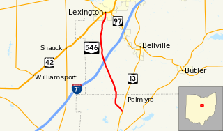
State Route 546 is a north–south state highway in the northern portion of the U.S. state of Ohio. The southern terminus of SR 546 is at a T-intersection with SR 13 nearly two and a half miles (4.0 km) north of Fredericktown. Its northern terminus is at a signalized intersection with the U.S. Route 42 (US 42)/SR 97 concurrency in Lexington.

Ohio State Route 288 highway in Ohio

State Route 288 (SR 288) is a 6.82-mile (10.98 km) long east–west state highway in the northern portion of the U.S. state of Ohio. The western terminus of SR 288 is at a T-intersection with SR 309 about 3 miles (4.8 km) southwest of Galion. Its eastern terminus is also at a T-intersection, this time with SR 97 approximately 5.50 miles (8.85 km) northwest of Lexington.

Ohio State Route 664 highway in Ohio

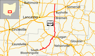
State Route 664 is a north–south state highway in the southern portion of the U.S. state of Ohio. The highway has its southern terminus at a T-intersection with SR 56 in the unincorporated community of South Bloomingville. The northern terminus of SR 664 is also at a T-intersection, this time with SR 256 on the Fairfield–Perry county line approximately 4.75 miles (7.64 km) north of the village of Rushville.

Ohio State Route 211 highway in Ohio

State Route 211 (SR 211) is a 1.23-mile-long (1.98 km) north–south state highway in the eastern portion of the U.S. state of Ohio. Though physically it runs in a northwesterly–southeasterly direction, according to the Ohio Department of Transportation (ODOT) and signage on the route itself its southern terminus is located north of its northern terminus. The unusual directional signage is a vestige of when SR 211 traveled further south acting as a bypass of New Philadelphia and Dover. The highway runs from its signed southern terminus at a signalized intersection with SR 39 on the border of the city of Dover and Dover Township, just one block east of exit 83 off the Interstate 77 (I-77)/U.S. Route 250 (US 250) freeway, to its signed northern terminus at a signalized intersection with SR 800 near downtown Dover.

Ohio State Route 212 highway in Ohio

State Route 212 is a two-lane east–west state highway that runs within Stark, Tuscarawas, Carroll, and Harrison Counties in eastern Ohio. The western terminus of SR 212 is at U.S. Route 250 near Beach City, and its eastern terminus is at SR 151 in Bowerston. The route passes through rural areas but passes through small villages including Beach City, Bolivar, Zoar, Sherrodsville, and Leesville. It largely follows the valleys formed by the Tuscarawas River and Conotton Creek.

Ohio State Route 606 highway in Ohio

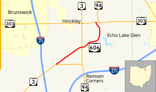
State Route 606 is a north–south state highway in the northeastern quadrant of the U.S. state of Ohio. The southern terminus of SR 606 is at a T-intersection with SR 3 approximately 4.50 miles (7.24 km) northeast of Medina. The highway's northern terminus is at another T-intersection, this time with the SR 94/SR 303 concurrency nearly 3.25 miles (5.23 km) west of Richfield.

Ohio State Route 672 highway in Ohio

State Route 672 (SR 672) is a 3.11-mile-long (5.01 km) east–west state highway in the southeastern part of the U.S. state of Ohio. The highway runs from its western terminus at a Y-intersection with SR 146 nearly 1.75 miles (2.82 km) northeast of Cumberland to its eastern terminus at a T-intersection with SR 821 about 3 miles (4.8 km) southwest of the village of Pleasant City.

Ohio State Route 374

State Route 374 is north–south state highway in Hocking County, Ohio, located in the southern portion of the state. Its southern terminus is over 4 miles (6.4 km) east of the unincorporated village of South Bloomingville at State Route 56, and its northern terminus is near the unincorporated village of Rockbridge at US 33, west of Logan. The road serves Hocking State Forest as well as Hocking Hills State Park, and the entire highway is part of the designated Hocking Hills Scenic Byway.

Ohio State Route 771

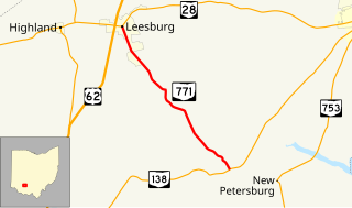
State Route 771 is a 7.11-mile-long (11.44 km) state highway located entirely in Highland County, Ohio. The north–south route connects SR 138 in Paint Township and SR 28 in Leesburg.

Ohio State Route 646

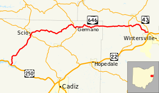
State Route 646 is a 28.78-mile-long (46.32 km) state highway in Harrison and Jefferson Counties in eastern Ohio. The route runs from US 250 in Stock Township, northwest of Cadiz, to SR 43 in Island Creek Township, just outside Wintersville.

Ohio State Route 668

State Route 668 is a north-south state highway in central Ohio. Its southern terminus is at an intersection with SR 93 in the Wayne National Forest, northeast of Logan; its northern terminus is at an intersection with US 40 in the unincorporated community of Brownsville.

Ohio State Route 674

State Route 674 is a state highway located southeast of Columbus, Ohio. Most of the route straddles a county line; about 11 miles (18 km) of the southern part of route is on the Pickaway–Fairfield County line while the next 1.4 miles (2.3 km) is on the Fairfield-Franklin County line. The route's southern terminus is at US 22 just north of Stoutsville while the northern terminus is at an interchange with US 33 in the city of Canal Winchester.

Ohio State Route 729 highway in Ohio

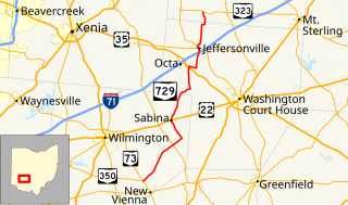
State Route 729 is a state highway in central Ohio. The 33.58-mile-long (54.04 km) route runs from SR 73 and SR 350 in the community of Snow Hill, northwest of New Vienna to SR 323 north of Jeffersonville.

References

Route map: Google

KML file (edithelp)
KML is from Wikidata
  1. 1 2 "DESTAPE". Ohio Department of Transportation. June 24, 2015. Retrieved November 1, 2015.
  2. 1 2 Map of Ohio Showing State Highway System (MrSID) (Map). Cartography by ODOH. Ohio Department of Highways. 1931. Retrieved 2011-02-20.
  3. 1 2 Map of Ohio Showing State Highway System (MrSID) (Map). Cartography by ODOH. Ohio Department of Highways. 1932. Retrieved 2011-02-20.
  4. 1 2 3 Google (November 1, 2015). "Ohio State Route 312" (Map). Google Maps . Google. Retrieved November 1, 2015.
  5. National Highway System: Ohio (PDF) (Map). Federal Highway Administration. December 2003. Retrieved 2011-02-20.
  6. Official Ohio Highway Map (MrSID) (Map). Cartography by ODOH. Ohio Department of Highways. 1936. Retrieved 2011-02-20.
  7. Official Ohio Highway Map (MrSID) (Map). Cartography by ODOH. Ohio Department of Highways. 1937. Retrieved 2011-02-20.