Ohio State Route 320

Last updated

OH-320.svg

State Route 320
OH 320 map.svg
Route information
Maintained by ODOT
Length 3.12 mi [1] (5.02 km)
Existed 1932 [2] [3] – present
Major junctions
South endUS 35.svg US 35 near New Paris
 US 40.svg US 40 near New Paris
North endOH-121.svg SR 121 in New Paris
Location
Counties Preble
Highway system
OH-319.svg SR 319 SR 321 OH-321.svg

State Route 320 (SR 320) is a short northsouth state highway in western Ohio, a U.S. state. The southern terminus of SR 320 is at U.S. Route 35 (US 35) approximately three miles (4.8 km) southeast of New Paris, 34 mile (1.2 km) south of US 35's eastern junction with Interstate 70 (I-70). The northern terminus of the state highway is located in New Paris at a signalized intersection with SR 121.

A state highway, state road, or state route is usually a road that is either numbered or maintained by a sub-national state or province. A road numbered by a state or province falls below numbered national highways in the hierarchy. Roads maintained by a state or province include both nationally numbered highways and un-numbered state highways. Depending on the state, "state highway" may be used for one meaning and "state road" or "state route" for the other.

Ohio State of the United States of America

Ohio is a Midwestern state in the Great Lakes region of the United States. Of the fifty states, it is the 34th largest by area, the seventh most populous, and the tenth most densely populated. The state's capital and largest city is Columbus.

U.S. state constituent political entity of the United States

In the United States, a state is a constituent political entity, of which there are currently 50. Bound together in a political union, each state holds governmental jurisdiction over a separate and defined geographic territory and shares its sovereignty with the federal government. Due to this shared sovereignty, Americans are citizens both of the federal republic and of the state in which they reside. State citizenship and residency are flexible, and no government approval is required to move between states, except for persons restricted by certain types of court orders. Four states use the term commonwealth rather than state in their full official names.

Contents

This L-shaped two-lane highway was first designated in the early 1930s along the stretch between Preble County Road 335 (CR 335) and SR 121. The highway was extended some three decades later along the former US 35 to its current southern terminus when the U.S. highway was re-routed onto the newly constructed I-70 freeway nearby. The northsouth portion of SR 320 between New Westville and New Paris runs in parallel to the east of the Indiana state line by a distance of just more than one mile (1.6 km). No direct access is provided between SR 320 and I-70/US 35. Consequently, one may access I-70 westbound from SR 320 via US 35. To get to I-70 eastbound from SR 320, one must follow CR 335 westbound into Indiana, where it becomes known as Eaton Pike, and connect to US 40 to access the freeway in the eastbound direction.

Indiana State of the United States of America

Indiana is a U.S. state located in the Midwestern and Great Lakes regions of North America. Indiana is the 38th largest by area and the 17th most populous of the 50 United States. Its capital and largest city is Indianapolis. Indiana was admitted to the United States as the 19th U.S. state on December 11, 1816. Indiana borders Lake Michigan to the northwest, Michigan to the north, Ohio to the east, Kentucky to the south and southeast, and Illinois to the west.

Route description

New Paris, near the northern terminus Washington south of Wrenn, New Paris.jpg
New Paris, near the northern terminus

SR 320 is located entirely within the northwestern corner of Preble County. The route begins at its intersection with US 35 south of where the U.S. route converges with I-70 at the Interstate's westernmost interchange in Ohio in Jackson Township. SR 320 travels to the west-northwest through rural farmland prior to bending to the west into the hamlet of New Westville, where the highway encounters a primarily residential area. At a four-way stop intersection there, SR 320 turns to the north, taking over for New Westville Road while CR 335 is the roadway that departs the intersection to the west. SR 320 now turns to the north-northwest, passing amidst a number of houses prior to crossing over the I-70/US 35 concurrency. To the north of the grade separation, SR 320 travels due north, and is bounded by homes and a large commercial facility on the west side, and farmland on the east side, with some batches of trees appearing along the way. It intersects US 40, then proceeds into Jefferson Township. A combination of woods and homes appear along the west side of the highway at this point, with more farmland abutting it to the east. After a short reverse curve that takes the highway to the northeast and then back to the north, SR 320 encounters forested land on both sides. Upon emerging from the wooded terrain, the highway enters New Paris. As it follows Washington Street northerly through the village, SR 320 passes amidst a blend of commercial businesses and residences leading up to its endpoint in downtown New Paris at a signalized intersection where it meets SR 121. [4] This state highway is not included within the National Highway System. [5]

Preble County, Ohio County in the United States

Preble County is a county located in the U.S. state of Ohio. As of the 2010 census, the population was 42,270. Its county seat is Eaton. The county was formed on February 15, 1808 from portions of Butler and Montgomery Counties. It is named for Edward Preble, a naval officer who fought in the American Revolutionary War and against the Barbary Pirates.

Jackson Township, Preble County, Ohio Township in Ohio, United States

Jackson Township is one of the twelve townships of Preble County, Ohio, United States. The 2000 census found 1,223 people in the township. The Jackson community is served by National Trail High School and the National Trail Local School District. Interstate 70 runs along the northern part of the township.

Concurrency (road) instance of one physical road bearing two or more different highways

A concurrency in a road network is an instance of one physical roadway bearing two or more different route numbers. When two roadways share the same right-of-way, it is sometimes called a common section or commons. Other terminology for a concurrency includes overlap, coincidence, duplex, triplex, multiplex, dual routing or triple routing.

History

SR 320 first appeared in 1932, occupying the current stretch between its intersection with CR 335 (the former routing of US 35, which was originally designated as SR 11) and its current northern terminus at SR 121 in New Paris. [2] [3]

When the current I-70 freeway was constructed going eastward from Indiana into Ohio in 1962, US 35 was re-routed onto the freeway. As a result, SR 320 was extended southeasterly by approximately 0.75 miles (1.21 km) along the former US 35 to the current junction of the two routes. [6] [7]

Major intersections

The entire route is in Preble County.

Locationmi [1] kmDestinationsNotes
Jackson Township 0.000.00US 35.svg US 35  Eaton
1.662.67US 40.svg US 40 (National Road) Lewisburg, Richmond
New Paris 3.125.02OH-121.svg SR 121 (Washington Road / Cherry Street)
1.000 mi = 1.609 km; 1.000 km = 0.621 mi

Related Research Articles

Ohio State Route 184 highway in Ohio

State Route 184 (SR 184) is a 10.14-mile (16.32 km) long east–west state highway in northwestern Ohio, a U.S. state. The western terminus of SR 184 is at the U.S. Route 23 (US 23) freeway in Sylvania, at a five-ramp parclo AB-3 interchange that also serves as the southern terminus of US 223, as well as the northern terminus of SR 51. The eastern terminus of SR 184 is at a diamond interchange with Interstate 75 in Toledo.

Ohio State Route 330 highway in Ohio

State Route 330 is a north–south state highway in the northwestern portion of the U.S. state of Ohio. The southern terminus of SR 330 is at a diamond interchange with the SR 15 expressway just south of the village limits of Vanlue. Its northern terminus is at SR 568 nearly 1.75 miles (2.82 km) north of Vanlue.

Ohio State Route 300 highway in Ohio

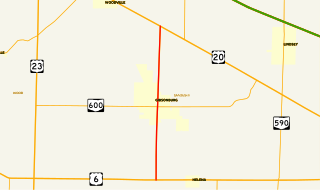
State Route 300 is a 6.33-mile (10.19 km) long north–south state highway in northwestern Ohio, a U.S. state. The southern terminus of SR 300 is at a T-intersection with U.S. Route 6 (US 6) approximately 1.50 miles (2.41 km) west of the village of Helena. Its northern terminus is at US 20 just over 2.50 miles (4.02 km) southeast of Woodville.

Ohio State Route 532 highway in Ohio

State Route 532 is a north–south state highway in the northeastern portion of the U.S. state of Ohio. The highway runs from its southern terminus at a signalized intersection with U.S. Route 224 (US 224) on the Summit–Portage county line approximately 0.75 miles (1.21 km) south of Mogadore on the border of Springfield Township and Suffield Township to its northern terminus at a diamond interchange with Interstate 76 (I-76), at its exit 29 within the Tallmadge city limits.

Ohio State Route 287 highway in Ohio

State Route 287 (SR 287) is a 13.69-mile-long (22.03 km) east–west state highway in the western portion of the U.S. state of Ohio. The western terminus of SR 287 is at SR 245 nearly 1.75 miles (2.82 km) east of West Liberty. Its eastern terminus is at an interchange with U.S. Route 33 (US 33) about 5.25 miles (8.45 km) northeast of North Lewisburg that dually serves as the southern terminus of SR 739.

Ohio State Route 540 highway in Ohio

State Route 540 (SR 540) is an east–west state highway in the western portion of the U.S. state of Ohio. SR 540 has its western terminus in downtown Bellefontaine at a signalized intersection with U.S. Route 68 (US 68) and SR 47. Its eastern terminus is at a T-intersection with SR 292 approximately 3.50 miles (5.63 km) southwest of West Mansfield.

Ohio State Route 797 highway in Ohio

State Route 797 was a very short, unsigned north–south state highway in the eastern portion of the U.S. state of Ohio. At the time of its deletion of the route from the state highway system, SR 797 ran from its southern terminus at the U.S. Route 22/U.S. Route 40 concurrency about 4.75 miles (7.64 km) northeast of Zanesville to its northern terminus less than 0.40 miles (0.64 km) to the northwest at Interstate 70 at its exit 160, a diamond interchange. North of the interchange, the road continues to Sonora on Muskingum County Road 52, Sonora Road.

Ohio State Route 231 highway in Ohio

State Route 231 (SR 231) is a 35.77-mile (57.57 km) long north–south state highway in the northwestern quadrant of the U.S. state of Ohio. SR 231 has its southern terminus at a CSX railroad crossing in the village of Morral. Its northern terminus is in downtown Tiffin at a signalized intersection with SR 18 and SR 101, following a 0.35 miles (0.56 km) long concurrency with SR 100, which continues north as a solo route north of this point.

Ohio State Route 130 highway in Ohio

State Route 130 (SR 130) is a short east–west state route in southwestern Ohio. The entirety of SR 130 lies within Butler County. SR 130 has its western terminus at a signalized intersection with U.S. Route 27 (US 27) in McGonigle. Its eastern terminus is also at a signalized intersection, this time at SR 177 in the extreme northwestern corner of Hamilton. For its entire length, SR 130 is alternately known as Old Oxford Road.

Ohio State Route 503 highway in Ohio

State Route 503 (SR 503) is a north–south state highway in the southwestern quadrant of the U.S. state of Ohio. The southern terminus of SR 503 is at U.S. Route 127 (US 127) in Seven Mile. Its northern terminus is at a T-intersection with SR 121 on the eastern limits of the village of Wayne Lakes.

Ohio State Route 762 highway in Ohio

State Route 762 is an east–west state highway in central Ohio, a U.S. state. The highway has its western terminus at a signalized intersection with the concurrency of U.S. Route 62 and SR 3 just 0.25 miles (0.40 km) south of the village limits of Harrisburg. SR 762's eastern terminus is at an intersection of Pickaway County Route 385 near the Rickenbacker International Airport.

Ohio State Route 185 highway in Ohio

State Route 185 (SR 185) is a 21.70-mile (34.92 km) long east–west state highway in the western part of the U.S. state of Ohio. The western terminus of SR 185 is at U.S. Route 127 (US 127) approximately 3.75 miles (6.04 km) south of North Star. Its eastern terminus is in Piqua. Until 2011, this was at its junction with US 36 and SR 66 in the city's downtown business district, at the intersection of Ash Street and Spring Street. In 2011, SR 185 was re-routed to travel south along Sunset Drive in the western part of Piqua to a new eastern terminus where Sunset Drive meets US 36, which is known as Covington Avenue at that location.

Ohio State Route 122 highway in Ohio

State Route 122 is an Ohio state highway which runs from the Ohio-Indiana state line in Preble County east of Eaton, Ohio to SR 48 near Lebanon, Ohio, a distance of 43.4 miles (69.8 km). When the route was designated in 1923, it ran along its current route from Indiana to Middletown. It was extended to its current eastern terminus in 1937 but was extended further east to U.S. Route 42 in 1946. The route was truncated back to SR 48 by 1985 with the former section being renamed "Old State Route 122" and maintained by Warren County as CR 230. The route also used to continue west of the Indiana state line as Indiana State Road 122 west to its terminus at US 27 east of Abington, Indiana.

Ohio State Route 202 highway in Ohio

State Route 202 (SR 202) is a 20-mile (32 km) north–south state highway in the western part of the U.S. state of Ohio. The highway runs from its southern terminus at an intersection with SR 201 in Dayton to its northern terminus at a T-intersection with SR 55 in the eastern end of Troy.

Ohio State Route 211 highway in Ohio

State Route 211 (SR 211) is a 1.23-mile-long (1.98 km) north–south state highway in the eastern portion of the U.S. state of Ohio. Though physically it runs in a northwesterly–southeasterly direction, according to the Ohio Department of Transportation (ODOT) and signage on the route itself its southern terminus is located north of its northern terminus. The unusual directional signage is a vestige of when SR 211 traveled further south acting as a bypass of New Philadelphia and Dover. The highway runs from its signed southern terminus at a signalized intersection with SR 39 on the border of the city of Dover and Dover Township, just one block east of exit 83 off the Interstate 77 (I-77)/U.S. Route 250 (US 250) freeway, to its signed northern terminus at a signalized intersection with SR 800 near downtown Dover.

Ohio State Route 175 highway in Ohio

State Route 175 (SR 175) is a 15.70-mile (25.27 km) long north–south state highway in the northeastern part of the U.S. state of Ohio. The southern terminus of SR 175 is at a signalized intersection with SR 43 in Solon. Its northern terminus is at a signailzed intersection with SR 283 in Euclid.

Ohio State Route 345 highway in Ohio

State Route 345 (SR 345) is a north–south state highway in the eastern portion of the U.S. state of Ohio. The southern terminus of SR 345 is at a signalized intersection with the SR 13/SR 37 concurrency in New Lexington. Its northern terminus is at a T-intersection with U.S. Route 22 (US 22) in the unincorporated community of East Fultonham.

Ohio State Route 730 highway in Ohio

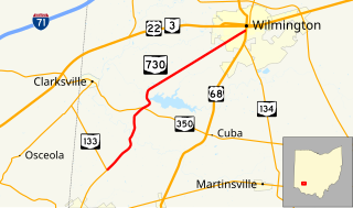
State Route 730 (SR 730) is a 11.45-mile-long (18.43 km) north–south state highway in the southwestern quadrant of the U.S. state of Ohio. The highway travels from its southern terminus at a T-intersection with SR 133 about 2.50 miles (4.02 km) northeast of Blanchester to its northern terminus at a signalized intersection with US 68 and SR 134 in Wilmington.

Ohio State Route 674

State Route 674 is a state highway located southeast of Columbus, Ohio. Most of the route straddles a county line; about 11 miles (18 km) of the southern part of route is on the Pickaway–Fairfield County line while the next 1.4 miles (2.3 km) is on the Fairfield-Franklin County line. The route's southern terminus is at US 22 just north of Stoutsville while the northern terminus is at an interchange with US 33 in the city of Canal Winchester.

Ohio State Route 729 highway in Ohio

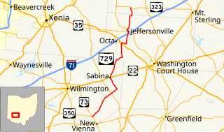
State Route 729 is a state highway in central Ohio. The 33.58-mile-long (54.04 km) route runs from SR 73 and SR 350 in the community of Snow Hill, northwest of New Vienna to SR 323 north of Jeffersonville.

References

Route map: Google

KML file (edithelp)
KML is from Wikidata
  1. 1 2 "DESTAPE - Preble County" (PDF). Ohio Department of Transportation. June 24, 2015. Retrieved November 5, 2015.
  2. 1 2 Map of Ohio Showing State Highway System (MrSID) (Map). Cartography by ODOH. Ohio Department of Highways. 1931. Retrieved 2010-08-19.
  3. 1 2 Map of Ohio Showing State Highway System (MrSID) (Map). Cartography by ODOH. Ohio Department of Highways. 1932. Retrieved 2010-08-19.
  4. Google (November 5, 2015). "Overview Map of State Route 320" (Map). Google Maps . Google. Retrieved November 5, 2015.
  5. National Highway System: Ohio (PDF) (Map). Federal Highway Administration. December 2003. Retrieved 2010-08-19.
  6. Official Ohio Highway Map (MrSID) (Map). Cartography by ODOH. Ohio Department of Highways. 1961. Retrieved 2010-08-19.
  7. Official Ohio Highway Map (MrSID) (Map). Cartography by ODOH. Ohio Department of Highways. 1962. Retrieved 2010-08-19.