
State Route 281 is an east–west state highway in the northwestern portion of the U.S. state of Ohio. Its western terminus is at U.S. Route 24 approximately four miles (6.4 km) northeast of downtown Defiance, and its eastern terminus is at US 6 nearly one mile (1.6 km) north of Bradner. The majority of the route is known as the Defiance Pike.

State Route 844 (SR 844) is a 2.395-mile (3.854 km) state route that runs between Beavercreek and Wright-Patterson Air Force Base in the US state of Ohio. The north–south signed route is a spur freeway which mainly passes through government-owned properties. For some of its path, SR 844 passes through Wright State University. The highway was first signed in 1995 on the same alignment as today. SR 844 replaced the SR 444A designation of the highway, which dated back to 1989.

State Route 44 is a north–south state highway in the northeastern portion of the U.S. state of Ohio. It runs from a southern terminus at State Route 43 in Waynesburg to a northern terminus at the entrance to Headlands Beach State Park near Painesville. spans from Painesville Township in the north to Waynesburg in the south. Various sections of SR 44 are named for individuals.

Ohio State Route 176 is a route linking Interstate 71 (I-71) in Cleveland to I-77 near Richfield. The freeway portion is known as the Jennings Freeway, while the at-grade portion is mostly Broadview Road.

State Route 9 is a north–south route running through four counties in east central Ohio. Its route is 92.5 miles (148.9 km) long. The southern terminus is at SR 148 in Armstrongs Mills and the northern terminus is with US 62 north of Salem.
State Route 10 is a state highway located in and around Cleveland, Ohio. The current routing of SR 10 was certified in 1934. The route's western terminus is in Eaton Township in Lorain County at the junction of U.S. Route 20, State Route 57 and State Route 301, where US 20 and SR 301 continue westbound on the freeway. In North Ridgeville, route 10 merges with Interstate 480 at the interstate's western terminus in North Ridgeville, and continues with the interstate briefly eastward. Just east of this junction, the route also has an interchange with Interstate 80 and the Ohio Turnpike via a connecting or spur road. SR 10 then becomes a grade-level road in North Ridgeville before heading into Cuyahoga County, and is known as Lorain Road. It then continues through the western suburbs of Cleveland and through the western part of Cleveland, as Lorain Avenue, terminating shortly after it crosses the Cuyahoga River on the Hope Memorial Bridge at Gateway at Broadway Avenue/Ontario Street.
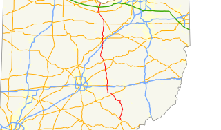
State Route 13 is a north–south state highway in the northern and southeastern portion of the U.S. state of Ohio. It is the tenth longest state route in Ohio. Its southern terminus is at State Route 550 near Athens, and its northern terminus is at U.S. Route 6 in Huron.
State Route 365 (SR 365) is a very short two-lane east–west state highway in western Ohio. It is currently the shortest signed state route in Ohio. Its western terminus is at a T-intersection with the SR 235/SR 366 concurrency one mile (1.6 km) north of the village of Lakeview. After running east and south for less than 980 feet (300 m), the highway arrives at its eastern terminus in Indian Lake State Park, serving a boat launch on the western shore of Indian Lake.
State Route 161 is an east–west state highway in central Ohio. Its western terminus is in Mutual at State Route 29 and its eastern terminus is near Alexandria at State Route 37. It is 57.46 miles (92.47 km) long. State Route 161 passes through Columbus, the capital of Ohio, and a variety of towns including Plain City, Dublin, and New Albany.

State Route 822 is an unsigned east–west state highway in the eastern portion of the U.S. state of Ohio. The short route was designated in 1990. Its western terminus is at the intersection of 7th Street and the on-/off-ramps for U.S. Route 22, where it serves as a connection between the U.S. Route and SR 7, the route's eastern terminus. The whole route is in Steubenville, after multiple truncations due to the demolition of Fort Steuben Bridge.
State Route 54 (SR 54) is a north–south state highway that serves west-central Ohio. It extends from Urbana in the north, to southeast of Springfield.

State Route 605 is a 9.38-mile-long (15.10 km) north–south state highway in central Ohio. The southern terminus of SR 605 is at a signalized intersection with U.S. Route 62 in the northeastern Columbus suburb of New Albany. Its northern terminus is also at SR 37, a signalized intersection approximately 3 miles (4.8 km) southeast of Sunbury. The route was designated in 1937, and the northern terminus was moved in 1994.
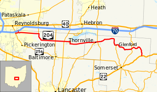
State Route 204 is a state route in central Ohio. It starts at SR 256 in Pickerington, and ends at US 22 near Mount Perry. At a length of 37.79 miles (60.82 km), the route is located parallel to Interstate 70 in Fairfield and Perry counties east of Columbus, the state capital.

State Route 521 is an east–west state highway in central Ohio. Existing entirely within Delaware County, the western terminus of SR 521 is at SR 37 in Delaware. Its eastern terminus is at SR 656 in the hamlet of Olive Green, located approximately five miles (8.0 km) north of Sunbury.

State Route 741 is a north–south state highway in the southwest portion of the U.S. state of Ohio. The southern terminus of the route is at a diamond interchange with I-71 at its Exit 25 near Kings Mills, adjacent to the Kings Island Amusement Park. State Route 741’s northern terminus is at a partial interchange with I-75 at its Exit 50B in Moraine, just south of Dayton.

State Route 364 (SR 364) is a north–south state route in Ohio. It starts from SR 705 near Yorkshire. The route moves north across several counties, then northeast against the side of the Grand Lake. SR 364 then travels west along a concurrency with SR 703, and ends at SR 29 near St. Marys. The route was designated in 1934, from SR 219 to SR 29. It was extended southwards to SR 705 in 1936 and completely paved by 1940. SR 364 was also extended in 1973 to the new alignment of SR 29.
State Route 710 is a 4.06-mile-long (6.53 km) state highway in the central portion of the U.S. state of Ohio. Existing entirely within the northern portion of the city of Columbus, SR 710 begins at an intersection with SR 161, less than one-quarter mile (0.40 km) west of exit 117 off Interstate 71 (I-71). The highway ends at a seven-ramp partial cloverleaf interchange with I-270 at its exit 27.
U.S. Route 6 is a part of the United States Numbered Highway System that runs from Bishop, California to Provincetown, Massachusetts. US 6 is the second longest federal highway in the United States, second only to U.S. Route 20. In Ohio, the road runs west-east from the Indiana state line near Edgerton to the Pennsylvania state line near Andover. The 248.002 miles (399.121 km) that lie in Ohio are maintained by the Ohio Department of Transportation (ODOT). US 6 serves the major cities of Sandusky, Lorain, and Cleveland. The highway is also called the Grand Army of the Republic Highway to honor the Union forces of the American Civil War. The alternate name was designated in 1953.
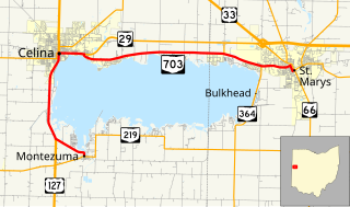
State Route 703 (SR 703) is a state highway in western Ohio. Its western terminus is in Montezuma at SR 219, and its eastern terminus is in St. Marys at an intersection with SR 29, SR 66, and the southern terminus of SR 116 in St. Marys. The route is mainly an east–west highway along the shores of Grand Lake St. Marys, although the section between Celina and Montezuma travels in a more north-south fashion.

State Route 219 is an east–west state highway in the western portion of the U.S. state of Ohio. State Route 219's western terminus is at the Indiana State Line approximately 5.5 miles (8.9 km) northwest of Fort Recovery, with the roadway continuing west into the Hoosier State being County Road 300N. The eastern terminus of State Route 219 is at a diamond interchange with Interstate 75 at its Exit 104 in Botkins.

