New Madison, Ohio

Last updated

New Madison, Ohio
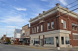
Main from Washington, New Madison.jpg
Darke County Ohio incorporated and unincorporated areas New Madison highlighted.svg
Location in Darke County and the state of Ohio.
Coordinates: 39°58′02″N84°42′29″W / 39.96722°N 84.70806°W / 39.96722; -84.70806
Country United States
State Ohio
County Darke
Area
[1]
  Total0.47 sq mi (1.23 km2)
  Land0.47 sq mi (1.23 km2)
  Water0.00 sq mi (0.00 km2)
Elevation
[2]
1,102 ft (336 m)
Population
 (2020)
  Total840
  Density1,772.15/sq mi (684.37/km2)
Time zone UTC-5 (Eastern (EST))
  Summer (DST) UTC-4 (EDT)
ZIP code
45346
Area code(s) 937, 326
FIPS code 39-54978 [3]
GNIS feature ID2399474 [2]

New Madison is a village in Darke County, Ohio, United States. The population was 840 at the 2020 census.

Contents

History

New Madison was platted by Zadock Smith in 1817 for purposes of land speculation, but his efforts failed; he was unable to sell any of the lots. Two years later, he sold the land to Ernestus Putnam, who replatted the village and began to sell lots in 1831; unlike Smith, Putnam saw the establishment of a successful community. [4] :559 The village was named after Madison, Indiana by Ernestus Putman. Ernestus Putman previously lived in Madison, In. and he named it New Madison after he bought the village. [5] The first church in the community was a Presbyterian congregation. [4] :561 While the community's first school was founded in its early years, the building was replaced by a substantial two-story structure in 1870; it in turn was replaced by a larger built in 1897. [4] :562

Geography

According to the United States Census Bureau, the village has a total area of 0.41 square miles (1.06 km2), all land. [6]

Demographics

Historical population
CensusPop.Note
1870 452
1880 54420.4%
1890 478−12.1%
1900 59023.4%
1910 6286.4%
1920 608−3.2%
1930 516−15.1%
1940 61619.4%
1950 75722.9%
1960 91020.2%
1970 9595.4%
1980 1,0085.1%
1990 928−7.9%
2000 817−12.0%
2010 8929.2%
2020 840−5.8%
U.S. Decennial Census [7]

2010 census

As of the census [8] of 2010, there were 892 people, 352 households, and 252 families living in the village. The population density was 2,175.6 inhabitants per square mile (840.0/km2). There were 381 housing units at an average density of 929.3 per square mile (358.8/km2). The racial makeup of the village was 97.8% White, 0.7% African American, 0.1% Native American, 0.3% Asian, 0.4% from other races, and 0.7% from two or more races. Hispanic or Latino of any race were 0.9% of the population.

There were 352 households, of which 39.5% had children under the age of 18 living with them, 51.4% were married couples living together, 14.5% had a female householder with no husband present, 5.7% had a male householder with no wife present, and 28.4% were non-families. 23.9% of all households were made up of individuals, and 11.9% had someone living alone who was 65 years of age or older. The average household size was 2.53 and the average family size was 2.96.

The median age in the village was 36 years. 28.3% of residents were under the age of 18; 8.6% were between the ages of 18 and 24; 26.1% were from 25 to 44; 23.7% were from 45 to 64; and 13.3% were 65 years of age or older. The gender makeup of the village was 47.6% male and 52.4% female.

2000 census

As of the census [3] of 2000, there were 817 people, 344 households, and 239 families living in the village. The population density was 2,196.4 inhabitants per square mile (848.0/km2). There were 368 housing units at an average density of 989.3 per square mile (382.0/km2). The racial makeup of the village was 97.43% White, 0.12% African American, 0.61% Asian, and 1.84% from two or more races.

There were 344 households, out of which 29.9% had children under the age of 18 living with them, 56.7% were married couples living together, 7.8% had a female householder with no husband present, and 30.5% were non-families. 25.6% of all households were made up of individuals, and 11.9% had someone living alone who was 65 years of age or older. The average household size was 2.38 and the average family size was 2.81.

In the village, the population was spread out, with 24.0% under the age of 18, 8.2% from 18 to 24, 28.0% from 25 to 44, 23.3% from 45 to 64, and 16.5% who were 65 years of age or older. The median age was 38 years. For every 100 females there were 94.5 males. For every 100 females age 18 and over, there were 92.9 males.

The median income for a household in the village was $33,625, and the median income for a family was $44,531. Males had a median income of $34,545 versus $25,272 for females. The per capita income for the village was $17,233. About 6.4% of families and 7.7% of the population were below the poverty line, including 11.8% of those under age 18 and 3.3% of those age 65 or over.
Notable people

Related Research Articles

<span class="mw-page-title-main">Brookside, Ohio</span> Village in Ohio, United States

Brookside is a village in eastern Belmont County, Ohio, United States. The population was 538 at the 2020 census. It is part of the Wheeling metropolitan area.

<span class="mw-page-title-main">Catawba, Ohio</span> Village in Ohio, United States

Catawba is a village in Clark County, Ohio, United States. The population was 245 at the 2020 census. It is part of the Springfield, Ohio Metropolitan Statistical Area.

<span class="mw-page-title-main">Castine, Ohio</span> Village in Ohio, United States

Castine is a village in Darke County, Ohio, United States. The population was 110 at the 2020 census.

<span class="mw-page-title-main">Gordon, Ohio</span> Village in Ohio, United States

Gordon is a village in Darke County, Ohio, United States. The population was 245 at the 2020 census.

<span class="mw-page-title-main">North Star, Ohio</span> Village in Ohio, United States

North Star is a village in Darke County, Ohio, United States. The population was 224 at the 2020 census.

<span class="mw-page-title-main">Pleasant City, Ohio</span> Village in Ohio, United States

Pleasant City is a village in Guernsey County, Ohio, United States. The population was 400 at the 2020 census.

<span class="mw-page-title-main">Evendale, Ohio</span> Village in Ohio, United States

Evendale is a village in Hamilton County, Ohio, United States, within the Cincinnati metropolitan area. The population was 2,669 at the 2020 census.

<span class="mw-page-title-main">Holmesville, Ohio</span> Village in Ohio, United States

Holmesville is a village in Holmes County, Ohio, United States, along Killbuck Creek. The population was 371 at the 2020 census.

<span class="mw-page-title-main">Bloomingdale, Ohio</span> Village in Ohio, United States

Bloomingdale is a village in central Jefferson County, Ohio, United States. The population was 145 at the 2020 census. It is part of the Weirton–Steubenville metropolitan area.

<span class="mw-page-title-main">St. Louisville, Ohio</span> Village in Ohio, United States

St. Louisville or Saint Louisville is a village in Licking County, Ohio, United States, along the North Fork of the Licking River. The population was 352 at the 2020 census.

<span class="mw-page-title-main">South Solon, Ohio</span> Village in Ohio, United States

South Solon is a village in Madison County, Ohio, United States. The population was 329 at the 2020 census. Despite their similar names, South Solon is not adjacent to the city of Solon, Ohio, a suburb of Cleveland in Cuyahoga County. The two towns are approximately 170 miles (270 km) apart.

<span class="mw-page-title-main">Gloria Glens Park, Ohio</span> Village in Ohio, United States

Gloria Glens Park is a village in Medina County, Ohio, United States. The population was 369 at the 2020 census.

<span class="mw-page-title-main">Laura, Ohio</span> Village in Ohio, United States

Laura is a village in Miami County, Ohio, United States. The population was 398 at the 2020 census. It is part of the Dayton Metropolitan Statistical Area.

<span class="mw-page-title-main">Chesterville, Ohio</span> Village in Ohio, United States

Chesterville is a village in Morrow County, Ohio, United States, along the Kokosing River. The population was 191 at the 2020 census. Chesterville is southeast of Mount Gilead, the county seat.

<span class="mw-page-title-main">Edison, Ohio</span> Village in Ohio, United States

Edison is a village in Morrow County, Ohio, United States. The population was 422 at the 2020 census. Edison is adjacent to and west of Mount Gilead, Ohio, the county seat.

<span class="mw-page-title-main">Gibsonburg, Ohio</span> Village in Ohio, United States

Gibsonburg is a village in Sandusky County, Ohio, United States, about 33 miles (53 km) southeast of Toledo. The population was 2,452 at the 2020 census. The National Arbor Day Foundation has designated Gibsonburg as a Tree City USA.

<span class="mw-page-title-main">Pleasant Plain, Ohio</span> Village in Ohio, United States

Pleasant Plain is a village in Harlan Township, Warren County, Ohio, United States. The population was 129 at the 2020 census.

<span class="mw-page-title-main">Burbank, Ohio</span> Village in Ohio, United States

Burbank is a village in Wayne County, Ohio, United States, along Killbuck Creek. The population was 296 at the 2020 census.

<span class="mw-page-title-main">Beech Bottom, West Virginia</span> Village in West Virginia, United States

Beech Bottom is a village in Brooke County, West Virginia, United States, situated along the Ohio River. The population was 523 at the 2010 census. It is part of the Weirton–Steubenville metropolitan area.

<span class="mw-page-title-main">Blanchester, Ohio</span> Village in Ohio, United States

Blanchester is a village in Clinton and Warren counties in the U.S. state of Ohio. The population was 4,224 at the 2020 census. Blanchester is part of the Wilmington, Ohio Micropolitan Statistical Area, which is also included in the Cincinnati-Wilmington-Maysville, OH-KY-IN Combined Statistical Area.

References

  1. "ArcGIS REST Services Directory". United States Census Bureau. Retrieved September 20, 2022.
  2. 1 2 U.S. Geological Survey Geographic Names Information System: New Madison, Ohio
  3. 1 2 "U.S. Census website". United States Census Bureau . Retrieved January 31, 2008.
  4. 1 2 3 Wilson, Frazer Ells (1914). History of Darke County, Ohio, from its earliest settlement to the present time, Vol. 1. Milford, Ohio: Hobart Publishing Company.
  5. Overman, William Daniel (1958). Ohio Town Names. Akron, OH: Atlantic Press. p. 98.
  6. "US Gazetteer files 2010". United States Census Bureau. Archived from the original on January 25, 2012. Retrieved January 6, 2013.
  7. "Census of Population and Housing". Census.gov. Retrieved June 4, 2015.
  8. "U.S. Census website". United States Census Bureau . Retrieved January 6, 2013.