Ansonia, Ohio

Last updated

Ansonia, Ohio
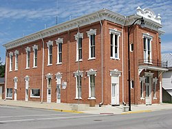
Brown Township Building, Ansonia.jpg
Brown Township Building in downtown Ansonia
Darke County Ohio incorporated and unincorporated areas Ansonia highlighted.svg
Location in Darke County and the state of Ohio.
Detailed map of Ansonia, Ohio.png
Detailed map of Ansonia
Coordinates: 40°12′49″N84°38′05″W / 40.21361°N 84.63472°W / 40.21361; -84.63472
Country United States
State Ohio
County Darke
Township Brown
Government
   Mayor Ted Adkins[ citation needed ]
  Public Works DirectorDon DeMange[ citation needed ]
   City Councilman Mike Hacker, John Middleton, Dan Brown[ citation needed ]
Area
[1]
  Total
0.67 sq mi (1.73 km2)
  Land0.65 sq mi (1.68 km2)
  Water0.02 sq mi (0.05 km2)
Elevation
[2]
1,001 ft (305 m)
Population
 (2020)
  Total
1,160
  Estimate 
(2023) [3]
1,149
  Density1,792.89/sq mi (691.83/km2)
Time zone UTC-5 (Eastern (EST))
  Summer (DST) UTC-4 (EDT)
ZIP code
45303
Area codes 937, 326
FIPS code 39-02120 [4]
GNIS feature ID2397968 [2]
Website Village website

Ansonia is a village in Darke County, Ohio, United States. The population was 1,160 at the 2020 census.

Contents

History

Ansonia was founded in 1845 under the name of "Dallas." The village initially grew slowly; significant expansion only came after the coming of a railroad in 1852. [5] :568 Because dense swamps hindered settlement in the vicinity, [5] :566 woodland was plentiful, and Ansonia became a center of manufacturing for hardwood products. [5] :568 In 1873, the residents replaced their old school with a substantial two-story building at the cost of ten thousand dollars; this building was the first home of Ansonia High School, which was founded in that year. In turn, this building was demolished and a replacement erected in 1903. Another prominent structure in the village was a mausoleum; built of marble in 1911, it was the first mausoleum in Darke County. [5] :569

In its early decades, Ansonia was heavily influenced by Freemasonry. The community's first lodge was chartered on October 21, 1874, with a membership of sixteen; in its first forty years, this lodge expanded nearly eightfold. An IOOF lodge was instituted on June 18, 1875, with sixteen members; it grew nearly sevenfold in its first forty years. Sixteen women in the community founded a chapter of the Daughters of Rebekah in 1894, and a lodge of the Knights of Pythias was also established in the village in 1889. [5] :569 [6]

Geography

According to the United States Census Bureau, the village has a total area of 0.81 square miles (2.10 km2), of which 0.79 square miles (2.05 km2) is land and 0.02 square miles (0.05 km2) is water. [7] It is approximately six miles north of the county seat of Greenville.

Demographics

Historical population
CensusPop.Note
1880 542
1890 67624.7%
1900 6760.0%
1910 656−3.0%
1920 80723.0%
1930 651−19.3%
1940 7129.4%
1950 87723.2%
1960 1,00214.3%
1970 1,0444.2%
1980 1,26721.4%
1990 1,2790.9%
2000 1,145−10.5%
2010 1,1742.5%
2020 1,160−1.2%
2023 (est.)1,149 [3] −0.9%
U.S. Decennial Census [8]

2010 census

As of the census [9] of 2010, there were 1,174 people, 448 households, and 322 families living in the village. The population density was 1,486.1 inhabitants per square mile (573.8/km2). There were 500 housing units at an average density of 632.9 per square mile (244.4/km2). The racial makeup of the village was 98.8% White, 0.3% Native American, 0.2% Asian, 0.2% from other races, and 0.6% from two or more races. Hispanic or Latino of any race were 1.6% of the population.

There were 448 households, of which 37.5% had children under the age of 18 living with them, 50.0% were married couples living together, 14.5% had a female householder with no husband present, 7.4% had a male householder with no wife present, and 28.1% were non-families. 21.9% of all households were made up of individuals, and 9.6% had someone living alone who was 65 years of age or older. The average household size was 2.62, and the average family size was 3.02.

The median age in the village was 35.4 years. 27.6% of residents were under the age of 18; 9.3% were between the ages of 18 and 24; 25.1% were from 25 to 44; 27.5% were from 45 to 64, and 10.3% were 65 years of age or older. The gender makeup of the village was 48.5% male and 51.5% female.

2000 census

As of the census [4] of 2000, there were 1,145 people, 451 households, and 331 families living in the village. The population density was 1,717.0 inhabitants per square mile (662.9/km2). There were 479 housing units at an average density of 718.3 per square mile (277.3/km2). The racial makeup of the village was 99.13% White, 0.26% Native American, 0.52% from other races, and 0.09% from two or more races. Hispanic or Latino of any race were 1.40% of the population.

There were 451 households, out of which 35.3% had children under the age of 18 living with them, 55.9% were married couples living together, 11.1% had a female householder with no husband present, and 26.6% were non-families. 23.3% of all households were made up of individuals, and 10.0% had someone living alone who was 65 years of age or older. The average household size was 2.54, and the average family size was 2.99.

In the village, the population was spread out, with 27.7% under the age of 18, 8.6% from 18 to 24, 30.0% from 25 to 44, 21.3% from 45 to 64, and 12.5% who were 65 years of age or older. The median age was 34 years. For every 100 females, there were 97.8 males. For every 100 females age 18 and over, there were 100.5 males.

The median income for a household in the village was $35,882, and the median income for a family was $38,529. Males had a median income of $28,452 versus $22,460 for females. The per capita income for the village was $16,633. About 4.2% of families and 7.0% of the population were below the poverty line, including 12.7% of those under age 18 and 1.7% of those age 65 or over.
Related Research Articles

<span class="mw-page-title-main">Darke County, Ohio</span> County in Ohio, United States

Darke County is a county in the U.S. state of Ohio. As of the 2020 census, the population was 51,881. Its county seat and largest city is Greenville. The county was created in 1809 and later organized in 1817. It is named for William Darke, an officer in the American Revolutionary War. Darke County comprises the Greenville, OH Micropolitan Statistical Area, which is also included in the Dayton-Springfield-Sidney, OH Combined Statistical Area.

<span class="mw-page-title-main">Arcanum, Ohio</span> Village in Ohio, United States

Arcanum is a village in Darke County, Ohio, United States. The population was 2,457 at the 2020 census.

<span class="mw-page-title-main">Castine, Ohio</span> Village in Ohio, United States

Castine is a village in Darke County, Ohio, United States. The population was 110 at the 2020 census.

<span class="mw-page-title-main">Gettysburg, Ohio</span> Village in Ohio, United States

Gettysburg is a village in Darke County, Ohio, United States. The population was 463 at the 2020 census.

<span class="mw-page-title-main">Gordon, Ohio</span> Village in Ohio, United States

Gordon is a village in Darke County, Ohio, United States. The population was 245 at the 2020 census.

<span class="mw-page-title-main">Hollansburg, Ohio</span> Village in Ohio, United States

Hollansburg is a village in Darke County, Ohio, United States. The population was 243 at the 2020 census.

<span class="mw-page-title-main">Ithaca, Ohio</span> Village in Ohio, United States

Ithaca is a village in Darke County, Ohio, United States. The population was 81 at the 2020 census.

<span class="mw-page-title-main">New Madison, Ohio</span> Village in Ohio, United States

New Madison is a village in Darke County, Ohio, United States. The population was 840 at the 2020 census.

<span class="mw-page-title-main">New Weston, Ohio</span> Village in Ohio, United States

New Weston is a village in Darke County, Ohio, United States. The population was 124 at the 2020 census.

<span class="mw-page-title-main">North Star, Ohio</span> Village in Ohio, United States

North Star is a village in Darke County, Ohio, United States. The population was 224 at the 2020 census.

<span class="mw-page-title-main">Osgood, Ohio</span> Village in Ohio, United States

Osgood is a village in Darke County, Ohio, United States. The population was 306 at the 2020 census.

<span class="mw-page-title-main">Palestine, Ohio</span> Village in Ohio, United States

Palestine is a village in Darke County, Ohio, United States. The population was 180 at the 2020 census.

<span class="mw-page-title-main">Pitsburg, Ohio</span> Village in Ohio, United States

Pitsburg is a village in Monroe Township, Darke County, Ohio, United States. The population was 381 at the 2020 census.

<span class="mw-page-title-main">Rossburg, Ohio</span> Village in Ohio, United States

Rossburg is a village in Darke County, Ohio, United States. The population was 159 at the 2020 census.

<span class="mw-page-title-main">Union City, Ohio</span> Village in Ohio, United States

Union City is a village in Darke County, Ohio, United States. The population was 1,582 at the 2020 census. It is directly across the state line from its twin city of Union City, Indiana.

<span class="mw-page-title-main">Versailles, Ohio</span> Village in Ohio, United States

Versailles is a village in Darke County, Ohio, United States. It is the only village in Wayne Township. The population was 2,692 at the 2020 census.

<span class="mw-page-title-main">Wayne Lakes, Ohio</span> Village in Ohio, United States

Wayne Lakes is a village in Darke County, Ohio, United States. The population was 693 at the 2020 census.

<span class="mw-page-title-main">Yorkshire, Ohio</span> Village in Ohio, United States

Yorkshire is a village in Darke County, Ohio, United States. The population was 95 at the 2020 census.

<span class="mw-page-title-main">Bradford, Ohio</span> Village in Ohio, United States

Bradford is a village in Darke and Miami counties in the U.S. state of Ohio. The population was 1,796 at the 2020 census.

<span class="mw-page-title-main">Burkettsville, Ohio</span> Village in Ohio, United States

Burkettsville is a village in Darke and Mercer counties in the U.S. state of Ohio. The population was 272 at the 2020 census.

References

  1. "ArcGIS REST Services Directory". United States Census Bureau. Retrieved September 20, 2022.
  2. 1 2 U.S. Geological Survey Geographic Names Information System: Ansonia, Ohio
  3. 1 2 "Annual Estimates of the Resident Population for Incorporated Places in Ohio: April 1, 2020 to July 1, 2023". United States Census Bureau. Retrieved May 20, 2024.
  4. 1 2 "U.S. Census website". United States Census Bureau . Retrieved January 31, 2008.
  5. 1 2 3 4 5 Wilson, Frazer Ells (1914). History of Darke County, Ohio, from its earliest settlement to the present time, Vol. 1. Milford, Ohio: Hobart Publishing Company.
  6. Ansonia Mirror newspaper transcriptions in the Garst Museum, Greenville
  7. "US Gazetteer files 2010". United States Census Bureau. Archived from the original on January 25, 2012. Retrieved January 6, 2013.
  8. "Census of Population and Housing". Census.gov. Retrieved June 4, 2015.
  9. "U.S. Census website". United States Census Bureau . Retrieved January 6, 2013.