Osgood, Ohio

Last updated

Osgood, Ohio
Osgood, Ohio.jpg
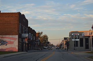
Main Street in Osgood
Darke County Ohio incorporated and unincorporated areas Osgood highlighted.svg
Location in Darke County and the state of Ohio
Coordinates: 40°20′24″N84°29′46″W / 40.34000°N 84.49611°W / 40.34000; -84.49611
Country United States
State Ohio
County Darke
Township Patterson
Area
[1]
  Total0.35 sq mi (0.91 km2)
  Land0.35 sq mi (0.91 km2)
  Water0.00 sq mi (0.00 km2)
Elevation
[2]
961 ft (293 m)
Population
 (2020)
  Total306
  Density869.32/sq mi (335.64/km2)
Time zone UTC-5 (Eastern (EST))
  Summer (DST) UTC-4 (EDT)
ZIP code
45351
Area code 419
FIPS code 39-58912 [3]
GNIS feature ID1044204 [2]

Osgood is a village in Darke County, Ohio, United States. The population was 306 at the 2020 census.

Contents

History

Osgood was founded in the 1880s. [4] While its earliest settlers were primarily Protestants, [5] a Roman Catholic parish was erected in the village in 1906. [4] Today, St. Nicholas' Catholic Church has been recognized as a historic site. [6]

Geography

Osgood is located at 40°20′24″N84°29′46″W / 40.34000°N 84.49611°W / 40.34000; -84.49611 (40.340133, -84.495983). [7]

According to the United States Census Bureau, the village has a total area of 0.34 square miles (0.88 km2), all land. [8]

Demographics

Historical population
CensusPop.Note
1890 242
1900 224−7.4%
1910 214−4.5%
1920 175−18.2%
1930 152−13.1%
1940 17917.8%
1950 1948.4%
1960 24124.2%
1970 28919.9%
1980 3065.9%
1990 255−16.7%
2000 2550.0%
2010 30218.4%
2020 3061.3%
U.S. Decennial Census [9]

2010 census

As of the census [10] of 2010, there were 302 people, 120 households, and 82 families living in the village. The population density was 888.2 inhabitants per square mile (342.9/km2). There were 121 housing units at an average density of 355.9 per square mile (137.4/km2). The racial makeup of the village was 98.3% White and 1.7% Native American. Hispanic or Latino of any race were 1.3% of the population.

There were 120 households, of which 30.0% had children under the age of 18 living with them, 60.8% were married couples living together, 6.7% had a female householder with no husband present, 0.8% had a male householder with no wife present, and 31.7% were non-families. 29.2% of all households were made up of individuals, and 20% had someone living alone who was 65 years of age or older. The average household size was 2.52 and the average family size was 3.17.

The median age in the village was 38.4 years. 28.5% of residents were under the age of 18; 5.6% were between the ages of 18 and 24; 26.1% were from 25 to 44; 17.5% were from 45 to 64; and 22.2% were 65 years of age or older. The gender makeup of the village was 52.6% male and 47.4% female.

2000 census

As of the census [3] of 2000, there were 255 people, 103 households, and 77 families living in the village. The population density was 742.1 inhabitants per square mile (286.5/km2). There were 104 housing units at an average density of 302.7 per square mile (116.9/km2). The racial makeup of the village was 100.00% White.

There were 103 households, out of which 25.2% had children under the age of 18 living with them, 64.1% were married couples living together, 5.8% had a female householder with no husband present, and 25.2% were non-families. 24.3% of all households were made up of individuals, and 19.4% had someone living alone who was 65 years of age or older. The average household size was 2.48 and the average family size was 2.92.

In the village, the population was spread out, with 23.5% under the age of 18, 5.1% from 18 to 24, 27.8% from 25 to 44, 20.8% from 45 to 64, and 22.7% who were 65 years of age or older. The median age was 38 years. For every 100 females, there were 96.2 males. For every 100 females age 18 and over, there were 91.2 males.

The median income for a household in the village was $41,731, and the median income for a family was $48,125. Males had a median income of $37,875 versus $24,375 for females. The per capita income for the village was $18,686. None of the families and 0.4% of the population were living below the poverty line.

Related Research Articles

<span class="mw-page-title-main">Pomona Park, Florida</span> Town in the state of Florida, United States

Pomona Park is a town in Putnam County, Florida, United States. The population was 912 at the 2010 census and has gone up to 916 in the 2018 estimates. The town is part of the Palatka Micropolitan Statistical Area.

<span class="mw-page-title-main">Vergennes, Illinois</span> Village in Illinois, United States

Vergennes is a village in Jackson County, Illinois, United States. The population was 298 at the 2010 census, down from 491 at the 2000 census.

<span class="mw-page-title-main">Exeter, Illinois</span> Village in Illinois, United States

Exeter is a village in Scott County, Illinois, United States. The population was 70 at the 2000 census. It is part of the Jacksonville Micropolitan Statistical Area.

<span class="mw-page-title-main">Osgood, Missouri</span> Village in Missouri, United States

Osgood is a village in western Sullivan County, Missouri, United States. The population was 24 at the 2020 census.

<span class="mw-page-title-main">Midland, Ohio</span> Village in Ohio, United States

Midland is a village in Clinton County, Ohio, United States. The population was 307 at the 2020 census.

<span class="mw-page-title-main">Gordon, Ohio</span> Village in Ohio, United States

Gordon is a village in Darke County, Ohio, United States. The population was 245 at the 2020 census.

<span class="mw-page-title-main">Greenville, Ohio</span> City in Ohio, United States

Greenville is a city in and the county seat of Darke County, Ohio, United States. It is located near Ohio's western edge, about 33 miles (53 km) northwest of Dayton. The population was 12,786 at the 2020 census.

<span class="mw-page-title-main">Ithaca, Ohio</span> Village in Ohio, United States

Ithaca is a village in Darke County, Ohio, United States. The population was 81 at the 2020 census.

<span class="mw-page-title-main">New Weston, Ohio</span> Village in Ohio, United States

New Weston is a village in Darke County, Ohio, United States. The population was 124 at the 2020 census.

<span class="mw-page-title-main">Palestine, Ohio</span> Village in Ohio, United States

Palestine is a village in Darke County, Ohio, United States. The population was 180 at the 2020 census.

<span class="mw-page-title-main">Pleasant City, Ohio</span> Village in Ohio, United States

Pleasant City is a village in Guernsey County, Ohio, United States. The population was 400 at the 2020 census.

<span class="mw-page-title-main">Addyston, Ohio</span> Village in Ohio, United States

Addyston is a village in Miami Township, Hamilton County, Ohio, United States, along the Ohio River. The population was 927 at the 2020 census.

<span class="mw-page-title-main">Mowrystown, Ohio</span> Village in Ohio, United States

Mowrystown is a village in Highland County, Ohio, United States. The population was 385 at the 2020 census.

<span class="mw-page-title-main">Hanover, Ohio</span> Village in Ohio, United States

Hanover is a village in Licking County, Ohio, United States. The population was 1,270 at the 2020 census. The village lies along Ohio State Route 16.

<span class="mw-page-title-main">Miltonsburg, Ohio</span> Village in Ohio, United States

Miltonsburg is a village in Monroe County, Ohio, United States. The population was 42 at the 2020 census. Miltonsburg was named after Milton Pierson, son of Ohio pioneer David Pierson. David Pierson named Clarington, Ohio after his daughter Clarinda.

<span class="mw-page-title-main">Adamsville, Ohio</span> Village in Ohio, United States

Adamsville is a village in Muskingum County, Ohio, United States. The population was 140 at the 2020 census. It is part of the Zanesville micropolitan area.

<span class="mw-page-title-main">Beech Bottom, West Virginia</span> Village in West Virginia, United States

Beech Bottom is a village in Brooke County, West Virginia, United States, situated along the Ohio River. The population was 523 at the 2010 census. It is part of the Weirton–Steubenville metropolitan area.

<span class="mw-page-title-main">Wilson, Ohio</span> Village in Ohio, United States

Wilson is a village in Belmont and Monroe counties in the U.S. state of Ohio. The population was 129 at the 2020 census. It is part of the Wheeling metropolitan area.

<span class="mw-page-title-main">Burkettsville, Ohio</span> Village in Ohio, United States

Burkettsville is a village in Darke and Mercer counties in the U.S. state of Ohio. The population was 272 at the 2020 census.

Spencer is a village located in the Town of Spencer in Tioga County, New York, United States. The population was 759 at the 2010 census. It is part of the Binghamton Metropolitan Statistical Area. The town and village are named after Judge Ambrose Spencer.

References

  1. "ArcGIS REST Services Directory". United States Census Bureau. Retrieved September 20, 2022.
  2. 1 2 "US Board on Geographic Names". United States Geological Survey. October 25, 2007. Retrieved January 31, 2008.
  3. 1 2 "U.S. Census website". United States Census Bureau . Retrieved January 31, 2008.
  4. 1 2 Wilson, Frazer Ells (1914). History of Darke County, Ohio, from its earliest settlement to the present time, Vol. 1. Milford, Ohio: Hobart Publishing Company. p. 602.
  5. Brown, Mary Ann. Ohio Historic Inventory Nomination: St. Louis Catholic Church. Ohio Historical Society, August 1977.
  6. "National Register Information System". National Register of Historic Places . National Park Service. March 13, 2009.
  7. "US Gazetteer files: 2010, 2000, and 1990". United States Census Bureau. February 12, 2011. Retrieved April 23, 2011.
  8. "US Gazetteer files 2010". United States Census Bureau. Archived from the original on January 25, 2012. Retrieved January 6, 2013.
  9. "Census of Population and Housing". Census.gov. Retrieved June 4, 2015.
  10. "U.S. Census website". United States Census Bureau . Retrieved January 6, 2013.