U.S. Route 224 (US 224) is a spur of US 24 that runs through the states of Indiana, Ohio and Pennsylvania. It currently runs for 289 miles (465 km) from Huntington, Indiana. at US 24 to New Castle, Pennsylvania, at US 422 Business and Pennsylvania Route 18 (PA 18). It goes through the cities of Canfield, Ohio, Akron, Ohio, and Findlay, Ohio. In Northeast Ohio, US 224 is located a short distance north of the Western Reserve's southern boundary.
State Route 55 (SR 55) is an east–west state route in western Ohio. Its western terminus is near the town of Laura at SR 571, and its eastern terminus is south of downtown Urbana at U.S. Route 68 (US 68).
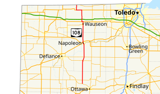
State Route 108 (SR 108) is a 49.30-mile (79.34 km) state route that runs between SR 15 and the Michigan state line in the US state of Ohio. Most of the route is a rural two-lane highway and passes through both farmland and residential properties.

State Route 34 (SR 34) is an Ohio State Route that runs between Indiana State Road 427, west of Edon and US 6 (US 6) in the US state of Ohio. The 32.02 miles (51.53 km) of SR 34 that lie within the state serve as a minor highway. None of the highway is listed on the National Highway System. Various sections are rural two-lane highway and urban four-lane highway. The highway passes through residential and commercial properties.

State Route 745 (SR 745) is a state route in central Ohio that runs in a north-northwesterly direction along the west bank of the Scioto River. Its southern terminus is at the concurrency of U.S. Route 33 (US 33) and SR 161 in Dublin, and it runs for approximately ten miles (16 km) to Concord Township in Delaware County, where it arrives at its northern terminus at the concurrency of US 42 and SR 257. SR 745 was designated in 1937, and its routing has not changed since.

State Route 515 is a north-south state highway located in east-central Ohio. Existing entirely within the northeastern portion of Holmes County in Ohio's Amish Country, SR 515 has its southern terminus at a signalized intersection with SR 39 in the unincorporated community of Walnut Creek. Its northern terminus is at a T-intersection with U.S. Route 62 (US 62) one mile (1.6 km) southwest of the hamlet of Winesburg.

State Route 242 was an east–west state highway in the west-central portion of Ohio. The western terminus of the route was at U.S. Route 127 approximately 5 miles (8.0 km) north of Greenville. Its eastern terminus was at a T-intersection with SR 121 adjacent to Darke County Airport about 1.5 miles (2.4 km) southwest of Versailles.
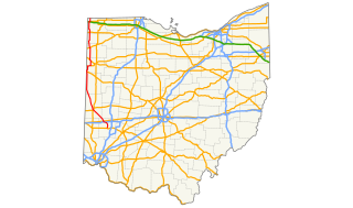
State Route 49 is a state highway in the western part of the U.S. state of Ohio. It begins in Drexel, an area within the city of Trotwood, at US 35 and runs northwesterly to Greenville, and then runs roughly along near the western edge of the state near the Indiana state line to the Michigan state line where it meets with Michigan's M-49.

State Route 109 (SR 109) is a 52.9-mile (85.1 km) state route that runs between Ottawa and the Michigan state line in the US state of Ohio. It crosses a major river, the Maumee, east of Napoleon. Most of the route is a rural two-lane highway and passes through both farmland and residential properties.

State Route 601 is a north–south state highway in North Central Ohio. A two-lane eastern bypass of Norwalk, SR 601 has its southern terminus at SR 18 southeast of Norwalk, adjacent to Summit Motorsports Park. The northern terminus of SR 601 is at SR 113 in downtown Milan, less than one-quarter mile (0.40 km) east of the junction of SR 113 and the U.S. Route 250 (US 250)/SR 13 concurrency.

State Route 500 (SR 500) is a 13.32-mile-long (21.44 km) Ohio State Route that runs between the Indiana state line and Paulding in the US state of Ohio. None of the highway is listed on the National Highway System. Most of the route is a rural two-lane highway and passes through both farmland and residential properties. For much of its path, SR 500 runs generally parallel to the north of Flatrock Creek.

State Route 709 is an east–west state route in western Ohio. SR 709 exists entirely in southern Van Wert County. Its western terminus is at SR 118 in Ohio City, and its eastern terminus is at SR 116 just south of Venedocia.

State Route 762 is an east–west state highway in central Ohio, a U.S. state. The highway has its western terminus at a signalized intersection with the concurrency of U.S. Route 62 and SR 3 just 0.25 miles (0.40 km) south of the village limits of Harrisburg. SR 762's eastern terminus is at an intersection of Pickaway County Route 385 near the Rickenbacker International Airport.
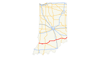
U.S. Route 50 (US 50) is a part of the United States Numbered Highway System that runs from West Sacramento, California, to Ocean City, Maryland. In the U.S. state of Indiana, it is part of the state road system. US 50 enters the state in Vincennes. The 171.38 miles (275.81 km) of US 50 that lie within Indiana serve as a major conduit. All of the highway is listed on the National Highway System. Various sections are rural two-lane highway, urbanized four-lane undivided highway and one-way streets. The easternmost community along the highway is Lawrenceburg at the Ohio state line. US 50 passes through urban areas, farmland and woodland.

Ohio State Route 118 (SR 118) is a 55.30-mile (89.00 km) long north–south state highway in western Ohio, connecting the cities of Greenville and Van Wert. SR 118 runs northward through Darke, Mercer and Van Wert counties, starting from a roundabout with SR 49, SR 571, SR 121 and SR 502 in Greenville. The route crosses through the farming villages of Ansonia, St. Henry, Rossburg and Ohio City as well as the villages of Coldwater and Rockford. Just north of Rossburg, SR 118 serves Eldora Speedway, a clay oval racetrack owned by NASCAR driver Tony Stewart. The northern terminus of SR 118 is at a junction with U.S. Route 127 in the city of Van Wert.

State Route 319 (SR 319) is a very short, two-lane state highway in the western portion of the U.S. state of Ohio. A spur route, SR 319 has its western terminus at an abandoned railroad grade just west of Washington Street in the village of Burkettsville. Its eastern terminus is 0.56 miles (0.90 km) to the east of its western terminus at its junction with SR 118. SR 319 was established in the early 1930s. It started out as a much longer highway, but earlier segments would become a part of SR 118 in the late 1930s.

State Route 111 (SR 111) is a 31.49-mile (50.68 km) state route that runs between the Indiana state line and Defiance in the US state of Ohio. Most of the route is a rural two-lane highway and passes through both farmland and residential properties. For some of its path, SR 111 runs generally parallel to the north of the Auglaize River.
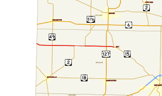
State Route 249 (SR 249) is an Ohio State Route that runs between the Indiana state line and Ney in the US state of Ohio. The 14.45 miles (23.26 km) of SR 249 that lie within the state serve as a minor highway. None of the highway is listed on the National Highway System. The whole route is a rural two-lane highway and passes through farmland. The highway was first signed in 1925 and was a north–south route, a route that later became U.S. Route 127 (US 127). SR 249 was given its current route in 1927, as a replacement for SR 22. The route was completely paved by 1942.

State Route 666 (SR 666) is a 14.17-mile (22.80 km) state route that runs between Zanesville and Dresden in the US state of Ohio. Most of the route is a rural two-lane highway and passes through both woodland and farmland. For much of its path, SR 666 runs generally parallel to the east of the Muskingum River. The highway was first signed in 1937 on the same alignment as today. The whole highway was paved by 1955.

State Route 634 (SR 634) is a 17.95-mile-long (28.89 km) state highway in the northwestern portion of the U.S. state of Ohio. The highway runs from its southern terminus at its junction with SR 189 and SR 190 in Fort Jennings to its northern terminus at the intersection of SR 15 nearly 1.5 miles (2.4 km) north of Continental. SR 634 runs entirely within Putnam County and is entirely a two-lane highway.


