Traffic circle

Last updated

Columbus Circle in New York City. Unlike a modern roundabout, the circle is quite large and pedestrians have access to the center island. Access is controlled by traffic lights. ColumbusCirclefromTimeWarnerCenterNYC20050807.jpg
Columbus Circle in New York City. Unlike a modern roundabout, the circle is quite large and pedestrians have access to the center island. Access is controlled by traffic lights.

A traffic circle is a type of intersection that directs both turning and through traffic onto a one-way circular roadway, usually built for the purposes of traffic calming or aesthetics. [1] Contrary to a roundabout, where entering traffic always yields to traffic already in the circle and merges in directly, the entrances to traffic circles are three-way intersections either controlled by stop signs, traffic signals, or not formally controlled. [2] Colloquially, however, roundabouts are sometimes referred to as circles. [3]

Roundabout Traffic intersection

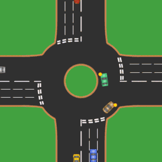
A roundabout is a type of circular intersection or junction in which road traffic is permitted to flow in one direction around a central island, and priority is given to traffic already on the junction.

Contents

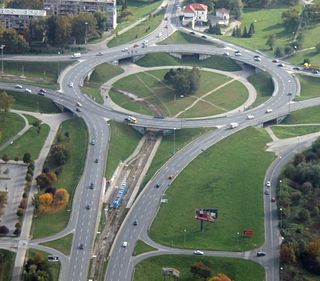
In the United States, traffic engineers typically use the term rotary for large scale circular junctions between expressways or controlled-access highways. Rotaries typically feature high speeds inside the circle and on the approaches. [4]

United States federal republic in North America

The United States of America (USA), commonly known as the United States or America, is a country composed of 50 states, a federal district, five major self-governing territories, and various possessions. At 3.8 million square miles, the United States is the world's third or fourth largest country by total area and is slightly smaller than the entire continent of Europe's 3.9 million square miles. With a population of over 327 million people, the U.S. is the third most populous country. The capital is Washington, D.C., and the largest city by population is New York City. Forty-eight states and the capital's federal district are contiguous in North America between Canada and Mexico. The State of Alaska is in the northwest corner of North America, bordered by Canada to the east and across the Bering Strait from Russia to the west. The State of Hawaii is an archipelago in the mid-Pacific Ocean. The U.S. territories are scattered about the Pacific Ocean and the Caribbean Sea, stretching across nine official time zones. The extremely diverse geography, climate, and wildlife of the United States make it one of the world's 17 megadiverse countries.

Limited-access road high-speed road with many characteristics of a controlled-access highway (freeway or motorway)

A limited-access road, known by various terms worldwide, including limited-access highway, dual-carriageway, expressway, and partial controlled access highway, is a highway or arterial road for high-speed traffic which has many or most characteristics of a controlled-access highway, including limited or no access to adjacent property, some degree of separation of opposing traffic flow, use of grade separated interchanges to some extent, prohibition of some modes of transport such as bicycles or horses, and very few or no intersecting cross-streets. The degree of isolation from local traffic allowed varies between countries and regions. The precise definition of these terms varies by jurisdiction.

Controlled-access highway Highway designed exclusively for high-speed vehicular traffic, with all traffic flow and ingress/egress regulated

A controlled-access highway is a type of highway which has been designed for high-speed vehicular traffic, with all traffic flow ingress- and egress-regulated. Common English terms are freeway, motorway and expressway. Other similar terms include Interstate and parkway. Some of these may be limited-access highways, although this term can also refer to a class of highway with somewhat less isolation from other traffic.

In New England, traffic circles are generally called rotaries and the traffic that is already driving in the rotary always has the right of way (see roundabout). For examples of where this is specified, in Massachusetts "Any operator of a vehicle entering a rotary intersection shall yield the right-of-way to any vehicle already in the intersection." [5] In Rhode Island entering vehicles "Yield to vehicles in the roundabout." [6]

New England Place

New England is a geographical region composed of six states of the northeastern United States: Maine, Vermont, New Hampshire, Massachusetts, Rhode Island, and Connecticut. It is bordered by the state of New York to the west and by the Canadian provinces of New Brunswick and Quebec to the northeast and north, respectively. The Atlantic Ocean is to the east and southeast, and Long Island Sound is to the south. Boston is New England's largest city as well as the capital of Massachusetts. The largest metropolitan area is Greater Boston with nearly a third of the entire region's population, which also includes Worcester, Massachusetts, Manchester, New Hampshire, and Providence, Rhode Island.

Massachusetts State of the United States of America

Massachusetts, officially the Commonwealth of Massachusetts, is the most populous state in the New England region of the northeastern United States. It borders on the Atlantic Ocean to the east, the states of Connecticut and Rhode Island to the south, New Hampshire and Vermont to the north, and New York to the west. The state is named after the Massachusett tribe, which once inhabited the east side of the area, and is one of the original thirteen states. The capital of Massachusetts is Boston, which is also the most populous city in New England. Over 80% of Massachusetts's population lives in the Greater Boston metropolitan area, a region influential upon American history, academia, and industry. Originally dependent on agriculture, fishing and trade, Massachusetts was transformed into a manufacturing center during the Industrial Revolution. During the 20th century, Massachusetts's economy shifted from manufacturing to services. Modern Massachusetts is a global leader in biotechnology, engineering, higher education, finance, and maritime trade.

Rhode Island State of the United States of America

Rhode Island, officially the State of Rhode Island and Providence Plantations, is a state in the New England region of the United States. It is the smallest state in area, the seventh least populous, and the second most densely populated, but it has the longest official name of any state. Rhode Island is bordered by Connecticut to the west, Massachusetts to the north and east, and the Atlantic Ocean to the south via Rhode Island Sound and Block Island Sound. It also shares a small maritime border with New York. Providence is the state capital and most populous city in Rhode Island.

Distinct from roundabouts, traffic circles and rotaries may also have an interior lane that requires traffic on it to change lanes in order to exit the circle. [7]

DeSoto Fountain sits in the center of a traffic circle in the City of Coral Gables, Florida. The arterial, DeSoto Boulevard, has unrestricted right of way, while the intersecting streets are controlled by stop signs. DeSoto Fountain in Coral Gables 20100321.jpg
DeSoto Fountain sits in the center of a traffic circle in the City of Coral Gables, Florida. The arterial, DeSoto Boulevard, has unrestricted right of way, while the intersecting streets are controlled by stop signs.

Design

Design criteria include:

New Jersey State of the United States of America

New Jersey is a state in the Mid-Atlantic region of the Northeastern United States. It is a peninsula, bordered on the north and east by the state of New York, particularly along the extent of the length of New York City on its western edge; on the east, southeast, and south by the Atlantic Ocean; on the west by the Delaware River and Pennsylvania; and on the southwest by the Delaware Bay and Delaware. New Jersey is the fourth-smallest state by area but the 11th-most populous, with 9 million residents as of 2017, and the most densely populated of the 50 U.S. states; its biggest city is Newark. New Jersey lies completely within the combined statistical areas of New York City and Philadelphia and was the second-wealthiest U.S. state by median household income as of 2017.

Washington, D.C. Capital of the United States

Washington, D.C., formally the District of Columbia and commonly referred to as Washington or D.C., is the capital of the United States. Founded after the American Revolution as the seat of government of the newly independent country, Washington was named after George Washington, first President of the United States and Founding Father. As the seat of the United States federal government and several international organizations, Washington is an important world political capital. The city is also one of the most visited cities in the world, with more than 20 million tourists annually.

Tangent straight line touching a point in a curve

In geometry, the tangent line to a plane curve at a given point is the straight line that "just touches" the curve at that point. Leibniz defined it as the line through a pair of infinitely close points on the curve. More precisely, a straight line is said to be a tangent of a curve y = f (x) at a point x = c on the curve if the line passes through the point (c, f ) on the curve and has slope f'(c) where f' is the derivative of f. A similar definition applies to space curves and curves in n-dimensional Euclidean space.

Traffic 10-abreast traverses the Place de l'Etoile . This traffic circle surrounds the Arc de Triomphe at the intersection of ten two-way and two one-way streets. It has no lane markings. Place Charles-de-Gaulle from the Arc de Triomphe, July 2001.jpg
Traffic 10-abreast traverses the Place de l'Étoile . This traffic circle surrounds the Arc de Triomphe at the intersection of ten two-way and two one-way streets. It has no lane markings.

History

French architect Eugène Hénard was designing one-way circular intersections as early as 1877. [14] American architect William Phelps Eno favored small traffic circles. He designed New York City's famous Columbus Circle, which was built in 1905. Other circular intersections were subsequently built in the United States, though many were large diameter 'rotaries' that enabled high speed merge and weave maneuvers. These designs were doomed to failure for two primary reasons:

Eugène Hénard French architect

Eugène Alfred Hénard was a French architect and a highly influential urban planner. He was a pioneer of roundabouts, which were first introduced in Paris in 1907.

William Phelps Eno American businessman

William Phelps Eno was an American businessman responsible for many of the earliest innovations in road safety and traffic control. He is sometimes known as the "Father of traffic safety", despite never having learned to drive a car himself.

Columbus Circle monument, circle and neighborhood in Manhattan, New York City

Columbus Circle is a traffic circle and heavily trafficked intersection in the New York City borough of Manhattan, located at the intersection of Eighth Avenue, Broadway, Central Park South, and Central Park West, at the southwest corner of Central Park. The circle is the point from which official highway distances from New York City are measured, as well as the center of the 25 miles (40 km) restricted-travel area for C-2 visa holders.

The experience with traffic circles and rotaries in the US was almost entirely negative,[ citation needed ] characterized by high accident rates and congestion problems. By the mid 1950s, construction of traffic circles and rotaries had ceased entirely. The experience with traffic circles in other countries was not much better until the development of the modern roundabout in the United Kingdom during the 1960s.

Starting in the 1990s the US saw a revival of mostly smaller traffic circles, termed "roundabouts". [15] The modern roundabout finally arrived in the United States in 1990 in Summerlin, a major Las Vegas residential subdivision. [15] As of December 2015 there are about 4800 of these modern roundabouts in the United States. As an example, Washington State contains about 120 roundabouts as of October 2016, all having been built since 1997 with more planned. [16]

See also

Related Research Articles

Traffic Road users travelling by foot or vehicle

Traffic on roads consists of road users including pedestrians, ridden or herded animals, vehicles, streetcars, buses and other conveyances, either singly or together, while using the public way for purposes of travel. Traffic laws are the laws which govern traffic and regulate vehicles, while rules of the road are both the laws and the informal rules that may have developed over time to facilitate the orderly and timely flow of traffic.

Intersection (road) A road junction where two or more roads either meet or cross at grade

An intersection is an at-grade junction where two or more roads meet or cross. Intersections may be classified by number of road segments, traffic controls, and/or lane design.

Three-way junction

A 3-way junction is a type of road intersection with three arms. A Y junction generally has 3 arms of equal size. A T junction also has 3 arms, but one of the arms is generally a minor road connecting to a larger road.

Traffic light signalling device to control competing flows of traffic

Traffic lights, also known as traffic signals, traffic lamps, traffic semaphore, signal lights, stop lights, robots, and traffic control signals, are signalling devices positioned at road intersections, pedestrian crossings, and other locations to control flows of traffic.

Stop sign traffic signal

A stop sign is a traffic sign designed to notify drivers that they must come to a complete stop and make sure no other road users are coming before proceeding.

Diamond interchange common type of road junction

A diamond interchange is a common type of road junction, used where a freeway crosses a minor road.

Superstreet

A superstreet, also known as a restricted crossing U-turn (RCUT), J-turn, or reduced conflict intersection, is a type of road intersection that is a variation of the Michigan left. In this configuration, in contrast to the Michigan left, traffic on the minor road is not permitted to proceed straight across the major road or highway. Drivers on the minor road wishing to turn left or go straight must turn right onto the major road, then, a short distance away, queue (wait) into a designated U-turn lane in the median. When traffic clears, they complete the U-turn and then either go straight or make a right turn when they intersect the other half of the minor road.

Right-in/right-out

Right-in/right-out (RIRO) and left-in/left-out (LILO) refer to a type of three-way road intersection where turning movements of vehicles are restricted. A RIRO permits only right turns and a LILO permits only left turns. "Right-in" and "left-in" refer to turns from a main road into an intersection ; "right-out" and "left-out" refer to turns from an intersection to a main road. RIRO is typical when vehicles drive on the right, and LILO is usual where vehicles drive on the left. This is because minor roads usually connect to the outsides of two-way roads. However, on a divided highway, both RIRO and LILO intersections can occur.

Yield sign yield or give way sign that indicates a driver must prepare to stop if necessary to let a driver on another approach proceed

In road transport, a yield or give way sign indicates that each driver must prepare to stop if necessary to let a driver on another approach proceed. A driver who stops or slows down to let another vehicle through has yielded the right of way to that vehicle. In contrast, a stop sign requires each driver to stop completely before proceeding, whether or not other traffic is present. Particular regulations regarding appearance, installation, and compliance with the signs vary by jurisdiction.

The Armdale Rotary is a roundabout in the Armdale district of Halifax, Nova Scotia.

Priority to the right is a right-of-way system, in which the driver of a vehicle is required to give way to vehicles approaching from the right at intersections. The system is stipulated in Article 18.4.a of the Vienna Convention on Road Traffic for countries where traffic keeps to the right and applies to all intersections where it is not overridden by priority signs, including side roads and roundabouts.

Bowtie (road)

The bowtie is a type of road intersection which replaces left turns or right turns, with roundabouts on the cross street. It is an alternative to the Michigan left intersection.

All-way stop intersection system

An all-way stop is an intersection system used predominantly in the United States of America, SADC, Liberia and Canada where traffic approaching it from all directions is required to stop before proceeding through the intersection. An all-way stop may have multiple approaches and may be marked with a supplemental plate stating the number of approaches.

Driving in the United States driving in the country of the United States

Driving in the United States is a frequent occurrence, with the majority of Americans using private automobiles as their primary form of transportation to their workplace. Each state has the authority to set its own traffic laws and issue driving licenses, although these laws are largely the same and licenses from other states are respected throughout the country. Americans drive on the right side of the road. There are numerous regulations on driving behavior, including speed limits, passing regulations, and seat belt requirements. Driving while intoxicated with alcohol is illegal in all jurisdictions within the U.S.

Road signs in Israel

Road signs in Israel are decided by the Ministry of Transportation in the Division of Transportation Planning, most recently set forth in June 2011.

Road signs in South Korea are regulated by the Korean Road Traffic Authority.

Cycling infrastructure

Cycling infrastructure refers to all infrastructure which may be used by cyclists. This includes the same network of roads and streets used by motorists, except those roads from which cyclists have been banned, plus additional bikeways that are not available to motor vehicles, such as bike paths, bike lanes, cycle tracks and, where permitted, sidewalks, plus amenities like bike racks for parking and specialized traffic signs and signals. Cycling modal share is strongly associated with the size of local cycling infrastructure.

Glossary of road transport terms Wikimedia list article

Terminology related to road transport—the transport of passengers or goods on paved routes between places—is diverse, with variation between dialects of English. There may also be regional differences within a single country, and some terms differ based on the side of the road traffic drives on. This glossary is an alphabetical listing of road transport terms.

References

  1. "Online TDM Encyclopedia - Traffic Calming". Vtpi.org. Retrieved 17 October 2018.
  2. "U.S. Department of Transportation: Roundabouts: an Informational Guide para 1.5" (PDF). Fhwa.dot.gov. Retrieved 17 October 2018.
  3. Johnson, Jeffrey A. (6 August 2012). "Salem Four Corners traffic circle to start rounding into shape". The Day .
  4. "Safety Aspects of Roundabouts - FHWA Safety Program". 3 September 2014. Archived from the original on 3 September 2014. Retrieved 17 October 2018.
  5. "General Law - Part I, Title XIV, Chapter 89, Section 8". malegislature.gov. Retrieved 17 October 2018.
  6. "Rhode Island Driver's Manual" (PDF). Dmv.ri.gov. Retrieved 17 October 2018.
  7. "Intersection Safety Roundabouts - Safety - Federal Highway Administration". Safety.fhwa.dot.gov. Retrieved 17 October 2018.
  8. "Archived copy". Archived from the original on 13 August 2010. Retrieved 2010-02-21.CS1 maint: Archived copy as title (link)
  9. "Archived copy" (PDF). Archived from the original (PDF) on 24 March 2012. Retrieved 22 November 2011.CS1 maint: Archived copy as title (link)
  10. Commonwealth of Massachusetts, Registry of Motor Vehicles. "Sharing the Road: A User's Manual for Public Ways" . Retrieved 2009-05-13.
  11. "Vehicle & Traffic Law - Right of Way". 3 July 2011. Archived from the original on 3 July 2011. Retrieved 17 October 2018.
  12. 1 2 3 "Index - Roundabout: An Informational Guide, June 2000 - FHWA-RD-00-067". Fhwa.dot.gov. Retrieved 17 October 2018.
  13. Shashi S. Nambisan, Venu Parimi (March 2007). "A Comparative Evaluation of the Safety Performance of Roundabouts and Traditional Intersection Controls". Institute of Transportation Engineers. Retrieved 2007-11-27.
  14. P. M. Wolf, Eugene Henard and the Beginning of Urbanism in Paris, 1900–1914, International Federation for Housing and Planning, The Hague, 1969, cited by Ben Hamilton-Baillie and Phil Jones, Improving traffic behaviour and safety through urban design, Proceedings of ICE – Civil Engineering, volume 158 Issue 5 May 2005 p. 41 "Archived copy" (PDF). Archived from the original (PDF) on 30 July 2007. Retrieved 2006-10-10.CS1 maint: Archived copy as title (link)
  15. 1 2
  16. "WSDOT - Washington's Roundabouts". 11 October 2016. Archived from the original on 11 October 2016. Retrieved 17 October 2018.