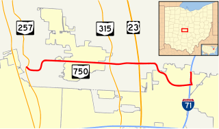
State Route 750 is an east–west state highway located in central Ohio. The western terminus of the state highway is at a signalized intersection with SR 257 nearly 2.5 miles (4.0 km) west of Powell, just outside the Columbus Zoo and Aquarium. The highway travels east to Highbanks Metro Park and Polaris Fashion Place. The eastern terminus of SR 750 is at Interstate 71 (I-71) in the far northern reaches of the city of Columbus. The route was designated in 1937, and both termini were rerouted. The eastern terminus was extended east in 1997, and the western terminus was rerouted south in 2007.
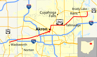
State Route 261 is an east–west state highway located in northeastern Ohio that passes through Medina, Summit, and Portage counties. At a length of 26 miles (42 km), SR 261 runs from a signalized intersection with SR 94 in Wadsworth to a signalized T-intersection with SR 59 in Franklin Township just east of Kent.
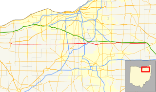
State Route 303 (SR 303) is a 75.71-mile-long (121.84 km) Ohio State Route that runs between Wakeman and Windham in the US state of Ohio. The highway is not listed on the National Highway System. Most of the route is a rural two-lane highway and passes through farmland, woodland, and residential properties. The route passes through the Cuyahoga Valley National Park. For some of its path, SR 303 runs generally parallel to the south of the Ohio Turnpike. SR 303 was first signed in 1932 on a section of the same alignment as today. The highway was extended towards the west in 1935. The highway was extended again in 1937. The eastern terminus was rerouted to its current intersection in the mid-1950s.
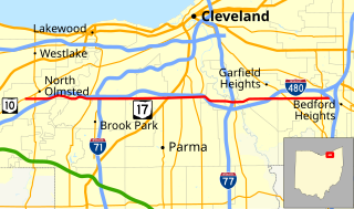
State Route 17 is an east–west highway in Northeast Ohio running from North Olmsted at State Route 10 to State Route 43 in Bedford Heights. The entire route has been paralleled by Interstate 480 and has junctions with this interstate via numerous cross streets such as Clague Road, Tiedeman Road, and Warrensville Center Road, and also via State Route 94 and State Route 14. It also has two direct junctions with the interstate. State Route 17 provides access to many industrial and commercial areas in this area of Cleveland.

State Route 327 (SR 327) is a north–south state highway in the south central portion of the U.S. state of Ohio. Its southern terminus is at U.S. Route 35 (US 35) about seven miles (11 km) southeast of Jackson, at a one-quadrant interchange. It ends at its northern terminus at SR 180 in Adelphi.

State Route 243 is an east–west state highway in the southern portion of the U.S. state of Ohio. The western terminus of SR 243 is at a diamond interchange with the U.S. Route 52 (US 52) in Coal Grove. The eastern terminus of the state highway is at its signalized junction with State Route 7 approximately 1.25 miles (2.01 km) west of Proctorville near the northern banks of the Ohio River.

State Route 173 (SR 173) is located in northeastern Ohio, and runs east–west from State Route 44, about 4 miles (6.4 km) north of Louisville, Ohio to State Route 14 and State Route 9 in downtown Salem, Ohio. It primarily passes through Stark and Columbiana counties, though it also straddles the county line between Mahoning County and Columbiana County for some of its length. Much of the route is also run in concurrency with U.S. Route 62.

State Route 167 is a 14.08-mile-long (22.66 km) east–west state highway in the northeastern portion of the U.S. state of Ohio. Its western terminus is at the northern end of the SR 46 and SR 307 concurrency in Jefferson, and its eastern terminus is at the Pennsylvania state line about 13 miles (21 km) south of Conneaut, where Pennsylvania Route 198 continues east. The route was designated in 1923, and has been rerouted three times since.

State Route 39 is a primarily east–west running state highway in north-central and northeastern portion of the U.S. state of Ohio. The route runs through seven counties on its approximately 155-mile (249 km) trip through the region. Its western terminus is at State Route 103 near New Washington, and its eastern terminus is at PA 68 near East Liverpool.
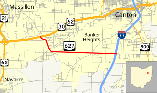
State Route 627 is an 4.76-mile (7.66 km) east–west state highway in Stark County, Ohio. SR 627's western terminus is at a diamond interchange with the US 30/US 62 freeway in southeast Massillon. Its eastern terminus is a diamond interchange with Interstate 77 at I-77 Exit 101 in southern Canton.
U.S. Route 50 runs east–west across the southern part of the U.S. state of Ohio, passing through Cincinnati, Chillicothe, and Athens. It is mainly a two-lane road except for the easternmost and westernmost parts. Near Athens it becomes part of State Route 32, a four-lane divided highway known as Corridor D, and from Reedsville to the Ohio/West Virginia border it also overlaps State Route 7 before crossing into Parkersburg, West Virginia.

State Route 364 (SR 364) is a north–south state route in Ohio. It starts from SR 705 near Yorkshire. The route moves north across several counties, then northeast against the side of the Grand Lake. SR 364 then travels west along a concurrency with SR 703, and ends at SR 29 near St. Marys. The route was designated in 1934, from SR 219 to SR 29. It was extended southwards to SR 705 in 1936 and completely paved by 1940. SR 364 was also extended in 1973 to the new alignment of SR 29.

State Route 165 is a 32-mile-long (51 km), primarily east–west running state route located in Mahoning and Columbiana counties in northeast Ohio. The route runs through generally rural sections of southern Mahoning County, and serves East Palestine in extreme northeast Columbiana County. The route connects quite a few unincorporated villages in southern Mahoning County as it passes through. The western terminus is at U.S. Route 62 and State Route 173 just south of Beloit, and the eastern terminus is at the Pennsylvania state line just to the east of East Palestine, where it becomes Taggart Road and heads toward Pennsylvania Route 51.

State Route 164 (SR 164) is a state highway passing through four counties in east-central Ohio. The route runs in a general southwest to northeast fashion, and is signed north–south accordingly. The southern terminus is at an intersection with State Route 212 1-mile (1.6 km) south of Leesville, and the northern terminus is at Interstate 680 and Western Reserve Road on the Beaver and Boardman township boundary between North Lima and Boardman. The southern part of the route serves more rural areas while it makes its way through larger villages and cities toward its northern end.
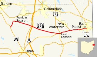
State Route 558 (SR 558) is a 15.74-mile (25.33 km) state route that runs between Salem and East Palestine in the US state of Ohio. Most of the route is a rural two-lane highway and passes through farmland, woodland and residential properties.

State Route 236 is a two-lane north–south state highway in the northeastern portion of the U.S. state of Ohio. Its southern terminus is at a signalized intersection with State Route 21 in the northern end of Massillon. The northern terminus of the route is at a Y-intersection with State Route 93 in New Franklin. The route follows part of the Ohio & Erie Canal Towpath.
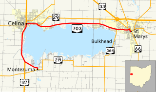
State Route 703 (SR 703) is a state highway in western Ohio. Its western terminus is in Montezuma at SR 219, and its eastern terminus is in St. Marys at an intersection with SR 29, SR 66, and the southern terminus of SR 116 in St. Marys. The route is mainly an east–west highway along the shores of Grand Lake St. Marys, although the section between Celina and Montezuma travels in a more north-south fashion.

State Route 295 is a north–south state highway in northwestern Ohio, a U.S. state. Its southern terminus is an intersection with SR 65 in Grand Rapids. Its northern terminus is at the Michigan State Line in Berkey. The roadway continues into Michigan as county-maintained Silberhorn Highway.

State Route 219 is an east–west state highway in the western portion of the U.S. state of Ohio. State Route 219's western terminus is at the Indiana State Line approximately 5.5 miles (8.9 km) northwest of Fort Recovery, with the roadway continuing west into the Hoosier State being County Road 300N. The eastern terminus of State Route 219 is at a diamond interchange with Interstate 75 at its Exit 104 in Botkins.

