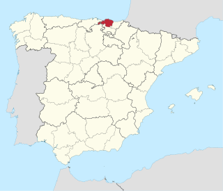
Biscay or Bizkaia, is a province of the Basque Autonomous Community, heir of the ancient Lordship of Biscay, lying on the south shore of the eponymous bay. The capital and largest city is Bilbao.

Ziortza-Bolibar is a municipality in the province of Biscay, Basque Country (Spain), in the comarca of Lea-Artibai. It has 383 inhabitants according to the 2006 census, and has an area of 18.94 km2.
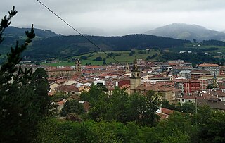
Durango is a town and municipality of the historical territory and province of Biscay, located in the Basque Country, Spain. It is the main town of Durangaldea, one of the comarcas of Biscay. Because of its economical activities and population, Durango is considered one of the largest towns in Biscay after the ones that compose the conurbation of Greater Bilbao.

Aulesti is a town and municipality located in the province of Biscay, in the autonomous community of the Basque Country in northern Spain. Aulesti is located in the region of Lea-Artibai, 44 kilometres (27 mi) from Bilbao, the capital of Biscay.

Markina-Xemein is a town and municipality located in the province of Biscay, Bizkaia, in the Basque Autonomous Community, also known as the Basque Country, located in northern Spain. The origin of the town's name lies in its geographic location. The last town in the province of Bizkaia, Markina-Xemein lies between Gipuzkoa and Bizkaia. Coming from the Spanish word "marca" meaning "mark", Markina-Xemein marks the location where the Gipuzkoanos often battled the Bizkainos.

Mundaka is a town and municipality located in the province of Biscay, in the autonomous community of Basque Country, in northern Spain. Mundaka is internationally renowned for the surfing community that takes advantage of its coast and unique oceanic conditions.

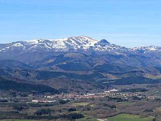
Anboto is a limestone mountain of the Western Basque Country, the highest peak of the Urkiola range and not far from the Urkiola mountain pass between Durango and Vitoria-Gasteiz.
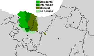
Biscayan, sometimes Bizkaian, is a dialect of the Basque language spoken mainly in Biscay, one of the provinces of the Basque Country of Spain.
Gorbea or Gorbeia is a mountain and massif in the Basque Country, Spain. It is the highest summit in Biscay and Álava, with a height of 1,482 metres (4,862 ft) above sea level. The massif covers a wide area between the two provinces. The main summit is a round grass-covered mountain crowned by a 17-metre-tall metallic cross. Historically, it was one of the five montes bocineros of Biscay, from where meetings to the Juntas Generales of the Lordship of Biscay were announced.
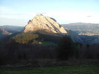
Urkiola is a mountain range of the Basque mountains in Biscay near Durango, in the western Basque Country, Spain. The highest mountain in the range is Anboto. The range runs from west to east and forms the water divide between the Atlantic and the Mediterranean basins.
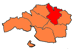
Busturialdea, also named Busturialde - Urdaibai is a comarca of the province of Biscay, in the Basque Country, Spain. It is the heir of "Busturia", one of the original merindades that used to compose the province of Biscay – this should not be confused with Busturia, a municipality located in this region. Busturialdea is a diminished portion of the same original subregion and has two capital cities; Bermeo and Gernika-Lumo. It is one of the seven comarcas that compose the province of Biscay.

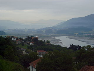
The Urdaibai estuary is a natural region and a Biosphere Reserve of Biscay, Basque Country, Spain. It is also referred as Mundaka or Gernika estuary.

Alluitz is a peak of Biscay, Basque Country (Spain), 1,034.3 metres high.

Untxillaitz, Untxillaitx, or Untzillatx, is a mountain of Biscay, Basque Country (Spain), 934 m. high. Its name may mean "Rabbit's peak".

The blowing horn or winding horn is a sound device that is usually made of or shaped like an animal horn, arranged to blow from a hole in the pointed end of it. This rudimentary device had a variety of functions in many cultures, in most cases reducing its scope to exhibiting, celebratory or group identification purposes. On the other hand, it has kept its function and profile in many cattle raising, agricultural and hunter-gatherer societies.

Iberia Flight 610 was a scheduled domestic passenger flight from Madrid to Bilbao, Basque Country, Spain. On 19 February 1985, a Boeing 727-200 operating the flight crashed into a ravine after one of its wings sliced a television antenna on the summit of Mount Oiz in Biscay during an approach to Bilbao Airport. All 141 passengers and 7 crew on board died. The crash is the deadliest aviation disaster in both the Basque Country and Iberia history.

The physical geography of the Basque Country is very diverse despite the small size of the region. The territory hosts a blend of green and brown to yellowish tones, featuring hilly terrain altogether. The Basque Country spreads from the rough coastal landscape to the semi-desert of the Bardenas on the south-eastern fringes of Navarre.
Tourism in the Basque Autonomous Community has increased considerably in recent years, and is a popular destination for tourists from Spain and France. According to data from the Eustat the number of tourists entering the region in the year 2009 was 1,991,790, with the final result still pending. 71% of the yearly visitors come from the rest of Spain; the greatest number from Madrid Autonomous Community (14.2%), and Catalonia (11.1%). International visitors make up the remaining 29% - the largest percent come from France (7.2%). 62% of the people who come to the Basque Autonomous Community visit one of the three capitals, 27% visit inland and 11% visit the coast. The average stay of the visitors is 2 days.
The Oca river is a river of the Cantabrian slope of the Iberian Peninsula that flows through the lands of Biscay, in the Basque Country (Spain).
Sollube is a mountain located in Bermeo, Biscay, in the Basque Country of Spain. It is situated on the left bank of the Urdaibai estuary, and constitutes one of the limits of the reserve. It extends across the municipalities of Bermeo, Meñaka, Arrieta and Busturia. The summit is located in Arrieta.


