Okakarara Constituency

Last updated
Okakarara Constituency (yellow) in the Otjozondjupa Region (dark grey) Wahlkreis Okakarara in Otjozondjupa.png
Okakarara Constituency (yellow) in the Otjozondjupa Region (dark grey)

Okakarara Constituency is an electoral constituency in the Otjozondjupa Region of Namibia. It has 21,336 inhabitants [1] and consists of the town of Okakarara and the surrounding rural area.

Constituencies of Namibia Wikimedia list article

Each of the 14 regions in Namibia is further subdivided into electoral constituencies. The size of the constituencies varies with the size and population of each region. There are currently 121 constituencies in Namibia. The most populous constituency is Walvis Bay Urban; the least populous is Walvis Bay Rural, both in the Erongo region.

Otjozondjupa Region Region in Namibia

Otjozondjupa region is one of the fourteen regions of Namibia, whose capital is Otjiwarongo. An outstanding landmark within this region is the Waterberg Plateau Park. Administration offices are based in Otjiwarongo which is the largest town in the region.

Namibia republic in southern Africa

Namibia, officially the Republic of Namibia, is a country in southern Africa. Its western border is the Atlantic Ocean; it shares land borders with Zambia and Angola to the north, Botswana to the east and South Africa to the south and east. Although it does not border Zimbabwe, less than 200 metres of the Zambezi River separates the two countries. Namibia gained independence from South Africa on 21 March 1990, following the Namibian War of Independence. Its capital and largest city is Windhoek, and it is a member state of the United Nations (UN), the Southern African Development Community (SADC), the African Union (AU), and the Commonwealth of Nations.

Politics

Okakarara is one of the few Namibian constituencies that are not dominated by the SWAPO Party. [2] The 2015 regional election was won by Vetaruhe Kandorozu of the National Unity Democratic Organisation (NUDO) with 3,628 votes, followed by Jonathan Tjakuva (SWAPO) with 2,126 votes and Abdal Mutjavikua of the Democratic Turnhalle Alliance (DTA) with 1,702 votes. Mujazu Urika of the South West Africa National Union (SWANU) also ran and gained 100 votes. [3]

The National Unity Democratic Organisation (NUDO) is a political party in Namibia. Esther Utjiua Muinjangue became the party’s first elected female president and the first elected female leader of a Namibian political party when she defeated the Okakarara constituency councillor, Vetaruhe Kandorozu, at the party’s third elective congress, which took place on 25-26 March 2019. At the elective congress, which was held in Windhoek, Peter Kazongominja was elected vice president and Joseph Kauandenge was elected secretary-general of the party. Muinjangue defeated the councillor by 240 to 227 votes. NUDO has been represented in the National Assembly of Namibia and in the National Council of Namibia since it split from the Democratic Turnhalle Alliance prior to the 2004 general and local elections.

Related Research Articles

Katima Mulilo Urban constituency of Namibia

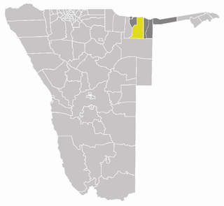
Katima Mulilo Urban is a constituency in the Zambezi Region of Namibia, covering the capital city of the region, Katima Mulilo. As of 2004, the Constituency had 10,778 registered voters.

Katima Mulilo Rural constituency of Namibia

Katima Mulilo Rural is a constituency in the Zambezi Region of Namibia. Its population is 22,197. It comprises the area south of the city of Katima Mulilo, the regional capital.

Keetmanshoop Urban constituency of Namibia

Keetmanshoop Urban is a constituency in the ǁKaras Region of Namibia. Its population is 14,945. It comprises the city of Keetmanshoop, except the Krönlein suburb.

Keetmanshoop Rural Electoral constituency of Namibia

Keetmanshoop Rural is an electoral constituency in the ǁKaras Region of Namibia. It contains the Krönlein suburb of Keetmanshoop and the villages of Koës and Aroab, the settlements of Seeheim and Klein Karas, as well as several farming communities in the area. The constituency office is situated in Aroab.

Oranjemund Constituency constituency of Namibia

Oranjemund is a constituency in the ǁKaras Region of Namibia. It covers an area of 27,000 km2 and has a population of 18,200 inhabitants. The main towns are the district capital Oranjemund and the mining town of Rosh Pinah, the constituency also contains the Sendelingsdrift border post.

Samora Machel Constituency constituency of Namibia

Samora Machel Constituency is a constituency in Windhoek in the Khomas Region of central Namibia. The constituency is located across four northern suburbs of Windhoek: Wanaheda, Greenwell Matongo, Goreangab, and part of Havana. As of 2010 it had 32,000 inhabitants.

Khomasdal North is a constituency in Windhoek in the Khomas Region of Namibia. Its population is 26,621. The constituency consists of parts of the suburbs Khomasdal, Katutura, and Otjomuise.

Windhoek Rural constituency of Namibia

Windhoek Rural is a constituency in the Khomas Region of Namibia. Its district capital is the settlement of Groot Aub. As of 2010 its population was 20,212. This constituency contains all settlements in the Khomas Region that are outside the city of Windhoek, among them:

Okakarara Town in Otjozondjupa Region, Namibia

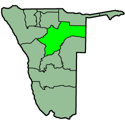
Okakarara is a town in Otjozondjupa Region, Namibia, located 50 kilometres (31 mi) southeast of Waterberg National Park. It has an estimated population of 7,000 and is currently growing by 1,500 inhabitants annually.

Kalahari Constituency

Kalahari Constituency is an electoral constituency in Omaheke Region, Namibia. It has 9,234 inhabitants, the constituency office has been inaugurated in 2009 and is located at the Ben-Hur settlement. The constituency forms part of the border between Namibia and Botswana.

Mashare Constituency

Mashare is a constituency in the Kavango East region of Namibia. It has 15,829 inhabitants, the district centre is the settlement of Mashare.

Engela is a constituency in the town of Helao Nafidi in the Ohangwena Region of northern Namibia. It has 21,341 inhabitants. It is home to one of the biggest hospitals in Namibia, Engela State Hospital.

Ongenga Constituency

Ongenga is a constituency in the Ohangwena Region of Namibia, on the border to Angola. It has 21,474 inhabitants, the district centre is the settlement of Ongenga.

Okalongo Constituency

Okalongo Constituency is an electoral constituency in the Omusati Region of Namibia on the border to Angola. It has 28,657 inhabitants. The constituency's capital is the settlement of Okalongo. It further contains villages such as: Onandjaba, Omatwadiva, Onaidjimba, Okafitu Kauvale, Olwiili, Ongolo, Ondudu, Onembaba, Ondobe Yehumba, Ondobe Yefidi, Ohakapeke, Olupandu, Epoko, Olupito, Onambome and many more.

Ruacana Constituency

Ruacana Constituency is an electoral constituency in the Omusati Region of Namibia on the border to Angola. It has 10,722 inhabitants, its district capital is the settlement of Ruacana.

Omatako Constituency

Omatako Constituency is an electoral constituency in the Otjozondjupa Region of Namibia. It has 11,998 inhabitants and contains the settlements of Kalkfeld, Hochfeld and Ovitoto, as well as the Osire refugee camp and the Osona military base.

Otavi Constituency

Otavi Constituency is an electoral constituency in the Otjozondjupa Region of Namibia. It has 11,620 inhabitants and consists of the town of Otavi and the surrounding rural area.

Otjiwarongo Constituency

Otjiwarongo Constituency is an electoral constituency in the Otjozondjupa Region of Namibia. It has 22,614 inhabitants and consists of the town of Otjiwarongo and the surrounding rural area.

Tsumkwe Constituency

Tsumkwe Constituency is an electoral constituency in the Otjozondjupa Region of Namibia. It has 8,823 inhabitants and consists of the settlement of Tsumkwe and the surrounding rural area.

References

Coordinates: 20°35′S17°26′E / 20.583°S 17.433°E / -20.583; 17.433

Geographic coordinate system Coordinate system

A geographic coordinate system is a coordinate system that enables every location on Earth to be specified by a set of numbers, letters or symbols. The coordinates are often chosen such that one of the numbers represents a vertical position and two or three of the numbers represent a horizontal position; alternatively, a geographic position may be expressed in a combined three-dimensional Cartesian vector. A common choice of coordinates is latitude, longitude and elevation. To specify a location on a plane requires a map projection.