The River Bollin is a major tributary of the River Mersey in the north-west of England.

The River Roch is a river in Greater Manchester in North West England, a tributary of the River Irwell, that gives Rochdale its name.

Shaw and Crompton is a town and civil parish within the Metropolitan Borough of Oldham, in Greater Manchester, England. It lies on the River Beal at the foothills of the South Pennines, 2.3 miles (3.7 km) north of Oldham, 3.6 miles (5.8 km) southeast of Rochdale, and 8.7 miles (14 km) to the northeast of the city of Manchester. It is regularly referred to as Shaw.

Hebble Brook is the body of water passing south from Ogden Reservoir, at Ogden, through Halifax and empties into the River Calder at Salterhebble.

The River Spodden is a watercourse in North West England, one of two major tributaries of the River Roch. It rises in the Lancashire South Pennine hills north of Whitworth and flows south through what is now known as the Whitworth Valley to Rochdale, Greater Manchester, where the river merges with the River Roch. Nestled within the picturesque wooded valley is Healey Dell Nature Reserve.
High Crompton is a locality in the west of the Shaw and Crompton parish of the Metropolitan Borough of Oldham, in Greater Manchester, England. It is formed around High Crompton Park and Rochdale Road.

The Beal is a small river in Greater Manchester, England, and is a tributary of the River Roch. It rises in the Beal Valley in green space between Sholver and Royton, before continuing northwards through Shaw and Crompton, Newhey, Milnrow and Belfield.

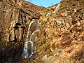
Black Brook in Lancashire has its source at Great Hill in the West Pennine Moors. The water is acidic due to a high level of peat in the uplands near to Round Loaf, giving the brook its brown colour. The young river was known as Warth Brook in olden Heapey. A feeder stream also known as Black Brook joins near Kittiwake Road - this short and weak water course commences at Eagle Tower. The jointed brook feeds Anglezarke Reservoir, and joins the River Yarrow in lowland Chorley at Yarrow Bridge. The entire course of Black Brook and the River Yarrow fall within Chorley and its villages.

Bradshaw Brook is a river draining parts of Lancashire and Greater Manchester in Northern England.

Crompton Moor is an area of moorland in the South Pennines, in North West England. It lies along the northeastern outskirts of Shaw and Crompton, in the Metropolitan Borough of Oldham, Greater Manchester.

Piethorne Brook is a watercourse in Greater Manchester. It is a tributary of the River Beal.

Brushes Clough Reservoir is on Crompton Moor in Shaw and Crompton, Greater Manchester, England. It was created in the 19th century by the damming of Leornardin Brook. The outlet of the reservoir flows through Brushes Clough to merge with Old Brook, a tributary of the River Beal.

Pencil Brook is a small watercourse in High Crompton in the Metropolitan Borough of Oldham, Greater Manchester, and is a tributary of the River Beal.

The Peak District Boundary Walk is a circular 190-mile (310 km) walking trail, starting and finishing at Buxton and broadly following the boundary of the Peak District, Britain's first national park. The route was developed by the Friends of the Peak District and was launched on 17 June 2017.