Old Town Hall, Droitwich Spa

Last updated

Old Town Hall, Droitwich Spa
The Old Town Hall (geograph 6710641).jpg
Old Town Hall, Droitwich Spa
LocationSt Andrews Street, Droitwich Spa
Coordinates 52°16′07″N2°08′56″W / 52.2685°N 2.1489°W / 52.2685; -2.1489 Coordinates: 52°16′07″N2°08′56″W / 52.2685°N 2.1489°W / 52.2685; -2.1489
Built1826
Architectural style(s) Neoclassical style
Listed Building – Grade II
Official nameTown Hall
Designated24 October 1951
Reference no.1095978
Worcestershire UK location map.svg
Red pog.svg
Shown in Worcestershire

The Old Town Hall is a municipal building in St Andrews Street, Droitwich Spa, Worcestershire, England. The structure, which was the headquarters of Droitwich Spa Borough Council, is a Grade II listed building. [1]

History

The first municipal building on the site was a medieval structure known as the Exchequer Building completed in 1327. [2] The building was used to regulate the salt trade, over which the crown had a near monopoly, [3] to collect the salt tax from people who had the right to extract salt and to deal with all aspects of the administration of the town. [2] The original structure was replaced by a more substantial timber-framed building in 1581. [4] The new Exchequer House featured some fine stained glass which was later removed and installed in St Andrew's Manor House. [4]

In the early 19th century, as part of measures to improve the Worcester to Bromsgrove Turnpike Road which passed along St Andrews Street, civic leaders decided to demolish the Exchequer Building and replace it with a new building slightly to the west of the original building. [5] The new building was designed in the neoclassical style, built in red brick with stucco facing and was completed in 1826. [1] It was arcaded on the ground floor so that markets could be held, with an assembly room on the first floor. [1] The design involved an asymmetrical main frontage with five bays facing onto St Andrews Street with the right hand bay curving round into Friar Street; the St Andrews Street elevation featured Doric order columns on the ground floor and round headed sash windows with moulded architraves on the first floor. [1] The original windows featured fine tracery [6] and there was a cornice and parapet at roof level. [1] The pillory and stocks were kept in front of the town hall. [7]

After significant population growth, largely associated with the salt industry, the area became a municipal borough with the town hall as its headquarters in 1835. [8] The town, which had previously been administered in accordance with a royal charter granted by King James I, had enjoyed extensive flexibility in the way it was managed; the new regime, which imposed a requirement for the council to be democratically elected, gave rise to some opposition and, in protest, the town clerk, initially transferred the town hall to his own name and refused to surrender the charter and other civic documents. [2] The building was extended with a further curve along Friar Street to a design by Henry Rowe in 1867. [9]

In the first part of the 20th century the local fire engine was kept in the arcaded area of the town hall, [5] but in 1940, during the Second World War, the area was partially infilled to create offices and, after the war, it was completely infilled. [10] The building continued to serve as the headquarters of the borough council for much of the 20th century but ceased to be local seat of government when the council moved to Norbury House in Friar Street in 1970. [10] The building was subsequently marketed for sale and then converted for retail use. [11]

Related Research Articles

Worcestershire County of England

Worcestershire is a county in the West Midlands of England. The area that is now Worcestershire was absorbed into the unified Kingdom of England in 927, at which time it was constituted as a county. Over the centuries the county borders have been modified, but it was not until 1844 that substantial changes were made. This culminated with the abolition of Worcestershire in 1974 with its northern area becoming part of the West Midlands and the rest part of the county of Hereford and Worcester. However, in 1998 the county of Hereford and Worcester was abolished and Worcestershire was reconstituted without the northern area, which was ceded to the West Midlands.

Kidderminster Human settlement in England

Kidderminster is a large market and historic minster town and civil parish in Worcestershire, England, 17 miles (27 km) south-west of Birmingham and 15 miles (24 km) north of Worcester. Located north of the River Stour and east of the River Severn, in the 2011 census, it had a population of 55,530. The town is twinned with Husum, Germany.
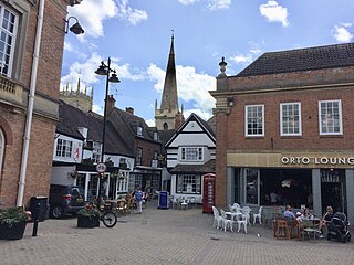
Droitwich Spa Human settlement in England

Droitwich Spa is an historic spa town in the Wychavon district in northern Worcestershire, England, on the River Salwarpe. It is located approximately 22 miles (35 km) south-west of Birmingham and 7 miles (11 km) north-east of Worcester.

Bromsgrove Human settlement in England

Bromsgrove is a town in Worcestershire, England, about 16 miles (26 km) north-east of Worcester and 13 miles (21 km) south-west of Birmingham city centre. It had a population of 29,237 in 2001. Bromsgrove is the main town in the larger Bromsgrove District. In the Middle Ages it was a small market town; primarily producing cloth through the early modern period. In the eighteenth and nineteenth centuries it became a major centre for nail making.

Redditch Borough in England

Redditch is a town, and local government district, in north-east Worcestershire, England, approximately 15 miles (24 km) south of Birmingham. The district has a population of 85,000 as of 2019. In the 19th century, it became the international centre for the needle and fishing tackle industry. At one point, 90% of the world's needles were manufactured in the town and its neighbourhoods. In the 1960s, it became a model for modern new town planning.

History of Worcestershire

The area now known as Worcestershire has had human presence for over half a million years. Interrupted by two ice ages, Worcestershire has had continuous settlement since roughly 10,000 years ago. In the Iron Age, the area was dominated by a series of hill forts, and the beginnings of industrial activity including pottery and salt mining can be found. It seems to have been relatively unimportant during the Roman era, with the exception of the salt workings.

Wychbold Human settlement in England

Wychbold is a village in the Wychavon district of Worcestershire. The village is situated on the A38 between Droitwich Spa and Bromsgrove, and by Junction 5 of the M5 motorway.

Droitwich Spa railway station Railway station in Worcestershire, England

Droitwich Spa railway station serves the town of Droitwich Spa in Worcestershire, England. It is located just to the south-west of Droitwich Spa Junction of the Worcester to Leamington Spa Line and the Worcester to Birmingham New Street line. The station is managed by West Midlands Trains, who also operate all trains serving it.

Droitwich Spa Junction is a railway junction located 250 metres north-east of Droitwich Spa railway station, in the town of Droitwich Spa, Worcestershire, England.

Dodderhill Human settlement in England

Dodderhill is a civil parish, near Droitwich, Worcestershire, England, located on the River Salwarpe. The parish is bisected by the M5 motorway, constructed in 1962. It is home to the Droitwich transmitting station in Wychbold.

Salwarpe Human settlement in England

Salwarpe is a small village and civil parish in the Wychavon district of Worcestershire, England, less than two miles south west of Droitwich, but in open country. The name is also spelled Salwarp, and in the time of John Leland was recorded as Salop. Since 2003, Salwarpe has shared a parish council with Hindlip and Martin Hussingtree.

Old Town Hall, Hemel Hempstead Municipal building in Hemel Hempstead, Hertfordshire, England

The Old Town Hall is a municipal building in the High Street, Hemel Hempstead, Hertfordshire, England. The town hall, which was the meeting place of Hemel Hempstead Borough Council, is a Grade II listed building.

Hastings Town Hall Municipal building in Hastings, East Sussex, England

Hastings Town Hall is a municipal building in Queen's Road, Hastings, East Sussex, England. The town hall, which was the meeting place of Hastings Borough Council, is a Grade II listed building.

Bridgwater Town Hall Municipal building in Bridgwater, Somerset, England

Bridgwater Town Hall is a municipal building in the High Street, Bridgwater, Somerset, England. The town hall, which was the headquarters of Bridgwater Borough Council, is a Grade II listed building.

Ballymena Town Hall Municipal Building in Ballymena, Northern Ireland

Ballymena Town Hall is a municipal structure in Bridge Street in Ballymena, County Antrim, Northern Ireland. The town hall, which is the headquarters of Mid and East Antrim Borough Council, is a Grade B1 listed building.

Evesham Town Hall Municipal building in Evesham, Worcestershire, England

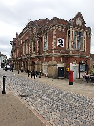
Evesham Town Hall is a municipal structure in the Market Place in Evesham, Worcestershire, England. The town hall, which was the headquarters of Evesham Borough Council, is a Grade II listed building.

Old Town Hall, Ellesmere Municipal building in Ellesmere, Shropshire, England

The Old Town Hall is a municipal building in the High Street in Ellesmere, Shropshire, England. The structure, which was the meeting place of Ellesmere Urban District Council, is a Grade II listed building.

Ripon Town Hall Municipal building in Ripon, North Yorkshire, England

Ripon Town Hall is a municipal building in the Market Place, Ripon, North Yorkshire, England. The structure, which was the headquarters of Ripon Borough Council, is a Grade II* listed building.

Rye Town Hall, East Sussex Municipal building in Rye, East Sussex, England

Rye Town Hall is a municipal building in Market Street, Rye, East Sussex, England. The building, which is the meeting place of Rye Town Council, is a Grade II* listed building.

References

  1. 1 2 3 4 5 Historic England. "Town Hall (1095978)". National Heritage List for England . Retrieved 13 July 2021.
  2. 1 2 3 "'The borough of Droitwich: Introduction and borough', in A History of the County of Worcester". London: British History Online. 1913. pp. 72–81. Retrieved 13 July 2021.
  3. "Droitwich ready to welcome King John for Charter Day bash". Bromsgrove Standard. 31 July 2015. Retrieved 13 July 2021.
  4. 1 2 Jones, Paul (1 April 2019). "A Peep in the Raven, and a study of its early stained glass" (PDF). Worcestershire Industrial Archaeology and Local History Society. Retrieved 13 July 2021.
  5. 1 2 Peberdy, Roger; Peberdy, Helen; Jones, Paul (2014). Droitwich Through Time. Amberley Publishing. ISBN   978-1445636207.
  6. Rickman, Thomas (1825). An Attempt to Discriminate the Styles of Architecture in England. Longman, Hurst, Rees, Orme & Co. p. 342.
  7. Droitwich and its neighbourhood: the Brine Baths and Salt Works. W. R. Bowden & Son. 1875. p. 20.
  8. "Droitwich MB". Vision of Britain. Retrieved 13 July 2021.
  9. Brooks, Alan; Pevsner, Nikolaus (2007). Worcestershire (Buildings of England Series). Yale University Press. p. 265. ISBN   978-0300112986.
  10. 1 2 "St Andrews Street". Visit Droitwich Spa. Retrieved 13 July 2021.
  11. "Droitwich". Wychavon Council. Retrieved 13 July 2021.