
Swiss German is any of the Alemannic dialects spoken in the German-speaking part of Switzerland and in some Alpine communities in Northern Italy bordering Switzerland. Occasionally, the Alemannic dialects spoken in other countries are grouped together with Swiss German as well, especially the dialects of Liechtenstein and Austrian Vorarlberg, which are closely associated to Switzerland's.

The Bernese Alps are a mountain range of the Alps, located in western Switzerland. Although the name suggests that they are located in the Berner Oberland region of the canton of Bern, portions of the Bernese Alps are in the adjacent cantons of Valais, Fribourg and Vaud, the latter being usually named Fribourg Alps and Vaud Alps respectively. The highest mountain in the range, the Finsteraarhorn, is also the highest point in the canton of Bern.

The Bernese Mountain Dog is a large dog breed, one of the four breeds of Sennenhund-type dogs from the Swiss Alps. These dogs have roots in the Roman mastiffs. The name Sennenhund is derived from the German Senne and Hund (hound/dog), as they accompanied the alpine herders and dairymen called Senn. Berner refers to the area of the breed's origin, in the canton of Bern. This breed was originally kept as a general farm dog. Large Sennenhunde in the past were also used as draft animals, pulling carts. The breed was officially established in 1912.

The canton of Bern or Berne is one of the 26 cantons forming the Swiss Confederation. Its capital city, Bern, is also the de facto capital of Switzerland. The bear is the heraldic symbol of the canton, displayed on a red-yellow background.

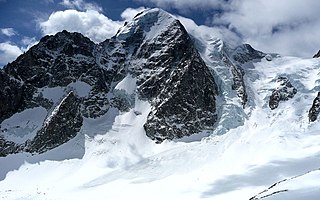
The Finsteraarhorn is a mountain lying on the border between the cantons of Bern and Valais. It is the highest mountain of the Bernese Alps and the most prominent peak of Switzerland. The Finsteraarhorn is the ninth-highest mountain and third-most prominent peak in the Alps. In 2001 the whole massif and surrounding glaciers were designated as part of the Jungfrau-Aletsch World Heritage Site.
Bernese German is the dialect of High Alemannic German spoken in the Swiss plateau (Mittelland) part of the canton of Bern and in some neighbouring regions. A form of Bernese German is spoken by the Swiss Amish affiliation of the Old Order Amish in Adams County, Indiana, United States, as well as and other settlements in the US, primarily in Indiana.

The Aletschhorn is a mountain in the Alps in Switzerland, lying within the Jungfrau-Aletsch region, which has been designated a World Heritage Site by UNESCO. The mountain shares part of its name with the Aletsch Glacier lying at its foot.

The Bernese Oberland is the highest and southernmost part of the canton of Bern, and one of the canton's five administrative regions. It constitutes the Alpine region of the canton and the northern side of the Bernese Alps, including many of its highest peaks, among which the Finsteraarhorn, the highest in both range and canton.

The Schreckhorn is a mountain in the Bernese Alps. It is the highest peak located entirely in the canton of Berne. The Schreckhorn is the northernmost Alpine four-thousander and the northernmost summit rising above 4,000 metres in Europe.
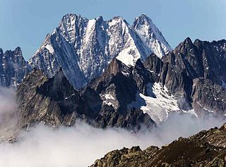
The Lauteraarhorn is a peak of the Bernese Alps, located in the canton of Bern. Together with the higher Schreckhorn, to which it is connected by a high ridge, it lies between the valleys of the Lower Grindelwald Glacier and the Unteraar Glacier, about 10 kilometres southeast of Grindelwald, the closest locality. The Lauteraarhorn belongs to the Aaremassif and is surrounded by large glaciers: the Lauteraargletscher and the Strahlegg-Gletscher and the Obers Ischmeer. Being off the main ridge of the Bernese Alps, all the glaciers surrounding the Lauteraarhorn and the Schreckhorn are part of the Aare basin. The Lauteraarhorn is the second highest summit lying wholly within the canton of Bern. Administratively, it is split between the municipalities of Grindelwald and Guttannen.

The Wildstrubel is a mountain of the Alps, straddling the border between the Swiss cantons of Bern and Valais. It forms a large glaciated massif, about 15 km wide, extending between the Rawil Pass and the Gemmi Pass. Along with the Muverans, the Diablerets and the Wildhorn, the Wildstrubel is one of the four distinct mountain massifs of the Bernese Alps that lie west of the Gemmi Pass. The massif of the Wildstrubel is at the centre between the valleys of Simmental (BE), Engstligental (BE) and the Rhone (VS), the exact location of the tripoint being the summit of the Schneehorn. It comprises several distinct summits, including the Wetzsteinhorn, the Rohrbachstein, the Weisshorn, the Pointe de la Plaine Morte, Mont Bonvin, the Trubelstock and the Schneehorn. The main crest with the almost equally high summits of the Mittelgipfel and the Grossstrubel forms an amphitheatre oriented eastward which ends at the Steghorn and the Daubenhorn. This area encloses the Wildstrubel Glacier. To the southwest, the Wildstrubel overlooks the high plateau of the Plaine Morte Glacier, which also includes an unnamed lake below the Schneehorn.

The Bernese March is the traditional anthem of the Swiss Canton of Bern and is played at official occasions.

The Wildhorn is a mountain of the Alps, straddling the border between the Swiss cantons of Bern and Valais. At 3,248 metres (10,656 ft) above sea level, it is the highest summit of the Bernese Alps west of the Gemmi Pass. It forms a large glaciated massif, about 10 km wide, extending between the Sanetsch Pass and the Rawil Pass. Along with the Muverans, the Diablerets and the Wildstrubel, the Wildhorn is one of the four distinct mountain massifs of the Bernese Alps that lie west of the Gemmi Pass. The massif of the Wildhorn is at the centre between the valleys of the Saane, Simme and the Rhone (Valais). It comprises several distinct summits, including the Arpelistock, Le Sérac, the Geltenhorn, the Sex Noir, the Sex Rouge, the Schnidehorn and the Six des Eaux Froides. The main crest is between the glaciers named Tungelgletscher and Glacier du Wildhorn. South of the main summit is the almost equally high summit of Mont Pucel. The Wildhorn is surrounded by several large mountain lakes: the Lac de Sénin, the Lauenensee, the Iffigsee, the Lac de Tseuzier and the Lac des Audannes. The Tungelgletscher, on the north-east face, was measured as 1.9 km in length in 1973.

The Ebnefluh, also known as the Äbeni Flue and the Ebenefluh, is a mountain of the Bernese Alps, located on the border between the Swiss cantons of Bern and Valais. It lies towards the eastern end of the Lauterbrunnen Wall.
The Nesthorn is a mountain in the Bernese Alps. It is located in the Swiss canton of Valais north of Brig. The mountain lies between the Oberaletsch Glacier on the north and east side and the Gredetschtal on the south side. It is part of the subrange of the Bernese Alps that culminates at the Aletschhorn.

The Dent de Morcles is a 2,969 metres high mountain located at western end of the Bernese Alps, overlooking the Rhone between Martigny and St. Maurice. It is the westernmost summit of the Muverans massif, which in turn is the westernmost of the four distinct mountain massifs of the Bernese Alps that lie west of the Gemmi Pass. Its position at the end of this chain of mountains and the abrupt drop to the wide valley of the Rhone river below make the Dent de Morcles prominently visible from many points in Lausanne and other populated areas on the north and northeastern shores of Lake Geneva.
The Grand Muveran is a mountain of the Bernese Alps, located on the border between the cantons of Vaud and Valais. At 3,051 metres, it is the highest summit of the group lying between the Rhone knee and the Pas de Cheville and the westernmost three-thousander of the Bernese Alps. The closest localities are Les Plans-sur-Bex and Ovronnaz (Valais). It is accompanied by the smaller peak of Petit Muveran.

The Schwarzhorn is a mountain of the Bernese Alps, located between Brienz and Grindelwald in the Bernese Oberland. With a height of 2,928 metres above sea level, it is the highest summit of the group north of the Grosse Scheidegg Pass. The Schwarzhorn is also the highest point in the municipality of Brienz.

The Schweizerischer Niederlaufhund, is a breed of dog of the scenthound type from Switzerland. Niederlaufhund means short-legged hound. The breed has a number of different varieties.
The International Bernese Ladies Cup is an annual bonspiel which was started in 1968 and became an event on the women's World Curling Tour in 2007. It is held every January at the Curlingbahn Allmend in Bern, Switzerland.

