Omatjette

Last updated
Omatjette
Settlement
Namibia location map.svg
Red pog.svg
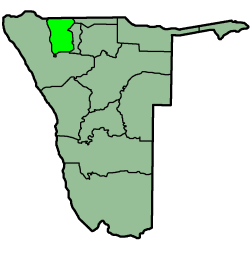
Omatjette
Location in Namibia
Coordinates: 21°3′S15°30′E / 21.050°S 15.500°E / -21.050; 15.500 Coordinates: 21°3′S15°30′E / 21.050°S 15.500°E / -21.050; 15.500
CountryFlag of Namibia.svg  Namibia
Region Erongo Region
Constituency Dâures Constituency
Population
  Total 12,000
Time zone South African Standard Time (UTC+1)

Omatjette (also: Omatjete) is a village in the Erongo Region of Namibia, situated on the road D2344 from Omaruru to Khorixas. It belongs to the Dâures electoral constituency but there are plans to split from it to become a constituency on its own. Omatjette has approximately 12,000 residents, many of them living there only temporarily. [1]

Erongo Region Region in Namibia

Erongo is one of the 14 regions of Namibia. The capital is Swakopmund. The region comprises the Swakopmund magisterial district up to the Ugab River and includes the Walvis Bay, Omaruru and Karibib magisterial districts. This region is named after Mount Erongo, a well-known landmark in Namibia and in this area. All the main centres within this region are connected by paved roads. The Governor of Erongo Region is Cleophas Mutjavikua.

Namibia republic in southern Africa

Namibia, officially the Republic of Namibia, is a country in southern Africa. Its western border is the Atlantic Ocean; it shares land borders with Zambia and Angola to the north, Botswana to the east and South Africa to the south and east. Although it does not border Zimbabwe, less than 200 metres of the Zambezi River separates the two countries. Namibia gained independence from South Africa on 21 March 1990, following the Namibian War of Independence. Its capital and largest city is Windhoek, and it is a member state of the United Nations (UN), the Southern African Development Community (SADC), the African Union (AU), and the Commonwealth of Nations.

Omaruru, Namibia City in Erongo Region, Namibia

Omaruru is a city and constituency in the Erongo Region of Namibia. The town has 14,000 inhabitants and owns 352 square kilometres (136 sq mi) of land. The town is situated near Mount Erongo, on the usually dry Omaruru River. It is located on the main paved road from Swakopmund to Otjiwarongo. The name in the local Otjiherero language means 'bitter milk', as the cattle used to browse on a local bush that turned their milk bitter.

The village name was originally Omatjate (Otjiherero: tasty water), referring to a fountain that today is on the western edge of the settlement. The water-related name of the settlement and surrounding geographical features stems from the scarcity and value of water in this semi-arid terrain; the Omatjette area only receives about 400mm of annual rain. The village is not connected to Namibia's water network. [2]

The Namibia Water Corporation or NamWater is a parastatal in Namibia. It is wholly owned by the Ministry of Agriculture of the Government of Namibia. The company employs over 600 people.

Related Research Articles

ǁKaras Region Region in Namibia

The ǁKaras Region, also spelled !Karas Region, is the southernmost and least densely populated of the 14 regions of Namibia; its capital is Keetmanshoop. The name assigned to the region reflects the prominence of the Karas mountain range in its southern part. The ǁKaras region includes the magisterial districts of Keetmanshoop, Karasburg, Bethanie, and Lüderitz.

Omusati Region Region in Namibia

Omusati region is one of the fourteen regions of Namibia, its capital is Outapi. The region's name Omusati, comes from the Oshiwamo word 'omusati' which means 'Mopane'. Mopani tree is the dominant species in the region; the Makalani palms decrease rapidly westwards from the border with Oshana region. The change in vegetation type reflects ecological conditions forming a natural boundary between the two regions.

Ohangwena Region Region in Namibia

Ohangwena is one of the fourteen regions of Namibia, its capital is Eenhana. The northern and western parts of the region are the most densely populated of this essentially subsistence agricultural region in which small scale mahangu cultivation and the keeping of cattle form the predominant activities. Although the region depends on rain fed agriculture, other crops can be established under intensive cultivation.

Dâures Constituency constituency of Namibia

Dâures is a constituency in the Erongo Region of Namibia. Its former name was Brandberg constituency, after the tallest mountain in Namibia, the Brandberg. Its population is 10,184. Dâures Constituency extends from the national road B2 to the Ugab River and has a radius of approximately 120 km. The largest settlement in the constituency is Uis. It also contains the settlements of Okombahe and Omatjette, as well as the smaller populated places of Omihana, Ovitua, Odama, Okamapuku, Ozondati, and Tubusis.

Brandberg may refer to:

Berseba village in ǁKaras Region, Namibia

Berseba is a village in the ǁKaras Region of southern Namibia and the district capital of the Berseba electoral constituency. It is situated 100 km (62 mi) north-west of Keetmanshoop near the Brukkaros Mountain, a famous tourist destination.

Khorixas Place in Kunene Region, Namibia

Khorixas is a town of 6,000 inhabitants in southern Kunene Region, Namibia. It was the capital of the Damaraland bantustan before Namibia's independence. It is the administrative capital of Khorixas Constituency. Most of the inhabitants are from the Damara ethnic group. The town is located near to an important deposit of petrified wood and the Twyfelfontein valley, known for its rock art.

Uis Village in Erongo Region, Namibia

Uis is a settlement located in Erongo Region, Namibia. It belongs to the Dâures electoral constituency. Located in the former Damaraland, it is known for the local mineral wealth. The settlement has approximately 3,600 inhabitants and, before being downgraded from "village" to "settlement" in 2010, owned 10 square kilometres (3.9 sq mi) of land.

Felicia gunillae is a species of flowering plant in the family Asteraceae. It is endemic to Namibia, where it is known only from Dâures Constituency.

Eheke Place in Oshana Region, Namibia

Eheke is a settlement in northern Namibia situated at the edge of the Oshana Region near Ondangwa Airport. Eheke has c. 1,150 inhabitants and is situated 15 kilometres (9.3 mi) west of Ondangwa near Omagongati. Eheke was the administrative centre for Ondangwa Constituency, and after a split of this constituency in 2013 it is the centre of the Ondangwa Rural constituency.

Endola is a constituency in the Ohangwena Region of Namibia, on the border of Angola. It has 36,659 inhabitants, the district centre is the settlement of Endola. Ferdinand Ingashipola Shifidi became a councillor of the constituency in November 2014 and was re-elected in 2015.

Epembe Constituency constituency of Namibia

Epembe is a constituency in the Ohangwena Region of Namibia, on the border to Angola. It has 14,837 inhabitants, the district centre is the settlement of Epembe.

Aminuis Constituency

Aminuis Constituency is a electoral constituency in the Omaheke Region of Namibia. It has 12,343 inhabitants, its district capital is the settlement of Aminuis. The constituency forms part of the border between Namibia and Botswana.

Donkerbos settlement in Omaheke Region, Namibia

Donkerbos is a settlement in the remote East of Namibia in Omaheke Region, situated 260 kilometres (160 mi) from the regional capital Gobabis.

Sonneblom settlement in Omaheke Region, Namibia

Sonneblom is a settlement in the remote East of Namibia in Omaheke Region, situated 260 kilometres (160 mi) from the regional capital Gobabis.

Kavango East Region in Namibia

Kavango East is one of the fourteen regions of Namibia. Its capital is Rundu. Because of its rather higher rainfall than most other parts of Namibia, this region has agricultural potential for the cultivation of a variety of crops, as well as for organised forestry and agro-forestry, which stimulates furniture making and related industries.

Eiseb Village in Omaheke Region, Namibia

Eiseb, also Eiseb Block, is a settlement in the Omaheke Region of Namibia. It is named after the Eiseb River, an ephemeral river (omuramba) in the Kalahari desert. Eiseb is situated on the District road D1635 c. 350 kilometres (220 mi) northeast of Talismanus and belongs to the Otjombinde electoral constituency.

NS <i>Daures</i>

NS Daures (C12) is a patrol boat of the Namibian Navy and sister ship of NS Brukkaros. Formerly a People's Liberation Army Navy Haiqing-class submarine chaser, it was commissioned on 27 October 2017 into the Namibian Navy. The vessel is used to patrol Namibia's exclusive economic zone.

References

  1. Heita, Desie (20 April 2010). "Omatjette wants split from Daures". New Era .
  2. Tjituka, Martin (19 April 2013). "Can a water project restore a marriage?". The Namibian . Archived from the original on 20 April 2013.