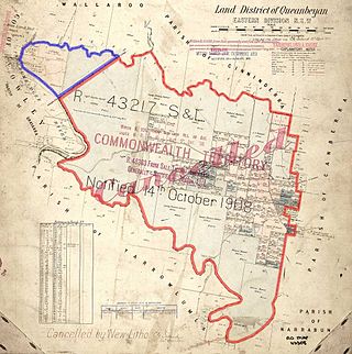
It is at the north-eastern end of the longest straight-line section of the border, with Mount Coree at the south-western end. North and east of One Tree Hill, the border is formed by the watershed of the Molonglo River catchment. One-Tree Trigonometrical Station is nominated in the description of the Australian Capital Territory, in the Second Schedule of the Seat of Government Acceptance Act 1909.[2] In 2022, it was announced that there would negotiations on a change to the straight-line section of the border; the border south-west from One Tree Hill will follow the current straight line, but only to the point where it intersects Ginninderra Creek. The other straight-line from Mount Coree will end at the Murrumbidgee River, with the land enclosed by the right bank of the Murrumbidgee and the left bank of Ginninderra Creek to become part of the ACT.[3][4]
One Tree Hill lies on the traditional lands of Ngunnawal people.[5]
Robert Dixon in 1830[6] and Robert Hoddle, between 1830 and 1836, used One Tree Hill as a high point from where to view the area and as a landmark from which they took bearings, while surveying the area.[7]
It was the location at which Charles Scrivener began his detailed topographical survey of the area for the new capital site of Canberra. Later, it was an important location for the survey of the border of the new Australian Capital Territory.[7]
One Tree Hill is a popular walking destination and lies on the Canberra Centenary Trail. The lookout at the top of the hill provides a panoramic view in all directions.[8]
There is a Telstra telecommunications tower on the hill.[9]
↑ Australian Institute of Aboriginal and Torres Strait Islander Studies (10 January 2021). "Map of Indigenous Australia". aiatsis.gov.au. Retrieved 3 October 2021.
↑ Cranfield, Louis R., "Dixon, Robert (1800–1858)", Australian Dictionary of Biography, Canberra: National Centre of Biography, Australian National University, retrieved 3 October 2021
The Australian Capital Territory (ACT), known as the Federal Capital Territory (FCT) until 1938, is a federal territory of Australia. Canberra, the capital city of Australia, is located in this territory. It is located in southeastern Australian mainland as an enclave completely within the state of New South Wales. Founded after Federation as the seat of government for the new nation, the territory hosts the headquarters of all important institutions of the Australian Government.
The Legislative Assembly for the Australian Capital Territory is the unicameral legislature of the Australian Capital Territory (ACT). It sits in the Legislative Assembly Building on Civic Square, close to the centre of the city of Canberra.
Belconnen is a district in the Australian Capital Territory in Australia. The district is subdivided into 27 divisions (suburbs), sections and blocks.
North Canberra, or the Inner North, is a subdivision of Canberra Central in the Australian Capital Territory in Australia. Comprising 14 suburbs. At the 2021 census, it had 26,699 dwellings housing 61,188 people of the 453,324 people in the Australian Capital Territory. Many of Canberra's oldest dwellings are located on it.
Tuggeranong is a district in the Australian Capital Territory in Australia. The district is subdivided into divisions (suburbs), sections and blocks and is the southernmost district of the Australian Capital Territory. The district comprises nineteen suburbs and occupies 117 square kilometres (45 sq mi) to the east of the Murrumbidgee River.
The Brindabella Range, commonly called The Brindabellas or The Brindies, is a mountain range located in Australia, on a state and territory border of New South Wales and the Australian Capital Territory (ACT). The range rises to the west of Canberra, the capital city of Australia, and includes the Namadgi National Park in the ACT and the Bimberi Nature Reserve and Brindabella National Park in New South Wales. The Brindabellas are visible to the west of Canberra and form an important part of the city's landscape.
Dunlop is a suburb of the Belconnen district of Canberra, located within the Australian Capital Territory, Australia. Dunlop is at the far north-west edge of Canberra, near the border with the state of New South Wales. Approximately 11.6 kilometres (7.2 mi) north-west of the city, Dunlop is next to the suburbs of Fraser, Charnwood and Macgregor. At the edge and within Dunlop lies the Canberra Nature Park called Dunlop Grasslands Nature Reserve, West Belconnen Ponds, Jarramlee Pond and Fassifern Pond which are part of the Ginninderra Catchment.
Evatt is a suburb in the Belconnen district of Canberra, located within the Australian Capital Territory, Australia. Evatt lies between the suburbs of McKellar, Belconnen, Florey, Melba and Spence.
Nicholls is a suburb in the Canberra, Australia district of Gungahlin. It was named after Sir Douglas Nicholls (1906–1988) who was born at Cummeragunja Aboriginal mission, New South Wales. Nicholls was a footballer, pastor, activist, and Governor of South Australia, 1976–1977. In line with the philosophy of naming Canberra's streets, those of Nicholls are named after sportspeople. The suburb incorporates a large shallow body of water, designated Gungahlin Pond, with The Lakes golf course and the greatest number of residential streets on one side and a small cluster of residential streets, the "pondside promenade", named after birds, on the other. There is no direct connecting road between the two.
Hall is a town in the district of Hall, in the Australian Capital Territory in Australia. Is situated on the north side of the Australian Capital Territory. At the 2021 census, the village had a population of 298 people. It is surrounded by open country and has a rural appearance. Hall has retained a village character. The town features historic buildings that existed before the establishment of Canberra.
Uriarra Village is a town in the district of Coree, in the Australian Capital Territory in Australia. It is situated on the western side of the Australian Capital Territory, about 30 minutes from Canberra, established in 1928 at the foothills of the Australian Alps. A nearby area to the north of the border in New South Wales is also called Uriarra.
The Seat of Government Acceptance Act 1909 is an Australian Commonwealth Government act, that in conjunction with the Seat of Government Surrender Act 1909 transferred land from the state of New South Wales to the Commonwealth for the creation of the Federal Capital Territory.
From 2016, the 25-member unicameral Australian Capital Territory Legislative Assembly is elected from five multi-member electorates, with five seats per electorate.
Murray County was one of the original Nineteen Counties in New South Wales and is now one of the 141 Lands administrative divisions of New South Wales. It included the area which is now part of Canberra and as far north as Lake George and Yass. It was originally bounded on the west by the Murrumbidgee River, on the east by the Shoalhaven River and on the north by the Yass River. A large area of the county was transferred to the Commonwealth government in 1909 in the Seat of Government Acceptance Act to make part of the Australian Capital Territory, along with land in Cowley County. Since then, the ACT border is now part of the western boundary. Part of the ACT border is determined by property boundaries in the Parish of Keewong, in the County of Murray; specifically the southern end of portions 177, 218, 211, 36, and 38. This is mentioned in the Seat of Government Acceptance Act of 1909.
Weetangera Parish is a parish of Murray County, New South Wales, Australia, a cadastral unit for use on land titles. It is now very small, after most of the land in the parish was transferred to the Australian Capital Territory in 1911, but it once included the south-west part of what is now the Canberra town centre of Belconnen including the town centre. It currently includes a small section of land in New South Wales between the ACT border, Ginninderra Creek and the Murrumbidgee River.
Ginninderra Creek, a partly perennial stream of the Murrumbidgee catchment within the Murray–Darling basin, is located in the Capital Country region spanning both the Australian Capital Territory and New South Wales, Australia.
Ginninderra is the name of the former agricultural lands surrendered to urban development on the western and north-western fringes of Canberra, the capital of Australia. Ginninderra corresponds with the watershed of Ginninderra Creek, which is now in part occupied by the Canberra districts of Belconnen and Gungahlin.
Mount Coree is a mountain with an elevation of 1,421 metres (4,662 ft) AHD that is located within the Brindabella Range on the border between the Australian Capital Territory and New South Wales, Australia. The summit of the mountain is located in the Australian Capital Territory.
The 2020 Australian Capital Territory general election was held between 28 September and 17 October 2020 to elect all 25 members of the unicameral ACT Legislative Assembly.
This page is based on this Wikipedia article Text is available under the CC BY-SA 4.0 license; additional terms may apply. Images, videos and audio are available under their respective licenses.