
Rotterdam is the second-largest city in the Netherlands after the national capital of Amsterdam. It is in the province of South Holland, part of the North Sea mouth of the Rhine–Meuse–Scheldt delta, via the "New Meuse" inland shipping channel, dug to connect to the Meuse at first and now to the Rhine.

Amsterdam Zuid is a railway station situated in the borough of Amsterdam-Zuid in Amsterdam, Netherlands. For a number of years, it was named Amsterdam Zuid WTC, in reference to the neighbouring World Trade Center Amsterdam. During 2006, in conjunction with the rapid development of the area surrounding the station, the station was enlarged and the reference to the WTC was formally dropped from the name.
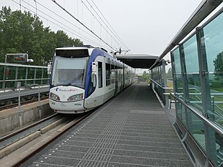
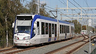
RandstadRail is a tram-train network in the Rotterdam–The Hague metropolitan area in the west of the Netherlands that is jointly operated by HTM Personenvervoer (HTM) and Rotterdamse Elektrische Tram (RET). It connects the cities of Rotterdam, The Hague and Zoetermeer, primarily using former train and existing tram tracks.

Den Haag Centraal is the largest railway station in the city of The Hague in South Holland, Netherlands, and with twelve tracks, the largest terminal station in the Netherlands. The railway station opened in 1973, adjacent to its predecessor: Den Haag Staatsspoor, which was subsequently demolished. It is the western terminus of the Gouda–Den Haag railway.

The Rotterdam Metro is a rapid transit system operated in Rotterdam, Netherlands and surrounding municipalities by RET. The first line, called Noord – Zuidlijn opened in 1968 and ran from Centraal Station to Zuidplein, crossing the river Nieuwe Maas in a tunnel. It was the first metro system to open in the Netherlands. At the time it was also one of the shortest metro lines in the world with a length of only 5.9 km (3.7 mi).

Amsterdam-Noord is a borough of Amsterdam, Netherlands with a population of about 90,000. The IJ, the body of water which separates it from Amsterdam-Centrum and the rest of the city, is situated southwest of Amsterdam-Noord. The borough, which has an area of 49.01 km2, borders the municipalities of Zaanstad, Oostzaan, Landsmeer and Waterland to the north, all part of the province of North Holland like Amsterdam. It borders the Markermeer to the east.

Beurs is a major subway interchange station in the center of Rotterdam. Underneath Churchill Square, the two lines through the city center intersect. Passengers for Rotterdam Central Station change here to line D or E if they started their journey on line A, B, or C.

The history of rail transport in the Netherlands is generally considered to have begun on September 20, 1839, when the first train, drawn by De Arend, successfully made the 16 km (9.9 mi) trip from Amsterdam to Haarlem. However, the first plan for a railroad in the Netherlands was launched only shortly after the first railroad opened in Britain.

Den Haag Laan van NOI railway station is a railway station in the Netherlands, on the border between The Hague and the town of Voorburg. It is served by the Nederlandse Spoorwegen and by the RandstadRail light-rail network. The station is named after the road on which it is located, Laan van Nieuw Oost-Indië, which literally translates as New East Indies Avenue, but probably refers to a former inn called Nieuw Oosteinde.

Alkmaar railway station serves the town of Alkmaar, Netherlands. It is located approximately 40 km (25 mi) northwest of Amsterdam. The station opened on 20 December 1865 and is located on the Den Helder–Amsterdam railway. The train services are operated by Nederlandse Spoorwegen and it is an Intercity station, where all trains stop.

The Hofpleinlijn(Spoorlijn Rotterdam Hofplein - Scheveningen) was one of the two railways between the Dutch cities of The Hague and Rotterdam. In 2006 it was converted to metro-like operation as RandstadRail line E.
Breda railway station is a railway station in Breda in North Brabant, Netherlands. It is situated on the Breda–Rotterdam railway, the Roosendaal–Breda railway and the Breda–Eindhoven railway.

Rotterdam Centraal station is the main railway station of the city Rotterdam in South Holland, Netherlands. The station received an average of 112,000 passengers daily in 2019. The current station building, located at Station Square, was officially opened in March 2014.

Rotterdam Noord is a railway station in the city of Rotterdam in the Netherlands, located on the Utrecht–Rotterdam railway. It sits at the border between the two Rotterdam boroughs Noord and Hillegersberg-Schiebroek.
High-speed rail service in the Netherlands started on 13 December 2009 with the dedicated HSL-Zuid line that connects the Randstad via Brussels to the European high-speed rail network. In later years improved traditional rail sections were added to the high-speed network. Proposals for more dedicated high-speed lines were deemed too costly; plans for the HSL-Oost to Germany were mothballed and instead of the Zuiderzeelijn the less ambitious Hanzelijn was built to enable future high-speed service between the northern provinces and the Randstad.

Tilburg railway station is a railway station located in Tilburg in the province of North Brabant, Netherlands. The station was opened on 5 October 1863 and is located on the Breda–Eindhoven railway and Tilburg–Nijmegen railway. The train services are operated by Nederlandse Spoorwegen (NS).

Noord is a borough of Rotterdam. The municipal portion is formed by the Delfshavense Schie, the Highway 20 (A20), the Rotte and the rails. The borough had 51,796 inhabitants in 2017.
The Hague Tram is a tram network forming part of the public transport system in and around the city of The Hague in South Holland, Netherlands.
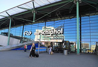
Schiphol Airport station is a major passenger railway station in Haarlemmermeer, Netherlands, beneath the terminal complex of Amsterdam Airport Schiphol, operated by the Nederlandse Spoorwegen. The station's six platforms are accessible via twelve escalators and three elevators located in the main concourse of the airport. The original station was opened in 1978, and the current station in 1995. It connects the airport to Amsterdam and other cities in the Netherlands, as well as to Belgium and France.

De Noord was a tower mill located on the Oostplein in Rotterdam, Netherlands. It was built between 1695 and 1711 as a replacement for a post mill which had stood at the site since around 1562. De Noord was used as a malt mill until the nineteenth century, when it switched to grinding grain for animal feed.
