
Sørfold is a municipality in Nordland county, Norway. It is part of the traditional district of Salten. The administrative centre of the municipality is the village of Straumen. Other villages in the municipality include Leirfjordgården, Mørsvikbotn, Røsvika, Rørstad, Styrkesvik, and Øvre Kvarv. The municipality surrounds the Sørfolda fjord and stretches east to the border with Sweden.
Steigen is a municipality in Nordland county, Norway. It is part of the traditional district of Salten. The administrative centre of the municipality is the village of Leinesfjord. Other villages include Bogen, Leines, Nordfold, Nordskot, and Sørskot. Engeløy Airport, Grådussan is located in the northern part of the municipality. Måløy–Skarholmen Lighthouse is located in the Vestfjorden in the western part of the municipality. The only road access to the municipality is via the Steigen Tunnel.

Hamarøy (Norwegian) or Hábmer (Lule Sami) is a municipality in Nordland county, Norway. It is part of the traditional district of Salten. The administrative centre of the municipality is the village of Oppeid. Other villages include Innhavet, Karlsøy, Presteid, Skutvika, Tømmerneset, Tranøy, and Ulvsvåg.
Tysfjord (Norwegian) or Divtasvuodna (Lule Sami) is a municipality in Nordland county, Norway. It is part of the traditional district of Ofoten. The administrative centre of the municipality is the village of Kjøpsvik. Other villages include Drag, Hundholmen, Korsnes, Musken, Rørvika, Skarberget, and Storå.
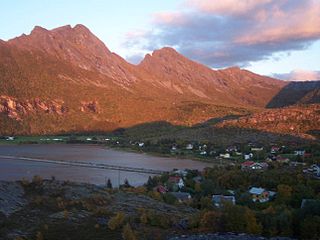
Skutvika or Skutvik is a small village in the municipality of Hamarøy in Nordland county, Norway. The village is situated at the southwestern extreme of the Hamarøya peninsula, about 90 kilometres (56 mi) north of the town of Bodø, 95 kilometres (59 mi) southwest of the town of Narvik, and 40 kilometres (25 mi) south of the town of Svolvær. To the west and south of Skutvik is the Økssundet, a sound connecting the Sagfjorden and Vestfjorden. The landscape in the immediate vicinity of the village is dominated by hills, while further north a row of mountains rises up to 950 metres (3,120 ft) above sea level.

Forsvatnet (Norwegian) or Gårttjejávrre (Lule Sami) is a lake that lies on the border of the municipalities of Sørfold and Hamarøy in Nordland county, Norway. The 13.63-square-kilometre (5.26 sq mi) lake lies about 20 kilometres (12 mi) southeast of the village of Mørsvikbotn.
Kaldvågvatnet or Kallvågvatnet is a lake in the municipality of Hamarøy in Nordland county, Norway. It is located about 7 kilometres (4.3 mi) east of the municipal centre, Oppeid. The lake Skilvatnet lies immediately east of this lake.
Kilvatnet (Norwegian) or Ráhpukjávrre (Lule Sami) is a lake in the municipalities of Hamarøy and Tysfjord in Nordland county, Norway. The lake is located about 4 kilometres (2.5 mi) east of the village of Ulvsvåg.
Livsejávrre is a lake in the municipality of Hamarøy in Nordland county, Norway. It is located about 20 kilometres (12 mi) southeast of the village of Mørsvikbotn and about 6 kilometres (3.7 mi) west of the border with Sweden. The ending -jávrre is the Lule Sami language word for lake.
Makkvatnet (Norwegian) or Suoksavuomjávrre (Lule Sami) is a lake that lies on the border of the municipalities of Steigen and Hamarøy in Nordland county, Norway. The 3.02-square-kilometre (1.17 sq mi) lake lies about 5 kilometres (3.1 mi) west of the European route E06 highway in Hamarøy.
Reinoksvatnet (Norwegian) or Hierggejávrre (Lule Sami) is a lake in the municipality of Hamarøy in Nordland county, Norway. It is located about 20 kilometres (12 mi) east of the village of Mørsvikbotn and less than 2 kilometres (1.2 mi) west of the border with Sweden.
Skilvatnet is a lake in the municipalities of Hamarøy and Tysfjord in Nordland county, Norway. The lake lies about 10 kilometres (6.2 mi) east of the municipal centre of Hamarøy, Oppeid. The lake Kaldvågvatnet lies just west of this lake.

Skrova is a small island group and village area in Vågan Municipality in Nordland county, Norway. The 2.5-square-kilometre (0.97 sq mi) Skrova island group in the Lofoten archipelago, about 9 kilometres (5.6 mi) southeast of the town of Svolvær. It is located in the Vestfjorden, south of the islands of Austvågøya, Litlmolla, and Stormolla. The largest island in the group is Storskrova and the island of Heimskrova is where most of the population is located. The six main inhabited islands in the group are all interconnected by a small bridge and several man-made causeways.

Leiranger is a former municipality in Nordland county, Norway. The 185-square-kilometre (71 sq mi) municipality existed from 1900 until its dissolution in 1964. The municipality was encompassed the around the Leinesfjorden and the islands surrounding the mouth of the fjord in what is now Steigen Municipality. The administrative centre of Leiranger was the village of Leines. The village of Leinesfjorden lies at the end of the fjord.
Finnøya is an island in Hamarøy Municipality in Nordland county, Norway. The island is situated northwest of the village of Innhavet with which it is connected by bridge. The mountainous island has an area of 68 square kilometres (26 sq mi) and the highest point is the 436-metre (1,430 ft) tall mountain Straumfjellet. In 2016, the island of Finnøya had a population of 75.
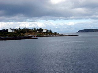
Tranøy or Tranøya is a village and ancient trade centre in the municipality of Hamarøy in Nordland county, Norway. It is located on the end of a peninsula about 14 kilometres (8.7 mi) north of the municipal centre, Oppeid. The Tranøy Lighthouse is located west of the village on a small islet connected to the mainland by a pedestrian bridge.
Tømmerneset is a village in the municipality of Hamarøy in Nordland county, Norway. It's located on the eastern shore of the lake Rotvatnet, about 50 kilometres (31 mi) south of the municipal centre, Oppeid. Tømmerneset is the site of Tømmernes Church. The village area is located where County Road 835 branches off from the European Road E6 highway.

Presteid is a village in the municipality of Hamarøy in Nordland county, Norway. It is located immediately east of the village of Oppeid, along the Presteidfjorden. Presteid is part of the Oppeid urban area which has a population (2018) of 551.

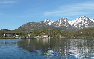
Karlsøy is a village in the municipality of Hamarøy in Nordland county, Norway. It is located on the southern coast of the island of Finnøya, along the Sagfjorden, about 8 kilometres (5.0 mi) northwest of the village of Innhavet. Sagfjord Church is located in Karlsøy, serving the residents of this part of Hamarøy.
Nordfold is a former municipality in Nordland county, Norway. The 561-square-kilometre (217 sq mi) municipality existed from 1906 until its dissolution in 1964. The municipality surrounded the Nordfolda branch off of the Folda fjord in what is now Steigen Municipality, plus a small portion of the present-day Sørfold Municipality. The administrative centre of the municipality was the village of Nordfold, where the Nordfold Church is located.


