This article needs additional citations for verification .(August 2015) |
Oranda is a village located in the Gurudijhatia Block of the Athagad Tehsil of the Cuttack District of the Indian state of Odisha.
This article needs additional citations for verification .(August 2015) |
Oranda is a village located in the Gurudijhatia Block of the Athagad Tehsil of the Cuttack District of the Indian state of Odisha.
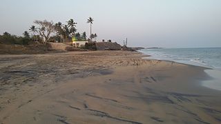
Oranda is located 16 kilometres (9.9 mi) north of the Cuttack district headquarters, 20 kilometres (12 mi) from Athagad, and 38 kilometres (24 mi) from the Bhubaneswar state capital.
Athagad Tehsil lies to Oranda's west, Baranga Tehsil to its south, Tangi Choudwar Tehsil to its east and Gondia Tehsil to its north. Oranda is on the border of the Cuttack District and Dhenkanal District. Dhenkanal is to the west of Oranda.
Gurudijhatia is the nearest town. [1] Cuttack and Dhenkanal are near Oranda.
As per the constitution of India and Panchyati Raaj Act, Oranda village is administered by a "Sarpanch" (Head of Village), its elected representative. [2]
As of 2011 [update] Census, Oranda has a population of 1226, of which 621 are males and 605 are females. The population of children ages 0–6 is 109, 8.89% of the total. The sex ratio is 974, lower than the state average of 979. The child sex ratio is 982, higher than the Orissa average of 941.
Oranda has a higher literacy rate than Orissa. In 2011, its literacy rate was 84.42% compared to 72.87%. In Oranda, male literacy stands at 90.11% while female literacy is 78.58%.
The village of Oranda is administrated by an elected Sarpanch, who serves as head and representative of the village. [3]
The economy is primarily agriculture and associated industries.
Sambeswar Temple, an ancient temple of Shiva, is the main temple. People from nearby villages come to Sambeswar Temple for worship, inspiration and community activities.
The playground in Oranda is near the village temple. It is used for cricket, football and volleyball. Oranda'a cricket team participates in tournaments.
Sambeswar Youth Club is the backbone for entertainment. They organize cultural activities, such as dramatic performances in the premises of Sambeswar Youth Club.
Orandans depend on three ponds (Kahjuri, Gada,...) for their daily activities.
Dol Purnima and Raja are the main two festivals celebrated by the villagers.
Sambeswar Nodal Upper Primary School is there. There are no high schools or colleges in Oranda. Graduates go to nearby villages, such as Bali and Gurudijhatia, for higher education.

Cuttack district is one of the 30 districts of Odisha state in India. It is located in the coastal part of the state and its administrative headquarters are located in the city of Cuttack. As of 2011 Census, after Ganjam, it is the second most populous district of Odisha, with a population of 2,624,470. The name is an anglicized form of Kataka or Katak meaning Fort – referring to the Barabati Fort. The district is bisected by the river Mahanadi and its numerous distributaries and occupies a large portion of the river's delta. It is bounded by the Angul, Dhenkanal, Nayagarh and Khurda districts to the west while its southern and eastern boundaries touch Puri, Jagatsinghpur, Kendrapara and Jajpur districts.
Kendrapara District is an administrative district of Odisha state in eastern India. The town of Kendrapara is the district headquarters. Kendrapara District is situated in the eastern portion of the state, and is bounded on the north by Bhadrak district, on the east by the Bay of Bengal, on the south by Jagatsinghpur District, on the west by Cuttack District on the northwest by Jajpur District.

Angul is one of the thirty districts of Odisha in eastern India. The city of Angul is the district headquarters of Angul district.

Dadhapatna is a census town in Barang, Cuttack district in the state of Odisha, India.

Deoli is a city and a municipality in Tonk district, 85 km from Kota in the state of Rajasthan, India.
Lokur is a village in Athni tehsil, Belgaum district, in the state of Karnataka, India. According to Census 2011 information the location code or village code of Lokur village is 597287. It is 32 kilometres (20 mi) from the sub-district headquarters at Athni and 122 kilometres (76 mi) from the district headquarters at Belgaum. As per 2009 stats, Mangasuli is the gram panchayat of Lokur village.

Gopalpur Khadana is a village in Baraut tehsil, Baghpat district, Uttar Pradesh, India. The village is administrated by a Sarpanch who is an elected representative.

Baragounia is a small village located in Bantala Tehsil of Angul district, Odisha, India, with a population of 2,310.
Mujagada is a large village located near Bhanjanagar of Ganjam district in Orissa. It is located 89 kilometres (55 mi) north of district headquarters, Chhatrapur, and 159 kilometres (99 mi) from the state capital Bhubaneswar. Asika, Hinjilicut, Phulabani, and Berhampur are nearby. Oriya is the local language here. The main occupation of this village is agriculture.
Sisua is a medium-sized village in the Salepur taluk/mandal/tehsil/block of Cuttack district in the state of Odisha, India, close to the new Sisua Village Jagannath Temple. The village lies South of Cuttack to Kendraparda road left of Sisua village road if traveling South. As of 2009 Kantapara is the gram panchayat of Sisua village
Baunsalundi is a small village in Gram Panchayat Baunsalundi located near Bhanjanagar of Ganjam district in Odisha. It is located 91 km towards North from District Headquarters Chhatrapur. 162 km from State capital Bhubaneswar.. Odia is the Language here.

Saptasajya is a village in Dhenkanal district, Odisha, India. Important establishments include ICAR Saptasajya Mango germplasm bank, High School, Teakwood garden and Bee Farm.
Dihapadhal is a Village located near Bhanjanagar of Ganjam district in Orissa. It is located 104 km towards North from District Headquarters Chhatrapur. 170 km from State capital Bhubaneswar. Bhanjanagar, Lalsingi, Jilundi, Baunsalundi, Inginathi, Sanakodanda are the nearby Villages to Dihapadhal. Odia is the Local Language here.
Sahara is a village in Bichpuri Block in Agra District of Uttar Pradesh State, India. It belongs to Agra Division. It is located 13 km towards west from District headquarters Agra. 3 km from Bichpuri. 356 km from State capital Lucknow

Jamalpur is a village in Phagwara Tehsil in Kapurthala district of Punjab State, India. It is located 46 kilometres (29 mi) from Kapurthala, 6 kilometres (3.7 mi) from Phagwara. The village is administrated by a Sarpanch, who is an elected representative.
Bagwanpur is a village in Bhulath Tehsil in Kapurthala district of Punjab State, India. It is located 4 kilometres (2.5 mi) from Bhulath, 28 kilometres (17 mi) away from district headquarter Kapurthala. The village is administrated by a sarpanch who is an elected representative of the village.

Nathumajra is a village located in Malerkotla Tehsil of Sangrur district in Punjab, India. It is situated 15 kilometres (9.3 mi) away from sub-district headquarter Malerkotla and 50 kilometres (31 mi) away from district headquarter Sangrur. As per 2016 stats, Nathu Majra village is also a gram panchayat.
Bhadon is a village and Gram Panchayat located in Martinganj tehsil of the Azamgarh District in the Indian state of Uttar Pradesh, near the border with Jaunpur District. It is 37.7 kilometres (23.4 mi) north-east of the district headquarters in Azamgarh and 229.9 kilometres (142.9 mi) from the state capital of Lucknow.
Kulei is a traditional Indian village belongs to Angul district of Odisha. Kulei is the 6th most populous village in Samal Barrage sub district of Angul district. The area of the village is 3 km2, making it the 17th largest village in the subdistrict. The population density of Kulei is 516 people per km2. 0.54 km2, (19%) of which is covered with forest.
Khireitangiri is a village located in Patna Tehsil in the Kendujhar District in the Indian state of Odisha.