
U.S. Route 395, also known as U.S. Highway 395, is a north–south United States Numbered Highway that traverses the western states of California, Nevada, Oregon, and Washington. It travels for over 1,300 miles (2,100 km) from a junction in the Mojave Desert at Interstate 15 (I-15) in Hesperia to the Canada–U.S. border near Laurier, Washington. Major cities along its route include Carson City and Reno in Nevada; Kennewick and Pasco in Washington's Tri-Cities region; and Spokane, Washington. US 395 is an auxiliary route of US 95 but never intersects its parent route, which runs further east.

U.S. Route 30 or U.S. Highway 30 (US 30) is an east–west main route in the system of the United States Numbered Highways, with the highway traveling across the northern tier of the country. With a length of 3,073 miles (4,946 km), it is the third longest U.S. highway, after US 20 and US 6. The western end of the highway is at US 101 in Astoria, Oregon; the eastern end is at Virginia Avenue, Absecon Boulevard, and Adriatic Avenue in Atlantic City, New Jersey. The "0" as the last digit in the number indicates that it is a coast-to-coast route and a major east-west route. Despite long stretches of parallel and concurrent Interstate Highways, it has not been decommissioned unlike other long haul routes such as US 66. It is also the only U.S. Highway that has always been coast-to-coast since the beginning of U.S. Route system.

U.S. Route 26 is an east–west United States highway that runs from Seaside, Oregon to Ogallala, Nebraska. When the U.S. highway system was first defined, it was limited to Nebraska and Wyoming; by the 1950s, it continued into Idaho and Oregon. The highway's eastern terminus is in Ogallala, Nebraska at an intersection with Interstate 80. Its western terminus is south of Seaside, Oregon at an intersection with U.S. Route 101. Prior to 2004, the route's last 20 miles (32 km) were co-signed with U.S. Route 101 from the highways' junction south of Seaside north to Astoria where its intersection with U.S. Route 30 was also U.S. 30's western terminus. Long segments of the highway follow the historic Oregon Trail. At its peak, immediately before the establishment of the Interstate Highway System, US 26 was 1,557 miles (2506 km) in length, and terminated in Astoria, Oregon.

U.S. Route 40 or U.S. Highway 40 (US 40), also known as the Main Street of America, is a major east–west United States Highway traveling across the United States from the Mountain States to the Mid-Atlantic States. As with most routes whose numbers end in a zero, US 40 once traversed the entire United States. It is one of the first U.S. Highways created in 1926 and its original termini were in San Francisco, California, and Atlantic City, New Jersey. US 40 currently ends at a junction with I-80 in Silver Summit, Utah, just outside Salt Lake City. West of this point US 40 was functionally replaced with I-80, and as these segments of I-80 were constructed the western portion of US 40 was truncated several times.

U.S. Route 281 (US 281) is a north–south United States Numbered Highway. At 1,875 miles (3,018 km) it is the longest continuous three-digit U.S. Route.

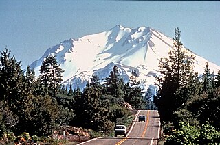
U.S. Route 97 (US 97) is a major north–south route of the United States Numbered Highway System in the Pacific Northwest region. It runs for approximately 670 miles (1,078 km) through the states of California, Oregon, and Washington, primarily serving interior areas on the east side of the Cascade Mountains. The highway terminates to the south at a junction with Interstate 5 (I-5) in Weed, California, and to the north at the Canadian border near Osoyoos, British Columbia, where it becomes British Columbia Highway 97. Major cities on the US 97 corridor include Klamath Falls, Bend, and Redmond in Oregon; and Yakima, Ellensburg, and Wenatchee in Washington. A portion of the highway in California and Oregon is part of the Volcanic Legacy Scenic Byway.

U.S. Route 65 is a north–south United States highway in the southern and midwestern United States. The southern terminus of the route is at U.S. Route 425 in Clayton, Louisiana. The northern terminus is at Interstate 35 just south of Interstate 90 in Albert Lea, Minnesota. Parts of its modern route in Iowa and historic route in Minnesota follow the old Jefferson Highway.
U.S. Route 97 in the U.S. state of Oregon is a major north–south United States highway which runs from the California border, south of Klamath Falls, to the Washington border on the Columbia River, between Biggs Junction, Oregon and Maryhill, Washington. Other than the northernmost stretch, US 97 is known as The Dalles-California Highway. In May 2009, Oregon Senate passed a bill to rename US 97 as "World War II Veterans Historic Highway".

Oregon Route 140 is a state highway in southern Oregon, United States. It is the longest state highway in Oregon, running 237 miles (381 km) from the community of White City, Oregon, through Klamath Falls and on to Lakeview. It then continues east, eventually descending into the state of Nevada.
The Volcanic Legacy Scenic Byway is a scenic highway and All-American Road in the U.S. states of California and Oregon. It is roughly 500 mi (804.7 km) long and travels north–south along the Cascade Range past numerous volcanoes. It is composed of two separate National Scenic Byways, the Volcanic Legacy Scenic Byway - Oregon and Volcanic Legacy Scenic Byway - California. The latter also wholly includes the Lassen Scenic Byway.

State Route 161 is a state highway in the U.S. state of California that runs along the California–Oregon state line in Siskiyou County. It begins at U.S. Route 97 north of Dorris and goes east to the intersection of SR 139 and Oregon Route 39 north of Tulelake. SR 161 is part of the Volcanic Legacy Scenic Byway.

State Route 139 is a state highway in the U.S. state of California. Running from SR 36 in Susanville north to Oregon Route 39 at the Oregon state line, it forms part of the shortest route between Reno, Nevada, and Klamath Falls, Oregon. SR 139 cuts through much of Modoc National Forest and passes near Antelope Mountain and Tule Lake. North of SR 299 near Canby, SR 139 was built by the federal government and turned over to the state in about 1940; the remainder was built by a joint highway district of Lassen and Modoc Counties, completed in 1956, and given to the state in 1959.

Oregon Route 62 is an Oregon state highway that runs between the city of Medford, and U.S. Route 97 between Chiloquin and Klamath Falls. The highway approaches Crater Lake National Park from the south, and is known as the Crater Lake Highway. While the highway is signed east-to-west, it is in reality shaped somewhat like a horseshoe; heading north-northeast from Medford, turning east as it approaches the park, and then turning south-southeast as it approaches Klamath Falls. Oregon Route 140 intersects with OR 62 in White City and Oregon Route 66. These are more direct routes between Medford and Klamath Falls. Route 62 comprises a portion of the Volcanic Legacy Scenic Byway.

Oregon Route 66 is an Oregon state highway that runs between the cities of Ashland and Klamath Falls. The highway is known as the Green Springs Highway No. 21, and is signed east-to-west.

Oregon Route 138 is an Oregon state highway that runs between the city of Elkton and a junction with U.S. Route 97 at Diamond Lake Junction. The highway has several distinct stretches, and is the main east–west highway through Roseburg, and provides access to Crater Lake National Park from the north. The highway is signed east–west.

Oregon Route 422 (OR 422) is an Oregon state highway running from Modoc Point Road near Klamath Agency to US 97 near Chiloquin. OR 422 is known as the Chiloquin Highway No. 422. It is 5 miles (8.0 km) long and runs east–west, entirely within Klamath County.
U.S. Route 97 (US 97) is a United States Numbered Highway, stretching from Weed, California to the Canadian border in Oroville, Washington. The California portion of US 97 runs north from I-5 in Weed to the Oregon state line. This is the majority of a shortcut between I-5 and Klamath Falls, Oregon, added to both states' state highway systems in 1931. It was designated as US 97 in 1935, replacing an east–west section in southern Oregon.

State Route 15 is a west–east route from Memphis to Monteagle. For much of its route it has an unsigned concurrency with U.S. Route 64. SR 15 does travel through the southern part of all 3 Grand Divisions of the state: West Tennessee, Middle Tennessee, and East Tennessee.

State Route 76 (SR 76) is a state highway in Tennessee, traversing the state in a northeast-southwest axis from east of Memphis to north of Nashville. SR 76 is unique in that it actually changes its cardinal directions in Clarksville at the junction with US 41A and US 41A Bypass.
U.S. Route 26 (US 26) runs east–west across south central Idaho for 402.5 miles (647.8 km). US 26 enters the state from Oregon across the Snake River east of Nyssa, Oregon concurrent with US 20 and exits into Wyoming northwest of Alpine. US 26 runs through the large population centers of Boise and Idaho Falls, as well as the smaller communities of Parma, Notus, Garden City, Shoshone, Richfield, Carey, Arco, Blackfoot, Swan Valley, and Irwin.

